Heavenly Days

Thursday, June 26, 2014 Road Junkies 0 Comments

THE BIG CHILL, Epilogue  

Less than an hour after we returned home, we began to wonder whether we had dreamed up Newfoundland and Labrador or if such a place really existed.  Unpacking our bags, we laughed as we pulled out long johns and winter caps.  In the sweltering South, it hardly seemed possible that we wearing such items just a week ago.  Now all that's left is looking back on the memories of two weeks at the eastern edge of the continent.

More than a thousand years ago, the Vikings made landfall on the remote northern coast of what would become Newfoundland—the first Europeans to journey to the New World.  What they found was not unlike what we saw in 2014—rugged coastlines guarded by barren cliffs, rocky landscapes with only a thin layer of soil, and vast expanses of emptiness dotted with huge glacial boulders deposited randomly over the land.  Over the intervening millennium, only the hardiest souls have chosen to make Newfoundland and Labrador their home—those who scoff at the challenges of six months of winter in a land where snow drifts have been known to completely conceal two-story houses, who are willing to drive 30 miles from home to find a tiny plot of soil worthy of gardening, and who crave the combination of solitude and beauty that only this remote land can offer.  And those who choose it don't just tolerate Newfoundland.  They love it fiercely.  We met numerous locals who told us they had tried living elsewhere but couldn't wait to come home to Newfoundland.  (Pictured above:  East Coast Trail at Signal Hill, St. John's)

Light station near Signal Hill
For the rest of us, we'll just visit and enjoy the province on our own terms, rushing home when nature pushes back to separate the men from the boys.  Before we finish up with our visit to this enchanting place, we should state that the correct pronunciation is not 'new-FOUND-land' nor is it 'NEW-fun-len,' as we were prone to say before our visit.  The authentic Newfie pronunciation is 'new-fin-LAND' with emphasis on the land, not its 'new'-ness or its 'found' status.

In our all too brief two weeks traveling around Newfoundland and a tiny, tiny sliver of Labrador, we observed a number of things which we came to think of as distinctively Newfoundlandish.  Though they may exist elsewhere, they occurred there in numbers too large to be coincidence.  Some were self-evident, while others required some assistance from a Newfie to understand their purpose and meaning.

Trash Boxes
Trash Boxes.  Beyond urban areas like St. John's and Corner Brook, virtually every house in Newfoundland has a wooden receptacle near the roadside for the purpose of storing garbage.  They come in an endless variety of designs, some to match the house, some just whimsical.  Some sport the house number, and some even support the mailbox.  Whatever the design, they keep seabirds, bears or whatever other wildlife your neighborhood harbors out of your garbage.

Roadside Woodpiles
Roadside Woodpiles.  Another familiar sight along Newfoundland and Labrador roads, especially in the Northern Peninsula, was an endless string of roadside woodpiles.  Individuals pay a government permit to cut wood on public land.  Then the wood is hauled to a roadside area for storage, where longer logs are arranged in a pyramid, teepee style, to allow them to dry out. Once seasoned, the wood is chopped to stove length and stacked in neat, standard size rows.  Often the telephone number of the pile's owner will be painted on a board and attached to the pile for the convenience of purchasers.  Winter lasts six months in Newfoundland, and fuel prices are very high, so most families go through lots of firewood each year.  

Like the roadside gardens, these woodpiles are not targets for theft.  According to locals, you don't steal from your neighbor in Newfoundland.  The harsh conditions and often brutal winters require a culture of interdependence for survival. 

Firewood Sleds
Firewood Sleds.  For convenience, trees are cut in winter for the following year's firewood.  Since every family owns a snowmobile, hauling the wood from the cutting location to storage is much easier with a snowmobile-pulled sled.  And these are stored along the roadside also.

Roadside Gardens
Roadside Gardens.  As we already mentioned in another blog post, roadsides in Newfoundland, especially those on the northern peninsula, are lined with individually operated gardens.  With topsoil at such a premium, no right-minded Newfoundlander would build a house in a place with loamy soil, so they live on rock on the coast and garden along the highway inland where road construction turned up sufficient arable soil.

Mother-in-Law Doors
Mother-in-Law Doors.  The first time we saw a door with no steps we thought it odd or just incomplete.  After seeing them in larger numbers, even on two story houses, there was a pattern.  According to local lore, most Newfoundland houses were built by the people who live in them.  For practical purposes, they put the entrance at the back through a mud room going into the kitchen.  Then after Newfoundland joined Canada in 1949, the federal government mandated that all houses have a front door and a back door for fire safety.  So Newfoundlanders complied; they installed the front doors.  The mother-in-law moniker should be obvious.

Fishing Stages
Fishing Stages.  Fishing stages are small, usually rudimentary, elevated sheds at water's edge in coastal village harbors.  Vital to the traditional cod industry, stages were used to offload and process fish for salting and drying.  Also known as fishing rooms, these ubiquitous structures inspired the design of Newfoundland's provincial museums in St. John's, which are called The Rooms and which dominate the city skyline.  

Brilliant Color
Brilliant Color.  Whether it's atmospheric conditions or just the halo effect of a colorful palette, we couldn't say, but the colors in Newfoundland appeared much deeper, more saturated to us than in other places.  Whether there is a genuine difference or it was just an optical illusion, our cameras reflected the brilliance also.

Back in 2010, we spent a month-long road trip in the maritime provinces of Canada and wanted to include Newfoundland on our agenda.  Alas, we were traveling in April and May, and ferry service to Newfoundland from Nova Scotia didn't begin until late June.  Four years later, we can say Newfoundland was worth the wait.  From the breathtaking scenery to the hospitable people, the province is a top-notch destination.  In just two weeks, we began to understand the old Newfoundland saying about the afterlife:

You can always tell the Newfoundlanders in heaven.  They're the ones who want to go home.

26 JUNE 2014

Do We Really Have to Leave?

Wednesday, June 25, 2014 Road Junkies 0 Comments

THE BIG CHILL, Chapter 10:  
IN WHICH WE LEARN ABOUT AN ODD IMPORT

Days 14-16:  Labrador to Home

With an 8:00 Monday morning booking, we had to be at the ferry office in Blanc Sablon by 7 to purchase our tickets and get in line.  Guiding drivers where to go and folding in side mirrors on each car, the meticulous ferry agents packed vehicles in the hold with only inches to spare.  These guys would be a great help if you were putting a jigsaw puzzle together.

After parking below deck, we followed the crowd upstairs to one of the passenger lounges. Had our journey been an overnight cruise, rather than just 1.5 hours, berths are available with beds.  Instead we hung out in the cafeteria area, even indulging in a bit of breakfast to supplement the meager rations we stirred up before leaving the hotel.

Reaching Saint Barbe on schedule, the ferry was efficiently unloaded, and we drove south on the familiar Highway 430 down the west coast of Newfoundland.  We had run out of time to stop at the Port au Choix National Historic Site on our way north last week, and this return trip south would offer another opportunity.  When we arrived at the site, however, we learned that Monday was a government holiday—Discovery Day—commemorating John Cabot's 1497 arrival in Newfoundland.  So we didn't visit the prehistoric archaeological sites of Port au Choix on Monday either.  But the local Foodland was open so we were able to secure some lunch supplies.  Even though NL-430 is a main highway in Newfoundland terms, it is more like a county road in the U.S., so food options along the way would be limited.

As Newfoundland's warm weather season drew closer, our chances for seeing whales increased, so Ken focused his attention offshore as I drove.  On numerous occasions we stopped because he "definitely" saw a whale, but each time the binoculars proved him wrong.  He is an excellent wildlife spotter, so we were both confident in his assessments but finally decided we were so eager to see whales we were conjuring them up though they weren't there yet.

So we continued moseying down the coastal road and checked back in at the Holiday Inn Express where we stayed last week in Deer Lake.  With plenty of afternoon left, we decided to drive back east on the TransCanada Highway and visit the town of Howley on the opposite shore of Sandy Lake, not because we knew anything about it but because we had some time and saw it on the map.  Little did we know, we were stepping into a significant piece of Newfoundland history.

In this humble little town (pop. 241), moose were introduced to Newfoundland island in 1904.  With the island's caribou herd dwindling, the government was seeking an alternate source for big game hunting.  Arrangements were made with the neighboring province of New Brunswick, where seven moose were lassoed in deep snow and then transported by sled, rail, ferry and rail again to a wooded area near Howley.  Only four moose survived this lengthy travel ordeal, and they were released—two cows and two bulls.  From those four, the population grew over the next hundred years to a herd of more than 120,000 moose.  Now Newfoundland has the most concentrated moose population in North America.

Howley has memorialized its claim to fame in a city park complete with a large interpretive sign and a 4-ft. statue of a moose, all very nice, except there was something a bit off about the moose.  The second look of our double take revealed the problem.  This moose was equipped with... deer antlers?  Well, that was certainly a mystery to be solved, especially after we found a photo of the beast with his rightful moose antlers on the interpretive sign.

Say what?
There was only one thing to do.  On the way into town, we had passed the Trapper's Lounge, Howley's lone pub and one of only four businesses in town.  We figured it was as good a place as any to begin our investigation into the mutilated moose mystery.  Most of the customers in the pub this late afternoon were outsiders staying at the Howley Tourist Lodge next door; they wouldn't know any more than we did.  Finally, we hooked up with Bob, a native Newfoundlander who has lived in Howley for 15 years.  He didn't know how the moose obtained deer antlers either but his curiosity was aroused.  A regular at the pub, Bob barged into the kitchen to ask the bustling server/bartender/cook/busser Lorna about the anomaly.

Lorna knew the story.  It seems that vandals stole the original bronze antlers off the statue.  With no funds in the town budget for repair, some clever local conceived the money-saving idea of replacing the missing horns with a real rack from a deer.  Bob was just as excited as we were to solve this mystery.  We clinked our bottles of Black Horse with his Bud Light.  No doubt Bob will tell the story every chance he gets.  He seemed like a storyteller kind of guy.

Our Tuesday flight from Deer Lake to Toronto was scheduled for 8:30 p.m., giving us a full day to check out Corner Brook, just 33 miles west on the TransCanada Highway.  With a population pushing 20,000, Corner Brook is the province's largest population center outside the St. John's area.  Target even has a store there.  But we weren't there to shop.

Bottle Cove
Corner Brook sits at the mouth of the Humber River, and we had our sights set on driving out Captain Cook's Trail, also known as Highway 450, a twisting 34 miles of road tracing the southern shore of the Humber Arm of the Bay of Islands.  At the end of this scenic route, we chanced upon the wee village of Bottle Cove (pop. 10).  Like so many coastal villages in the province, Bottle Cove began life as a seasonal French fishing station in the early 1500s.  Typically, those long-ago fishermen set up a temporary base for the fishing season and returned to their home country at season's end.

Humber Arm at Bottle Cove
This area of Newfoundland was explored and mapped by Captain James Cook in the 1760s.  His maps and charts of the Bay of Islands remain accurate enough to be used today.  A trail from the secluded Bottle Cove climbs through a conifer forest to a flat grassy headland which looks across to craggy cliffs.  Below, waves crash over the rocky shore at the edge of the bay.  Cook called this spot 'trail's end,' and locals have erected a monument atop the headland in his honor.  We left a little tribute up there also in the form of our fourth letterbox planted in Newfoundland and Labrador.

In a move to ease us back into the hotter temperatures back in Georgia, the weather fairy sent Corner Brook's temperatures soaring near 80 degrees, diminishing our melancholy as we returned to the local airport to turn in our rental car and catch a flight to Toronto.  Like all small airports, Deer Lake procedures and laid-back staff eased the officiousness of the security screening.

Two uneventful flights later and we were back in Georgia, where the ever faithful Faisal picked us up at the airport without a hitch.  To facilitate our transition back to the reality of summer in the South, the temperature stayed below 90 degrees that day.

Our journey to Newfoundland and Labrador was all we hoped it would be and more.  It was one of the most scenic places we have visited, the people were warm and welcoming, and the weather was just what we were seeking.  Did we really have to leave?

MONDAY, JUNE 23 - WEDNESDAY, JUNE 25, 2014


Our buddy Bob from the Trapper's Lounge
View of Gulf or St. Lawrence from Bottle Cove Trail
Gulf of St. Lawrence from trail's end
Little Port harbor near Bottle Cove

Land Sakes!

Sunday, June 22, 2014 Road Junkies 0 Comments

THE BIG CHILL, Chapter 9:  
IN WHICH WE GO TO THE OTHER SIDE

Days 12 & 13:  Labrador

Dense fog cloaked Highway 430 as we left St. Anthony and Newfoundland's northern coast in the rain Saturday morning, straining to spot any moose that might enter the roadway for a closer look at us.  Perhaps they slept in on Saturday morning because we saw only one, well off the highway, on a stretch of 430 renowned as 'moose alley.'  By the time we reached Flower's Cove, an hour and a half south, the rain had abated, so we paused to check out the Thrombolites Walking Trail (pictured above).

Thrombolites are remnants of bacteria and algae that lived in this spot some 650 million years ago.  In shallow water, huge colonies of microorganisms created layers of biofilm that trapped, bound and cemented grains of limestone together to form rocklike formations, which scientists have named thrombolites.  The only places where thrombolites have been documented are the small coastal village of Flower's Cove (pop. 270) and western Australia.
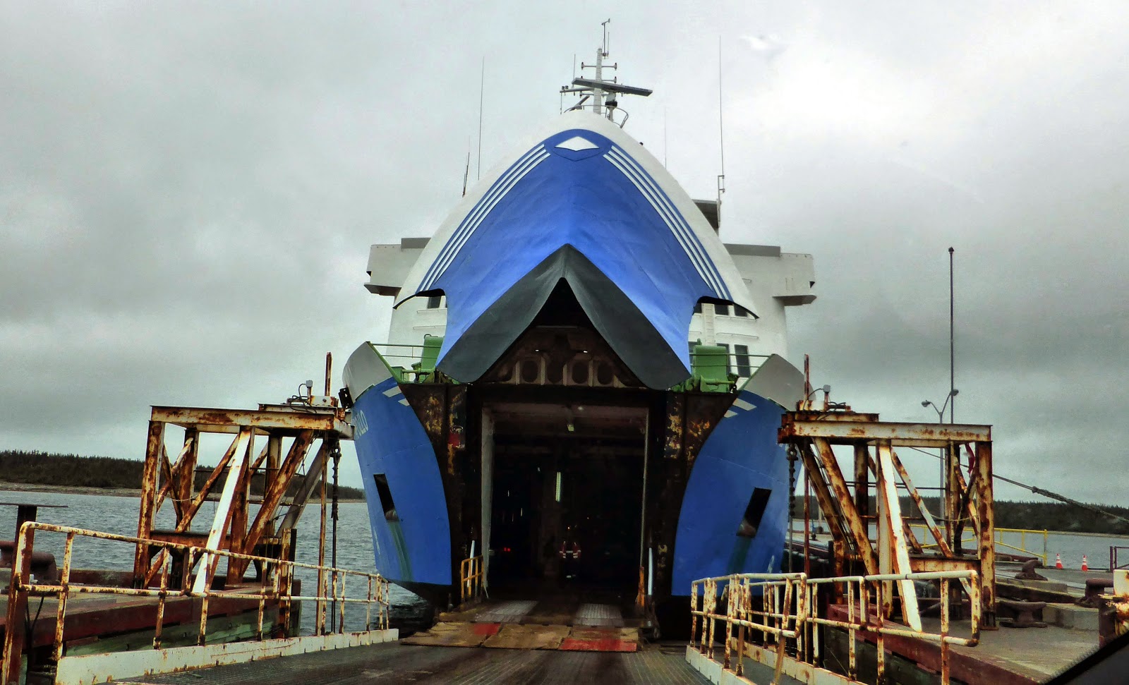
Apollo ferry
Ten minutes south of the fossils, we arrived in Saint Barbe, where we boarded the Apollo, the Labrador Marine ferry which would transport us across the Strait of Belle Isle to Labrador.  Originally launched from Germany in 1969, the 355-ft. ice-class vessel began service ferrying passengers and vehicles between Sweden and Finland.  This leviathan boasts a capacity of 1,200 passengers, 100 cars and eight tractor trailers.  After 30 years of service among a myriad of European countries from England to Finland, the ferry was purchased by Labrador Marine in 2000 and put into service between Newfoundland and Labrador.

Actually, the ferry made landfall in Blanc Sablon, Quebec, where we picked up the disconnected eastern fragment of QC-138, which took us the two miles to the Labrador border, hooking up with NL-510, the beginning of the fabled Trans Labrador Highway (TLH) and the Labrador Coastal Drive.  Two and a half miles into Labrador, we arrived in L'Anse au Clair (pop. 192), the first in a strand of coastal villages along the TLH as it strings its way up the Belle Isle shoreline.  French fishermen established these hamlets in the early 1700s, as home bases for their fishing concessions granted by Louis XIV (or XV) when this area was considered part of Quebec.

After checking in at the Northern Lights Inn in L'Anse au Clair (no Hilton or Marriott properties here), we continued our exploration northward—on the TLH, of course.  It was the only road available.  About halfway to Forteau (pop. 429), the next town, we spied a guy loading a float plane on a lake between the TLH and the strait.  Backtracking, we found a rutted road leading to the spot.

Load 'er up
Like all the other locals we have encountered in the province, John, the cargo crew/pilot, patiently interrupted his work to answer questions for us tourists.  He was loading supplies to deliver to a remote fishing lodge, where he would transport several fishermen from Toronto the following day.

Prior to 2010, John ran an active business shuttling people, mail, groceries, and other goods from Newfoundland to the more remote Labrador during the winter months when the ferry was unable to get across the strait.  But that year, a new section of the TLH was opened, finally connecting the south coast with central Labrador and stimulating an increase in vehicular traffic.

With a 96% subsidy from the federal and provincial governments, Labrador Marine began operating a winter (January through May) ferry service between Blanc Sablon and Corner Brook, a town farther south on Newfoundland island.  With a greater distance and angular path, pressure on the ferry from the strait's ice cover was reduced.  More often than not during these months, a Coast Guard ice breaker accompanies the ferry on its trek.  Last winter, a covering of ice 2 to 4 feet thick clogged 90% of the strait during the coldest months.

Ferry Apollo follows Coast Guard ice breaker across the Strait of Belle Isle (photo from LabradorMarine.com)
So now John is not so busy flying people and cargo back and forth across the strait in winter but manages to stretch out his summer fishing camp earnings over the cold months.  When we commented on how different his lifestyle is from the hectic and crowded pace of Atlanta, John replied, "Yes, I imagine it is.  But I love it here.  And I have a lot more freedom than you do, I'll wager."  We had to agree.

Ancient burial site (marked by those rocks)
Continuing up the TLH, we drove through Forteau and into L'Anse Amour (pop. 9), located on a pretty little cove and home to an ancient burial mound.  Identified as the L'Anse Amour Burial Site, this pile of rocks is recognized as the earliest known funeral monument in North America, marking the burial place of a child who died about 7,500 years ago.  Within the mound, archaeologists found a small stone burial chamber housing the well-preserved skeleton of a child with some accompanying artifacts including stone spearheads, a walrus tusk and a bone whistle.  The mound is part of a larger historic site which contains remains of many small seal hunting camps built by Maritime Archaic people between 9,000 and 2,000 years ago.

Point Amour Light Station
Just beyond the village on the unpaved road, we came in sight of the Point Amour Lighthouse.  Although roads are a late twentieth century development for most of Labrador, the lighthouse has been serviced by road since it was built in the1850s with lanes leading to two nearby communities with harbors where lighthouse supplies were offloaded.  Winding up a stone spiral staircase, we followed a young docent on a guided tour of the lighthouse.  A couple with twin seven-year-old boys comprised the remainder of our tour group.  These little rounders were bouncing up the stairs, full of energy and questions as we began.  By the time we reached the top of this lengthy climb, even they were flagging.

Model reveals counterintuitive building method with hardest material on inside.
As the model shows, the Point Amour lighthouse was built of limestone quarried nearby.  The limestone surface was covered with brick, and when the harsh weather began to tear at the mortar, a layer of clapboard was added as extra protection.


The lighthouse's 500-watt bulbs can project a distance of 30 miles with a boost from the fresnel lens surrounding the bulbs.  Only one of the four bulbs burns at a time, with another automatically rotating into service should the previous one burn out.

Remnants of the Raleigh
From the lighthouse, we suffered the blustery coastal winds to hike the Raleigh Trail, a grassy path curling its way to the shore and the rusted remains of the HMS Raleigh, victim of the strait's most famous maritime disaster.  The Raleigh was the flagship of the British navy's North American squadron when it was shipwrecked near the lighthouse in 1922.  Swerving to avoid an iceberg a mile and a half off shore, the ship ran into shallow water where rocks ripped a 360-foot gash into the hull, grounding it 200 yards from shore.  According to the lighthouse keeper at the time, the berg was the only one in the strait.

All but eleven members of the 700-man crew survived the catastrophe and made their way to the light station, where they were billeted in every square inch of refuge, including the stairs and landings of the lighthouse. A few years later, the British navy destroyed the shipwreck, leaving behind a few last vestiges of the Raleigh's final fateful voyage.

On the way back to the lighthouse, we found a perfect hiding spot for one of our "Love This Spot" letterboxes.  It's just off the trail and has a nice view of the lighthouse.  Then we called it a day, returning to our hotel in L'Anse au Clair with plans to continue our journey on the TransLabrador Highway the next day, no burden since we had only made it 15 miles up the coast.

West St. Modeste Lighthouse
Sunday morning dawned with partly cloudy skies and a temperature of 41°, reminding us that we have only two more days in this gloriously cool climate before returning home, where today's forecast calls for a high of 92.  Returning to the TLH, we zipped up to Point Amour to continue our coastal drive northward.  The next village was L'Anse au Loup (pop. 550) with a sandy beach and large fish processing plant. Then came West St. Modeste (pop. 120), home to a major French fishing operation in the 1700s.  Across 300-yard channel known locally as The Tickle, lies St. Modeste Island, a small, bare islet that is home to a comely 18-foot lighthouse that guides mariners safely into The Tickle.

Pinware River
A few more miles north we passed through Pinware (pop. 114) and crossed the Pinware River, known for salmon fishing and dense boreal forests.  Along the river, thick stands of conifers are interrupted by outcroppings of large granite boulders deposited by an ancient glacier.  Past the river, as we tracked onto a new section of the highway, the forest gave way to moss-covered tors with only occasional stunted evergreens.  Mosses and lichens added a variety of textures and color to the desolate landscape.

New section of 510 north of Pinware
At the end of the pavement, we arrived in the town of Red Bay (pop. 194), founded as the base for a major Basque whaling operation around 1550.  Exhibits at the Red Bay National Historic Site museum relate the story of Selma Barkham, a transplanted British historian, who theorized that coastal Labrador had once been a center of Basque whaling.  As an independent researcher, she combed archives in Spain and located historic documents bearing out her assumptions.  In the 1970s, under her guidance, Canadian archaeologists found well-preserved evidence, both on land and submerged in the harbor, proving that Red Bay had been one of the largest Basque whaling ports of the sixteenth and seventeenth centuries.

A 16th century chalupa boat recovered from the waters of Red Bay harbor
Beyond Red Bay, the TransLabrador  continues as an unpaved road.  Until its construction, a project begun in the 1990s, travel between communities in the Labrador Straits relied on boats in summer and snowmobiles in winter. North of Cartwright, a handful of widespread villages still have no road connections.  Because of the harsh winters and sparse population in much of the area served by the TLH, most of the highway is surfaced with well-packed gravel, which is re-graded in late spring each year.

Red Bay harbor
From Red Bay, the road continues north near the coast a further 50 miles before turning west to Happy Valley-Goose Bay, a 300-mile span of gravel away.  Beyond Goose Bay, the mostly unpaved road continues another 325 miles to Labrador City at the Quebec border.  For those who contemplate undertaking these long stretches through the vast wilderness of interior Labrador, the provincial government publishes a user guide with tips for survival.  Among the advice offered:
  • Bring at least two full-sized spare tires mounted on rims.    
  • Slow down when a vehicle passes you in either direction to reduce the chance of a rock cracking your windshield. 
  • Slow down when passing other vehicles to lessen the chance of striking them with mud or flying rocks.
  • Caribou often cross the road in large numbers.
The guide also offers this little dose of reality:
The road is narrow, has soft shoulders, high embankments, and steep hills. There are lengthy stretches of gravel surface with sharp rocks, potholes, washboard, and, depending on the weather, clouds of dust or slick mud.  Watch out for dangerous curves and loose gravel.  (User Guide for the TransLabrador Highway)
In fact, this part of Labrador is so remote that the provincial government offers a free satellite phone lending service because there is no cellular service along the TLH in this area.  Satellite phones are preprogrammed to call the Royal Newfoundland Constabulary, which will coordinate the appropriate emergency response.
     
Newly re-routed section of the TLH north of Red Bay
We drove just a few miles north of Red Bay to experience the rugged road.  Since the nearest town, Lodge Bay, was some 50 miles away and our rental car agreement nullified insurance coverage for such sections of the TLH, we dared not go further.  And besides, we wanted to dip down into Quebec, something which would have to be done today since we're booked on tomorrow's 8 a.m. ferry crossing back to Newfoundland.

Retracing our route down the coast, the TLH became Quebec Route 138 when we crossed the border into Quebec.  We were setting out on the far eastern fragment of this major route which traverses most of the province.  The Quebec government is in the midst of a massive ten-year project to build missing sections to complete Route 138 from Blanc Sablon to Quebec's border with New York State almost 1,000 miles away.  Between Old Fort and the current terminus of the western section at Kegaska lie the final 150 miles of challenging terrain to bridge.

Brador Falls, just south of Blanc Sablon
We drove southwest some 45 miles from Blanc Sablon to the end of the road at the unincorporated village of Old Fort, a ruggedly beautiful mostly uninhabited coastal drive.  Finally we headed back north to L'Anse au Clair to pack up for our morning departure from the big land, the beginning of the end of our trip as we return to Deer Lake for our flight out of the province.

SATURDAY, 21 JUNE - SUNDAY, 22 JUNE 2014
  
The ferry's wake
Vehicles load into the aft and exit the bow. 
Red Bay
TransLabrador Highway north of Red Bay

Up to the Cold North

Friday, June 20, 2014 Road Junkies 0 Comments

THE BIG CHILL, Chapter 8:  
IN WHICH WE LEARN THE TRUTH ABOUT 1492

Days 10 & 11:  St. Anthony

Nothing could have been easier than planning our route from Deer Lake to St. Anthony near the farthest edge of Newfoundland's Northern Peninsula.  We didn't even need the GPS.  Only one highway spans the peninsula—the 430, which hugs the coastline between the Gulf of St. Lawrence to the west and the Long Range Mountains to the east.  When we entered the address of our St. Anthony hotel into our Garmin GPS just for the heck of it, we were instructed to drive 258 miles and we'd reach our destination.  No risk of getting lost, which was great because we were driving in rain again.

Although Gros Morne is said to have the densest moose population in North America, we had not seen any of the massive creatures in our two days in the park—plenty of moose caution signs but no beasts.  Finally on the drive up to St. Anthony, we had our first sighting.  Fortunately he walked onto the highway well ahead of us, so we had plenty of opportunity to avoid hitting him.

CAUTION:  Moose crossing
As we would observe again later when we encountered other moose in the St. Anthony area, he seemed just as curious about us as we were about him.  He walked onto the road, stopped and looked at our car, no doubt wondering what that strange metallic white animal might be.  Then he lumbered on across to the other side and disappeared into the woods.

We had come to the northernmost tip of Newfoundland to check out evidence dispelling another myth we had been taught in elementary school—that Christopher Columbus was the first European to visit the North American continent.  (Of course if you're over 40, you were probably told that Columbus "discovered America," a continent already fully populated by native peoples, but we're not getting into that.)

Re-creation of a Viking sod longhouse
In 1960, Norwegian writer/explorer Helge Ingstad and his archaeologist wife Anne Stine found remnants of a Viking settlement on the far northern coast of Newfoundland near a fishing hamlet called L'Anse aux Meadows.  Archaeological excavation uncovered artifacts dating from around the year 1000.  Based on this evidence and old Icelandic sagas, historians speculate that Leif Erikson brought an expedition to this area seeking forests to provide wood to supply their shipbuilding needs in Greenland.  A temporary camp was set up at L'Anse aux Meadows and used as a supply station for a period of about ten years.

Interpreter at national historic site
In addition to the national historic site operated by Parks Canada, Norstead operates a commercial re-creation of a Viking village nearby.  Both offer Viking re-enactors in period costume at Norse sod huts, but they seem to co-exist harmoniously, providing needed employment for locals.  The national historic site also exhibits artifacts found in the excavation.

Norstead Village
When we arrived in L'Anse aux Meadows, the temperature was hovering in the mid 30s, the slate sky was spitting out a wintry mix of sleet and rain, and the wind was howling.  It was easy to see why this spot might appeal to Norsemen accustomed to the climate of Greenland and Iceland.

After our visit to the site of Mr. Erikson's compound, we explored the remainder of the northern coast.  With only three roads spidering out from the 430 artery, it was quite manageable to visit every village.  Along the way, we encountered four more moose, engaging in a staredown with each.

Who you lookin' at?
All around the northern peninsula, the roadsides are fringed with small rustic garden plots, often miles away from any residences.  Finally we spied someone working in one of these gardens and stopped to ask about this unusual sight.

Roadside gardens
Rocky, barren limestone dominates the coastal landscape.  As in much of the island, most of the topsoil was scraped away by glaciers in the last ice age.  Then in 1967, the government came through and built a highway.  In the process, backhoes churned up some rich peaty soil and bulldozers shoved it to the roadsides, creating a narrow band of land with soil deep enough to cultivate.

Working the soil on a cold day
Bonnie lives at the end of the road in Boat Harbor (pop. 55), about 45 minutes from her little garden plot, where she grows potatoes, turnips and sometimes carrots.  Her choice of crops is limited to those hardy, cold-tolerant plants with a short growing season. Even in mid-June, on a day like today, the temperature may not rise above 45°.   But that didn't stop Bonnie from braving the cold and wind to till her little plot.  Growing up and living her entire life on the icy northern coast of the Strait of Belle Isle, she's just as hardy as her crops.

Proudly flying the provincial flag
Up here at the top of Newfoundland, the folks are not just tough, they are fiercely proud of being Newfoundlanders.  At many of the homes we passed, the provincial flag flapped in the chill winds.  Icebergs floated offshore here at the head of the Strait of Belle Isle, where the Labrador Current drags the bergs from Greenland into the strait.

As in other parts of the province, the people of the Northern Peninsula have treated us warmly, always ready to stop what they're doing and talk to us or answer questions.  Tomorrow we will finally leave the Newfoundland part of the province, hopping the ferry across the strait to Labrador.

THURSDAY, 19 JUNE - FRIDAY, 20 JUNE 2014


A Good Morne-ing

Wednesday, June 18, 2014 Road Junkies 0 Comments

THE BIG CHILL, Chapter 7:  
IN WHICH WE SEARCH FOR AN 
ELUSIVE VIEW

Days 8 & 9:  Gros Morne National Park

Brilliant blue skies greeted us Tuesday morning as we left Deer Lake, driving north on Highway 430 toward Gros Morne National Park on Newfoundland's west coast.  We had built in two days for exploring this 700-square mile UNESCO World Heritage Site renowned for its unique geology and exceptional scenery.

Gros Morne National Park (photo from internet)
The park is conveniently bisected by the long reach of Bonne Bay, so our plan was to visit the southern section on Tuesday and head north the following day.  Though disappointed to learn there were no trail guides or even maps, we pressed on with our hiking plans Tuesday morning.  Tablelands Trail, a 2.5 mile stroll through gentle terrain, follows an old road bed through a barren orange/brown landscape with a Martian vibe.

Tablelands
Geologists say that millions of years ago, a collision between the African and North American continents shoved this expanse of the earth's mantle from the ocean floor to the land surface.  Its heavy iron content colors its appearance, while the lack of plant-sustaining minerals like nitrogen limit plant life.  At the terminus of this short trail, we planted our second letterbox in Newfoundland.

Green Gardens Trail
Tuesday afternoon we set off on the Green Gardens Trail from the Long Pond access, expecting we would scale the rugged 1,000-ft. hill and be rewarded with a view of the Gulf of St. Lawrence at the top.  Instead, the trail persisted in veering east across the face of the hill.  Finally, after almost two miles and still a long way from the summit, we decided to call it done.  The hour was getting late, and completing the loop would involve descending the other side to the shore, climbing back up and another descent to our car, or another four miles.  Though we enjoyed what we hiked of this much-hyped trail, in our estimation any number of trails in the North Carolina mountains offer a superior hiking experience in terms of scenery, variety and trail design.

Coastal Trail
Our last hike in Gros Morne was on the Coastal Trail Wednesday afternoon.  Skirting the Gulf of St. Lawrence, this four-mile return trail took us between the cobbled beach and a dwarfed tuckamore forest—stunted spruce and fir trees battered by the sea and wind.  Though the temperature never exceeded the 70s, we grew quite warm in the open sun until a helpful couple we met on the trail tipped us off about a shaded trail running parallel on the other side of the tuckamores, an escape that provided a welcome respite from the heat for the second half of the hike.

Trout River waterfront
Hiking and nature are only part of the Gros Morne appeal.  A series of quaint coastal villages, most with a population below 600, decorate the fringes of the park.  We have come to understand that calling a Newfoundland village picturesque is stating the obvious, an exercise in redundancy.  Effortlessly, these tiny hamlets exude a charm and comeliness that beg to be photographed or painted.  Dilapidated fishing huts convey an aura of history, not decay.

Woody Point Lighthouse
Woody Point is a perfect example.  Situated on Bonne Bay near Gros Morne's waistline, Woody Point is home to fewer than 300 souls.  From its winsome little lighthouse to the historic waterfront, Woody Point entices visitors to linger and savor the view.

At the Woody Point harbor, we chanced upon an exciting local event.  A fishing boat had just come in with the season's first catch of capelin.  When the waters grow warmer in June, billions of capelin, a small silvery fish, flock to the shallow waters around Newfoundland to spawn.  High tides carry the fish onto the shore where locals scoop them up in buckets or nets, an event known as the capelin scull.  Seeing this boat bringing in a catch offered the townspeople the frisson of knowing this year's scull won't be far behind.

Capelin catch!
During our two days at Gros Morne National Park, we failed to locate the vista pictured in the iconic GMNP photographs—the image used in all the park's promotional materials (the one at the top of this post).  Finally we asked a park ranger, "Where can we see that famous view?"  Without hesitation, not even needing to ask what spot we meant, he explained that this special point is located on the Long Range Traverse hiking route above Western Brook Pond, accessible only by way of a five-day hike.  Yes, five days.  Not five hours, five miles, or five kilometers.  Five days.  Never mind.

The two days we devoted to Gros Morne were well spent, even though we didn't—and won't—reach that special spot.  Tomorrow we'll continue up the west coast to St. Anthony and the site of a thousand-year-old Viking settlement.

TUESDAY, 17 JUNE - WEDNESDAY, 18 JUNE 2014

Tablelands Trail
Trout River
A private home in Woody Point
Lobster Cove Lighthouse