Big and Easy 'Boxing

Saturday, January 28, 2012 Road Junkies 0 Comments

TO BIG BEND AND BACK, Days 23-24
Lafayette, LA to New Orleans, LA 
    space
Whew!  We spent the final two days of this trip on a letterboxing marathon in New Orleans.  Having found most of the existing boxes in the Big Easy in December of 2010, we watched the Atlas Quest web site with growing interest as more and more boxes were listed in this fascinating city over the past year.  And then more.
    
A letterboxer who moved to the Crescent City from Florida planted the vast majority of the letterboxes.  Old New Orleans cemeteries were among his favorite locations for hiding these urban treasures.  Although we have visited some of these hallowed grounds before, we became much better acquainted with them on this visit.
    
Established in 1867, the Valence Cemetery was originally laid out for residents of a suburban village later annexed by New Orleans.  Valence houses a number of society tombs.  Professional and benevolent societies were very common in early New Orleans.  In addition to other services, these organizations administered to the burial needs of their members by providing mausoleum-like structures for the exclusive use of their organization (example pictured above).  Ethnic groups such as an old Italian Mutual Benefit Society also built society tombs in Valence.
    
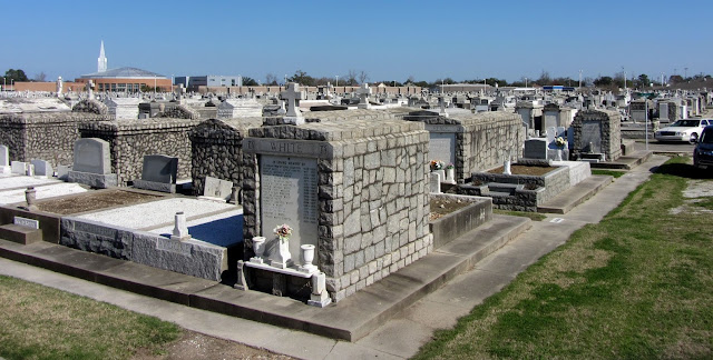
Owned by the city of New Orleans, Carrollton Cemetery dates back to 1849.  The graveyard was originally divided into sections for "colored" and "white." With the differing financial means available to each group, a distinct contrast can still be seen between the two, with mostly in-ground burials in the "colored" section and more elaborate tombs and markers in the "white" section.
    
Lest it appear disrespectful to search for letterboxes in these hallowed grounds, let us point out that the clues for these boxes gave very specific locations, down to pinpointing the x and y axis in photo clues.  When you looked at the picture in imaging software and identified the coordinates provided in this clue, you knew immediately to look in the bottom of the two stacked concrete blocks.  There's no willy-nilly turning things over, so nothing important is disturbed in the search.  We had not seen this particular strategy before but really appreciated the idea.
    
Holt Cemetery
Begun in 1879 as a burial place for the city's indigent, Holt Cemetery continues to serve the burial needs of those who cannot afford more expensive options.  For the cost of a burial, the plot is given to the family of the deceased as long as they maintain it.  As in most graveyards, some plots are well-tended while others are sadly neglected.  After Katrina drove so many residents from the city in 2005, many of these deceased no longer have local family members to take care of their graves.
    
Unlike other New Orleans cemeteries where most deceased are interred in above-ground tombs due to the city's shallow water table, Holt's graves are all underground burials.  And as is common in the city, multiple burials are allowed on the same plot.  Almost all markers and plot edgings are home made and bear tender sentiments of those who loved these people.  We were particularly saddened by the relatively young age of some of the deceased and wondered how their young lives had ended so abruptly.
    
Greenwood Cemetery

In 1852, when New Orleans was suffering through a national yellow fever epidemic, Greenwood Cemetery was established with more than 150 acres to provide a final resting place for many of the city's victims, numbering in excess of 8,000.  The city's first above-ground cemetery without walls, Greenwood was designed with minimal architecture and landscaping to maximize capacity.  In contrast to some other cemeteries we visited, Greenwood is meticulously maintained.
Treasure at Loyola University Law Library

In addition to our cemetery explorations, the New Orleans letterbox search also took us into several local libraries.  On a little-used shelf in a law school library, we found a book with a hollowed-out recess holding a set of 15 stamps.  Fitting the stamps together like the picture puzzle they were, we discovered a wonderful carving of the legendary gospel singer and New Orleans native, Mahalia Jackson.  Other clues led us from one section to another in a university library and into one of the city's public libraries.
     
By the end of two very full days in New Orleans, our letterbox find count had increased by 87.  Since our "normal" average when traveling is four or five boxes per day, this was a remarkable number.  Not surprisingly, this did not represent 87 different containers at that many locations, a feat which would require nonstop searching and stamping with no time for food or rest.  Our friendly local letterboxer seems to enjoy carving stamps much more than he likes seeking out clever hiding places for them.  His solution is to just add a new "box" (stamp and logbook) to the container where one of his other boxes already resides.  So it was quite common to find two, three or more "boxes" in one container.
     
We searched cemeteries, libraries, parks, church grounds, street corners, and businesses.  But by far the most unusual place we found some of these New Orleans treasures was on the grounds of private homes.  In the clues, the homeowners were described as "letterbox friendly" but wishing to enjoy their privacy while hosting these special repositories in their yards.  Our final stopping place of the second day was yet another home which we suspect to be the residence of the planter.  Rather than searching for a hidden cache, we found a stack of tupperware containers sitting in the open on the side porch.  Not much of a challenge, but the stamps were a nice reward, and the treasure in the chest can be increased any time of the day or night, whenever he finishes carving his latest masterpiece.
     
TRIP STATS
  • Days:  25
  • Miles driven:  4,670
  • States visited:  8
  • Letterboxes found:  186
FRIDAY, 27 JANUARY—SATURDAY, 28 JANUARY 2012

Texas, We Don't Get It!

Thursday, January 26, 2012 Road Junkies 0 Comments

TO BIG BEND AND BACK, Day 22
Katy, TX to Lafayette, LA 
    space
In 15 days driving around the great state of Texas, we never once forgot that we were in a unique and sometimes difficult to understand place.  In particular, we were often confused about the motivations and intentions of the Texas Department of Transportation, or whoever is in charge of road building in the state.  Just in case some Lone Star road commissioner ever reads this, here are our specific questions— five things we just don't understand about the Texas highway system.

1.  Why so many entrance and exit ramps?

For example, on Interstate 410 in the San Antonio suburbs, there is an entrance and exit every half mile or so.  Not only does this excessive merging introduce redundant risks for collisions, it restricts the length of ramps to unsafe conditions.

2.  What's the purpose of all the high speed one-way frontage roads?

Frontage road speed limit 65 mph
In so many Texas cities, even places as small as Texarkana, we have seen parallel frontage roads running beside the freeway.  We understand the concept of having these roads for local access, but when they are one-way roads with three to four lanes of vehicles traveling at 65 mph, it's equivalent to having additional freeway lanes and using them for local access is hazardous.

3.  Why promote wrong way driving?

An invitation for confusion
We were shocked to find that rather than offering dedicated entrance and exit freeway ramps, so many interstate access points are intertwined with two-lane roads.  Again, the ramps quite often provide a grossly inadequate distance for safe merging and the confusion in signage promotes accidental wrong way driving.

Last year more than 500 wrong-way drivers were reported in the San Antonio area alone.  We understand that the state is now investigating a wrong-way driving alert system.  How much easier to design roads that do not promote this problem!

4.  Why the obsession with flyover bridges?

Why the obsession with flyovers?
Yes, after driving in all 50 states, including California with its notorious traffic issues, we have certainly seen our share of flyovers.  But there seems to be an addiction to this highway design in Texas.  Even in areas with no apparent need, like in the middle of nowhere, rural, Texas where the bridge isn't even leading to a road, we have seen flyovers.  Too much money on your hands and looking for creative ways to spend it?

5.  What's the big hurry?

What's the big rush?
From our limited experience, drivers on Texas highways with an 80 mile per hour speed limit acted much like drivers on highways with lower limits; they drove 10 miles above the speed limit.  Yes, that's 90 miles an hour.  And when two-lane rural roads have posted limits of 75 mph ("slowing down" to 65 through small towns), the driving is just plain unsafe.  Yes, we get that the state is quite large.  It took us two weeks to get through it.  But maybe your residents and visitors would enjoy the state more if it didn't zoom past their windshields in such a blur.
     
THURSDAY, 26 JANUARY 2012

Katy, Bar the Rain (But Not the Door)

Wednesday, January 25, 2012 Road Junkies 0 Comments

TO BIG BEND AND BACK, Day 21
San Antonio, TX to Katy, TX 
    space
Yesterday's fog and gentle rain seemed but a sweet memory when we were startled awake before dawn this morning in San Antonio by a pounding thunderstorm.  As it moved east, this springlike weather system dipped into the Gulf of Mexico and dumped six to eight inches of rain across central Texas, hammering our plans to drive across the area today.
     
By the time we left San Antonio, the storm had moved out and blue skies held sway.  Having no desire to drive through torrential rain, we headed east and monitored the system, making sure we stayed behind it.  San Antonio was still visible behind us when we spied the edge of the front ahead.  As long as we played tortoise to its hare, we thought we might stay dry.
     
So we slowed our pace and poked along, stopping frequently to search for letterboxes.  In the town of Seguin, we were hit with solid evidence that we were not in west Texas any more.  All the dry, pristine letterboxes we came across in that arid climate were a thing of the past.  Two of the three letterboxes we found in Seguin were waterlogged.  In both boxes, the logbook had become saturated to the point of disintegration and the container was no longer in tact.  The first box we were able to rehabilitate by putting the stamp in a new container and adding a fresh logbook.  The second was a goner.  Even the stamp, which had been carved from an eraser, was crumbling.
     
Geronimo Creek near Seguin
Seguin also gave us our first look at the flooding left behind by the vicious weather system we were trailing.  Geronimo Creek was the first of many creeks we encountered that were swollen well beyond their banks by the excess rainfall.
     
San Marcos River
Near the town of Luling, the normally quiet and mild mannered San Marcos River had stormed into River Trail Park.  Luling promotes the river as part of the Texas Paddling Trail.  No canoeists braved this river trail today.
   
Getting close to the storm; better find another letterbox or two.
Thanks to the weather info on our GPS system, we were able to keep a constant watch on the storm system, speeding up to move along when it did, and stopping to search for a few more letterboxes when it stalled over Houston. 

Since Ken has an affinity for feral cats, the Bengal Tigers letterbox in Columbus, Texas, was a must-find for today.  The clues for the box told the story of a colony of feral cats that live in the city's Beason Park along the Colorado River (today, the raging Colorado River).  People in the town feed the cats and have even built houses for them.  At the park, we readily located the letterbox, which also needed major first aid, but the feral cats did not come out to see us on this cloudy day.  As chance has a way of compensating, however, we did see a herd of about six dozen white-tail deer running across a field next to the park.  What a treat!

Rather than our original destination of Beaumont, near the state line, we decided to call it quits for the day when we caught up with the storm in Katy, on the west side of Houston.  After 15 days in the Lone Star State, we'll move on to Louisiana tomorrow, weather permitting.
     
DAILY STATS
  • Weather:  Cloudy to Stormy, 55° to 67°
  • Miles driven:  231          (Trip total:  3,648)
  • States: 1 (TX)          (Trip total:  6)
  • Letterboxes found:  8         (Trip total:  92)
  • Creeks outside their banks:  13
  • Rivers taking over the neighborhood:  3
  • Soppy, goopy letterboxes:  4
  • Opportunities for wrong way drivers to enter freeway:  87
  • White-tail deer:  76    
WEDNESDAY, 25 JANUARY 2012

The back of the front

There's an App for That!

Tuesday, January 24, 2012 Road Junkies 0 Comments

TO BIG BEND AND BACK, Day 20
San Antonio, TX 
    space
Today dawned gray, foggy and rainy in San Antonio.  After the scheduled service on our car was completed at the local Acura dealer, we decided to take it easy for the rest of the day.

For lunch, we gave Romano's Macaroni Grill one more chance, primarily because it was close to the hotel and we had some coupons.  Macaroni Grill used to be one of our reliable favorites when traveling because the quality of the food and service was consistently excellent.  Recently they seem to be in a downward spiral.  Our last three experiences have been uniformly bad, resulting in two free meals and a couple of coupons for a free meal that we have yet to use because the meal today was comped.  Giving the managers credit, they always respond appropriately when we point out the poor quality of the food and/or service.  But just because a meal is free doesn't mean it's good.  So we're done with Macaroni Grill.  Anyone want $20 worth of Macaroni Grill coupons?

Although rain normally doesn't stop us from letterboxing, the traffic in San Antonio, America's seventh largest city, is frenetic, a quality that doesn't mix well with pea soup fog and pouring rain.  So we found a few drive-by boxes (close enough to where you park that you can grab the box and stamp in the car) and called it a day, making this the perfect day to talk about some of our favorite iPhone apps that make travel so much better.
     

The great thing about the convenience of being "connected" 24-7, of course, is that it makes so many things much easier and more convenient.  If there's a downside, it has to be losing touch with how to function without the gadgets.  But the world continues to move forward and so are we.  Some apps we use daily, even multiple times a day but these are the ones we use most often for our travel-related needs.

Where to Stay:
Once we decide on our destination, we depend on Trip Advisor to identify the best place to stay.  The many travelers who post reviews to this site don't mince words.  If there are bed bugs at a hotel, you don't have to find out the hard way.  Someone will have posted that nasty bit of news on Trip Advisor.  We have found the reviews to be quite reliable and wouldn't select a hotel without consulting TA.
Now that we know our desired lodging, we turn to the hotel apps to find a place to stay.  Of the three we use most often, Marriott is by far the best, making it very simple to schedule, review and manage our reservations.  Priority Club, the Holiday Inn family, is probably next best, and Hilton is the worst.

How to Get There:
In addition to our car GPS, we find ourselves using the iPhone Maps app, which employs the Google maps database.  Even though Google has a map app themselves, the iPhone app is far superior.  We especially find it useful for locating the nearest... whatever.  For example, we located the nearest Macaroni Grill with the Maps app.  That was a mistake, but it was easy to find.

Maplets helps us when we need a map of a particular place such as a national, state or local park, a college campus, or a subway system.  Our efficiency is increased if we don't have to track down a map when we arrive at a place.  It's great for situations like looking for a letterbox near the football stadium of a unfamiliar campus, for example.


Car Care:
When the tank is nearing empty, we need to find fuel.  Just like everyone else, we don't want to pay any more than we need to.  We turn to Gas Buddy to help us find the best gas prices near our location.  Normally we ask the app to sort the stations in order of price, but if we wait too late or almost too late, we can find the nearest station.

The oddly named Gas Cubby with the inexplicable woodcut icon is a vital tool for helping us monitor fuel usage and maintenance on the car.  We record all our gas fill-ups and can analyze the data by gas brand or octane rating to try to identify what's giving us the best mileage.  The data can even be exported and put into a spreadsheet to help with expense records.  We love that we can sync the data so both our phones have the same info.  (And we can store data for both cars on the app.)


Finding the Letterboxes:
In our pre-iPhone days, we had to plan well in advance where we would be letterboxing so we could identify letterboxes in the area and print the clues from the Atlas Quest web site.  Thanks to Clue Tracker, there's no more printing of clues.  It's all at our fingertips.  If we know we'll be in an area where we may not have cell reception, we can save the clues for that area within the app.  It even employs GPS data to allow us to "search nearby."  And the app draws on data from both of the primary letterboxing web sites.

On the frequent occasions when letterbox clues require us to follow a certain compass heading, we no longer need to dig the old compass out of our backpack and wonder whether it's functioning properly.  Our Compass app gives us the precise, reliable reading we need.  In fact, we have a more accurate reading so much faster, it probably increases the overall number of letterboxes we can find by... at least 0.5 to 1.0%.  Not to mention it's so much less annoying.

Finding Food and Drink:
What Trip Advisor does for lodging, Yelp does for food.  Although Trip Advisor has restaurant ratings as well as hotels, we find ourselves turning more and more often to Yelp for restaurant reviews.  We can search for the nearest restaurant of whatever type and check out what previous guests had to say about it.

Gasoline isn't the only fuel we need to find when traveling.  Ken loves a good bold cup of coffee and no one does that better than Starbucks.  Wherever we are, he turns to his Starbucks app to locate the nearest shop and fills up with his own brand of high octane.


How's the Weather?
Though Apple does a great job with most of their apps, we have found the weather app that came with the phone to be inadequate, since it provides only the forecast conditions and high and low temperatures for the day.  Shine is our weather app of choice.  It allows you to monitor conditions at any number of locations while automatically providing the forecast for your current location by using GPS data.  In addition to today's high and low, hourly forecasts are available as well as a look at the upcoming week.

These are our most treasured apps that enhance our travel experiences.  There are lots of other apps we use on a daily basis for communication, news, shopping, and a host of other needs. With more than a half million apps available for the iPhone, there truly is an app for almost anything and everything.

We had been talking about this today when I asked Ken what he wanted to do on this rainy San Antonio afternoon.  "There's a nap for that, " he replied.
     
TUESDAY, 24 JANUARY 2012

Ghosts in Texas

Monday, January 23, 2012 Road Junkies 0 Comments

TO BIG BEND AND BACK, Day 19
Del Rio, TX to San Antonio, TX 
    space
At last.  In Del Rio this morning, we found what we had sought in vain in Lajitas and Terlingua.  A commodity that is easily taken for granted, often not even considered, except when you desperately need it and can't locate one.  Yes, we're talking about an automobile vacuum cleaner.  We must have brought at least 40 pounds of grit with us from southwest Texas and finally this morning, we were able to shed most of the layers of grime inside the car.  Ahhh!  We can even breathe better without coating the inside of our lungs with dust.
   
Leaving Del Rio, we headed east on US-90.  Our first stop was in Brackettville (pop. 1,876) at the Seminole Indian Scouts Cemetery (pictured above).  The Black Seminole Scouts were descendents of Seminoles and free blacks or runaway slaves who made their way to Florida and lived with the Seminoles there.  The scouts were recruited by the U.S. Army to protect the Texas frontier settlers from hostile Native American tribes in the area.
   
During their service from 1873 to 1881, the scouts played a decisive role in the Indian campaigns, yet not one of their number (around 50) was killed or seriously wounded.  Four scouts were awarded the Congressional Medal of Honor for valor, and all four are buried in the Seminole Scout cemetery along with other scouts and their progeny.  Many of the descendents of these courageous men still live in southern Texas and northern Mexico.
   
But we want to see the village!
Another place we wanted to visit just north of Brackettville was Alamo Village, a complete replica of a western frontier town built for the filming of John Wayne's 1960 movie The Alamo.  The "set" has played host to more than 200 additional feature films, TV movies, mini-series, documentaries, commercials and music videos, including one of our favorite movies, the quirky Barbarosa, starring Willie Nelson as a legendary outlaw and Gary Busey as a green cowboy-wannabe.  But alas, our visit to the village was not meant to be.  We found the gates padlocked.   Unlike in the movies, no amount of shooting at the locks would remove them.  (Maybe we should have used something besides a camera.)
   
East of Brackettville, we passed another Border Patrol checkpoint.  The agent confirmed by inquiry that we were both U.S. citizens and waved us through.  Later in the little town of Knippa, we saw an agent standing on a tall platform next to the railroad tracks, visually inspecting rail car contents as a long train crept slowly past his watchful eyes.
   
One of many Border Patrol checkpoints
Just west of San Antonio, we detoured to the site of Old D'Hanis.  Established in the spring of 1847, D'Hanis was settled by 29 Alsatian families, some of the hundreds of families recruited to emigrate to the Republic of Texas by colonization agent Henry Castro.  The colony thrived, a post office was established, and, in 1869, St. Dominic's Church was built.

Quihi Gun Club
St. Dominic's Church
Though it flourished as a stage stop on the San Antonio-Rio Grande road, the town suffered when the railroad bypassed it.  In 1881, tracks were laid a mile and a half to the west.  Over the next few years, the businesses, citizens, and post office relocated around the train depot, an area which came to be called "New D'Hanis," and later simply D'Hanis.  All that remains of the old settlement are the church ruins and the cemetery.
   
Our last stop of the day was the Quihi Dance Hall at yet another Texas ghost town.  Also one of Castro's colonies, Quihi was the target of repeated attacks and eventually the town was disbanded in the 1880s.  However, the Alsatians and their descendents continued to live in the area.  In keeping with their European heritage, residents formed the Quihi Schuetzen Verein (later the Quihi Gun Club) in 1890.
   
More social organization than shooting club, the group has grown to more than 1,000 members across Medina County and most weekends the hall is the site of social gatherings.  Dances are held twice a month and draw participants from far and wide.  Unfortunately for us, there was no dancing at this tin building under the moss-draped ancient oaks on a Monday afternoon.
    
DAILY STATS
  • Weather:  PC to Sunny, 40° to 69°
  • Miles driven:  231          (Trip total:  3,413)
  • States: 1 (TX)          (Trip total:  6)
  • Letterboxes found:  4         (Trip total:  81)
  • Leaf-carrying ants:  892
  • Grumpy people in Brackettville:  4
  • Pounds of dust removed from car:  43 
MONDAY, 23 JANUARY 2012

Stamping in at a letterbox in Old D'Hanis

You Might Be in Southwest Texas if...

Monday, January 23, 2012 Road Junkies 0 Comments

You have a windmill pumping water somewhere on your property.

90% of the plants you encounter are armed with barbs.

You know the difference between a butte and a mesa, between an arroyo and a draw.

You drive for 280 miles and pass through only two tiny towns.

Most of the animals you encounter lick their lips and wonder if the human body is really 60% water.

Your closest neighbor lives across the river...in another country.

At every turn, you see vast unspoiled landscapes of beautiful natural scenery.

The biggest local employer is the U.S. Border Patrol.

Target is something to shoot at, not a place to shop.

You're tempted to use a leaf blower to clean the dust off yourself at the end of the day to reduce the  mud flow in the shower.

You have to drive 190 miles round trip to shop at a "real" grocery store.

The nearest Walmart is 200 miles away.

The speed limit is 80 miles per hour... in the school zone.

Land of the Pecos

Sunday, January 22, 2012 Road Junkies 0 Comments

TO BIG BEND AND BACK, Day 18
Lajitas, TX to Del Rio, TX 
    space
Reluctantly we left our Lajitas hideaway this morning and departed this little slice of tranquility.  Yes, we'll be glad to return to the land of reliable cell signal and internet connectivity, but our three-day sojourn in this tiny town provided a much-needed respite in our one-night stand wanderings.


Big Bend was our westernmost destination for this trip, so today we began our trek back east toward Georgia.  To reach the road that would take us north to US-90, we drove back briefly through the national park this morning.  Then it was up to the town of Marathon (pop. 430) where we searched for a letterbox devoted to that legendary south Texas cowboy, Pecos Bill, the folk hero star of numerous tall tales.

In Marathon, we picked up US-90 on its run from the Texas border to Jacksonville.  The Pecos Bill styled speed limit for this two-lane road was 75 miles per hour, except on the rare occasion when you ran through a town, where you were forced to slow to 70.  Some two hours and 120 miles later, we reached the tiny town of Langtry (pop. 145), most noted as the home of another Texas legend, Judge Roy Bean.

Though the town is a bit off the beaten path, the Texas DOT has established a Visitor Center and museum at the site of the Old West's most colorful justice of the peace, Roy Bean, who called himself "the law west of the Pecos." Books have been written about the unconventional style of justice that Bean dispensed from his saloon and billiard hall, which also served as his courtroom.
     
Styled the "Jersey Lilly" after Lillie Langtry, the British actress that Bean greatly admired, the building still stands on the same site today, part of the DOT facility along with Bean's home, which he called the Opera House.  Since there was no jail in Langtry, Bean's sentences usually required the convicted to pay a fine, most often the exact amount the culprit had in his pockets.  These fines were transferred to the judge's pockets, considered by him as his due for reducing lawlessness.

Judge Roy Bean trying a horse thief from his Jersey Lilly "court" in 1900
After locating the letterbox commemorating Judge Bean, we continued our westward journey toward Del Rio, our evening's destination.  Along the way, we encountered one last Pecos superlative, the Pecos River High Bridge.
     
Pecos River
High canyon walls dominate the last sixty miles of the Pecos River before it enters the Rio Grande. Several bridges had been built to span the river, beginning in 1923.  All close to the water, each of the bridges was ultimately destroyed by floodwaters until this 1,310-feet long highwater bridge was completed in 1957.  At 273 feet above the river, it has never been threatened by flood water damage.  Thus ended our visit to the Pecos, where the mythic "wild west" begins, the land that produced the legendary Judge Roy Bean and the fabled Pecos Bill.

DAILY STATS
  • Weather:  PC to Sunny, 40° to 75°
  • Miles driven:  300          (Trip total:  3,182)
  • States: 1 (TX)          (Trip total:  6)
  • Letterboxes found:  3         (Trip total:  77)
  • Coyote sightings:  1
SUNDAY, 22 JANUARY 2012

Lajitas Cemetery

On a Bender

Saturday, January 21, 2012 Road Junkies 0 Comments

TO BIG BEND AND BACK, Day 17
Big Bend National Park, TX 
    space
At long last, we entered Big Bend National Park this morning.  Big Bend refers to the great southwest dipping turn that the Rio Grande River makes in this area, defining the park boundary for 118 miles.  Covering 801,163 acres, Big Bend is one of the largest, most remote, and least visited national parks in the contiguous 48 states.  Across the river, adjacent Mexican territory enjoys a protected natural area status, forming a "sister park" with Big Bend.  And twelve miles to the west, Big Bend Ranch State Park, which enthralled us with its scenery yesterday, extends this preserve another 60 miles or so.

Our visit to the park began with a drive down Old Maverick Road, a 14-mile washboard dirt/chunky gravel track, headed toward Santa Elena Canyon, recommended as one of the most impressive areas of the park.  The landscape along Old Maverick was quite monochromatic, a warm yellowish beige, but the variety of plant materials and rocks rendered a canvas with luxurious texture.

Off Old Maverick Road (Santa Elena Canyon in distance)
Before we reached the canyon, we caught a glimpse of some type of animal scurrying across the road.  Stopping amidst the dust swirls stirred up by a half dozen motorcyclists roaring past, we were far too late to catch up with the mystery critter.  Fox?  Javelina?  We'll never know.

Approaching the floor of Santa Elena, the vegetation increased in frequency and variety thanks to the regular summer overflow of the Rio Grande at the canyon floor.  Like the other dozen or so tourists on site, we climbed the trail up the hill for a vertical view of the canyon's stunning vista.

Santa Elena Canyon (U.S. on right, Mexico across the river on left)
Near the top of our climb, we were startled when Ken's phone rang.  Cell service in this remote part of West Texas is as rare as cheap gas, and we almost fell off the side of the canyon from the shock.  It was one of our godsons, Max, whom we had tried to reach for his birthday yesterday.  As long as we stood perfectly still, we were able to sustain the signal for a brief visit with Max.  Only later did it occur to us that we might have been engaged in an inadvertent bit of international roaming off a Mexican cell tower.  We'll know the rest of the story when our next Verizon bill comes to call.

From Santa Elena, we took the Ross Maxwell Scenic Drive up through Castelon to the main road. Along the way we traveled through the geologic history of Big Bend.   

Cerro Castellan
Stacked in the layers making up Cerro Castellan is evidence of millions of years of volcanic events, lava flows piled on ash deposits with layers of gravel and clay amassing in between periods of eruptions.  Farther along the road, ash deposits are much closer to the road, creating a dramatic landscape of fudge-rippled contrasting colors.

Ash deposits on Ross Maxwell Scenic Drive
Tuff Canyon provides more geologic history and drama.  Tuff is a sort of compressed volcanic ash laced with hot rock and other material spewed out during an eruption.  And this tuff is really tough.  It's been around more than 20 million years.

Tuff Canyon
Our final destination in the park was the Chisos Basin.  The southernmost mountain range in the U.S., the Chisos Mountains are completely contained within Big Bend National Park.  Having risen up from the desert floor as we drove toward a cooler mountain habitat, we entered the tree zone as we reached the Chisos.

At the Chisos Basin Visitor Center, we encountered one of the local paisanos, the local nickname for the roadrunner, a bird often used as a symbol of the area.  This poor guy was running around the parking lot as I stalked him for a photo op.  Posted on a map inside the center were reports of mountain lion and black bear sightings, which had been frequent.  Those I would not chase after, even for a close-up shot.

Big Bend Paisano
From an elevation of less than 2,000 feet along the Rio Grande to nearly 8,000 feet in the Chisos, Big Bend encompasses rugged deserts, rocky canyons and forested mountains.  With so many scenic vistas, we found ourselves again lamenting our failure to bring Woodie to capture worthy photos of these picturesque panoramas.  Once, just after we called out to him, a phantom motorcyclist zoomed past us and we had to wonder, was it Woodie?

Woodie does love motorcycles...

ROAD NOISE
   
Rock toss.  While visiting Big Bend Ranch State Park yesterday, we commented that it was just a stone's throw to Mexico across the Rio Grande.  Of course, having said it we had to put that theory to the test.  Yep, it's a stone's throw away.
    
Sending this stone to Mexico
Are You Lost?  Today as we were sitting in the car picnicking at the Santa Elena Canyon overlook in the park, we had a big surprise when a couple of tourists stopped and tapped on the car window.  Our Georgia license plate informed them that we live in the same county they call home.  In fact, they live about three miles from the house where we used to reside.  (The reason we were picnicking in the car is that we forgot to bring enough food for the thousands of flies and gnats that wanted us to share.)
Not meant for minivans.  Big Bend has given us some opportunities to test the road worthiness (and off-road mettle) of our new-ish Acura.  On some of the steep inclines, Ken has found the paddle shifters that simulate manual transmission to be very effective in using the engine for braking and climbing power.  And it has handled well on some washed-out tracks we have negotiated.  (But we still miss the spaciousness of our old Odyssey.)
All wheel drive works.
DAILY STATS
  • Weather:  PC to Sunny, 43° to 75°
  • Miles driven:  132          (Trip total:  2,882)
  • States: 1 (TX)          (Trip total:  6)
  • Letterboxes found:  0         (Trip total:  74)
  • Flies and gnats in BBNP:  43,163
  • Roadrunner sightings:  2
  • Wile E. Coyote sightings:  0
  • Dusty motorcyclists in BBNP:  16
  • Travelers from our hometown:  2 
SATURDAY, 21 JANUARY 2012