Tuesday, May 15, 2012 Road Junkies 0 Comments

ON THE HISTORY HIGHWAY: EPILOGUE
March 15-May 14, 2012
     
We couldn't have selected a better area of the U.S. for a history-seeking journey.  Since our agenda included all 13 of the original American colonies, our paths constantly took us to places significant in the early history of our country.  Moreover, almost three-fourths of Civil War battles were fought in the states we visited.  We were consistently impressed with the work that preservationists at all government levels, as well as philanthropists and volunteers in the private sector, have done to ensure that generations to come will have the opportunity to find these hallowed grounds much the way they were when they were at history's center stage.  (No, Williamsburg, that does not include you!) 
    

Since we've been home, we've put together some final trip statistics and a few "bests and worsts" of our History Highway trip.   After chasing it for 60 days, we have concluded that 
History Never Gets Old.

••••••••••••••••••••••••••••••••••••••••••••••••   

Trip Stats
  • Days: 61
  • Miles traveled: 6,800
  • States visited: 18 + DC
  • Letterboxes: 224 found, 12 planted
  • Walked: 114.43 miles
  • Family members visited: 17
  • State Parks:  34
  • Forts:  24
  • Museums: 57
  • National Parks:  1
  • National Historic Parks/Sites: 15
  • National Battlefields:  7
  • Presidential Birthplaces:  4
  • Presidential Graves:  6
  • Cannons:  4,916
  • Bugs on our windshield/grill:  92,163
  • Woodchucks:  12
  • Ticks:  6
  • Snakes:  4
  • Road kill:  83
  • Pollen spores:  235,109,471,347,382
  • Kids on spring break:  193,522
  • Highest gas price:  $4.30, Arlington, VA
  • Lowest gas price:  $3.54, Blacksburg, SC 
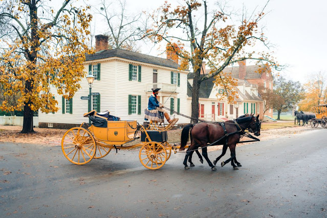
Williamsburg, VA, the authentic colonial town with asphalt streets

Plymouth Rock:  Did Pilgrims see this stone and sail their ship toward it?

Certain historical figures crossed our path repeatedly.
We spent 2 weeks in Washington, DC, and could have stayed longer.
Worst Cities
  1. Manchester, NH
  2. Manchester, NH
  3. Manchester, NH
  4. ETC.
Favorite Cemeteries
  • Arlington National Cemetery (Arlington)
  • Hollywood Cemetery (Richmond)
  • Christ Church Burial Ground (Philly)
  • Burial Hill (Plymouth)
  • Old City Cemetery (Lynchburg)
Army caisson procession in Arlington National Cemetery
Independence Hall, Philadelphia 
Best Historic Sites and Museums
    (in random order, too close to rank) 
Max Patch Mountain, NC:  site of the first US letterbox
     space  
Most Memorable Letterboxes
Places We Should Have Skipped
Surprises

     space  
Best Meals
Worst Meal
Recurring Historical Figures

Both intentionally and accidentally, we repeatedly came across sites related to these men. 
  • Edgar Allan Poe
  • John Wilkes Booth
  • George Washington 
  • Abraham Lincoln 
  • Robert E. Lee
  • Stonewall Jackson 
Misery on the George Washington Bridge, NYC 
Not Our Favorite Days
space  
space  
Best Days
And the Rest
  • Most overpriced:  Colonial Williamsburg
  • Best value: Washington's free museums
  • Next best value: National Park Pass ($10)
  • Best rest areas: Virginia
  • Best hotel: Hampton Inn, Exeter, NH
  • Worst hotel: HI Express, Brattleboro, VT
  • Best breakfast: Hilton Garden Inn, Saratoga Springs
  • Most embarrassing moment: Amish stalking
  • Worst teeth: President Wilson
  • Biggest tick:  2 wood ticks on Dianne's scalp 
  • Sorry we missed: Boston & New York
TUESDAY, 15 MAY 2012
space
space

space

Winding it Down

Monday, May 14, 2012 Road Junkies 0 Comments

ON THE HISTORY HIGHWAY, 
Days 59-61:  Danville, VA to Home
     
Since we were staying very close to the North Carolina border in Danville, our first priority before leaving the commonwealth on Saturday was finding a place to hide our Virginia letterbox.  Danville had plenty of boxes, so we decided to look at Martinsville, the nice town where we purchased our old Honda Odyssey.  Unfortunately, neither of the parks we checked was a good match, nor was a local cemetery.

Meanwhile, I discovered that another wood tick had invaded my scalp.  We had learned something from our experience a couple of days ago and this time we used an alcohol-drenched cotton ball to knock him out.  Ken held the cotton ball against the tick with a little pressure for about 30 seconds.  (Think of the old ether-soaked rag held over a victim's face in vintage movies.)
           space  
This method seemed to work much better, and the beastly critter released.  This time instead of tweezers, which make it difficult to grasp the tick without pulling out a clump of hair with him, Ken used a fine-tooth comb to elevate the little monster away from his food supply.  Once we were done removing the second tick in three days, it finally struck us that the hitchhiker letterbox we picked up in Sharpsburg just might be the cause of our invasion.
     
After this, we sort of lost our enthusiasm for hitting the trails for either finding or hiding letterboxes and decided we could slip into Virginia to plant this box when we go to the North Carolina mountains in August.  We filled up the car with gas, tuned the radio to Car Talk, and set the GPS for Charlotte.  After checking in at the hotel, we visited Ken's mother, Erika, who served us a wonderful dinner, and made plans for Mother's Day.
     
Though it's only a couple of hours from Charlotte, Greensboro was a bit too far for Erika to make the trek on her own to check out her daughter Marion's new home.  So we had the opportunity to not only make the visit possible but also to include Erika's friend Anita in our Mother's Day celebration.
     
Marion and Heather prepared a wonderful Mother's Day meal, with help from Emma and Ryan, and we thoroughly enjoyed our time together before we drove Erika and Anita back to Charlotte in a steady rain.
     
On Monday, we had an uneventful trip back to Georgia, arriving home a little after 3:00.  After a stop at the post office to pick up two months' worth of mail, we headed for home and hearth.   Another trip completed.
space  
     
SATURDAY, 12 MAY—MONDAY, 14 MAY 2012

More History Through Letterboxing

Friday, May 11, 2012 Road Junkies 0 Comments

ON THE HISTORY HIGHWAY, Day 58
Fishersville, VA to Danville, VA 
       
After discovering last night that we were only seven miles from a Presidential birthplace, we had no choice but to drive to Staunton (pronounced STAN-ton) this morning.  On December 28, 1856, the local Presbyterian minister and his wife welcomed their third child and first son.  Born at the manse, the home provided to the family by the church, Thomas Woodrow Wilson was named for his paternal grandfather.  Called Tommy as a young boy, Wilson dropped his first name after college, preferring the more distinctive sound of Woodrow Wilson.
     
Wilson's family headed to Georgia when little Tommy was one year old, and the new minister and his family moved into the residence.  This continued with each new personnel change until Wilson was elected president in 1912.  After people learned that he had been born in this house, curiosity seekers would knock on the door night and day asking for a tour of the house.  Finally, the church built a new ministerial home and a local group in Staunton purchased the Wilson birthplace (pictured above) to be used as a museum.  An animated local resident provided an entertaining guided tour of the house, which is furnished as it would have been in 1857 when it was young Tommy's home.
     
One of the more interesting items on display in the museum next door was the 1919 Pierce-Arrow, which was Wilson's favorite car.  An early automotive enthusiast, Wilson liked to take daily rides in the car when he was President.  Since this was the day before convertibles, the car came with two bodies, the enclosed sedan pictured here, and an open touring car, which Wilson preferred.
     
President Wilson's 1919 Pierce Arrow
Hidden by a flag in this photo is a chrome AAA logo, which was mounted to the grill, a symbol of Wilson's membership in the fledgling American Automobile Association.  His membership card was also on exhibit.  
     
Given his characteristic solemn expression, a photo of the 28th President smiling was the most surprising item on exhibit in the museum.  Wilson was attending a baseball game with his second wife Edith during his second term of office and was photographed smiling (sort of) at the game.  Of course, that sparked our curiosity about why Wilson always seemed to look so grim.
     
President Wilson (photos from Library of Congress)
A bit of research revealed that Woodrow Wilson suffered significant dental problems.  The candid photo on the left was taken on his inauguration day in 1913.  The photo must have convinced him that a closed-mouth expression when being photographed was preferable.
     
After visiting the very interesting Wilson site, we started making our way south toward Danville.  With no letterbox finds yesterday, we decided to make up for lost time.  Our first find was at a local restaurant in Staunton, where we picked up a piece of letterboxing pie.
     
Just to the east near Afton, we cautiously visited a scenic overlook off I-64, where a couple and their dog survived a 2005 accident that sent their SUV plummeting end over end more than 200 feet down the side of a mountain after the vehicle struck a guardrail.  Since no one was seriously injured, the incident was perfect fodder for a letterbox, hidden at the overlook.
     
Our search for the next box on our list took us to Woods Mill in Nelson County.  After hunkering down in a Mobile, AL, college dorm in 1969, as Hurricane Camille approached and then dodged the city, I was very surprised to come across a letterbox related to that legendary storm in Virginia.
     
Having seen the destruction Camille wreaked when she made landfall on the Mississippi coast, I was startled to learn that two days later, the same storm was responsible for one of the worst natural disasters in Virginia history.  Nine hundred miles from the Gulf coast, Camille pulled in moisture from the Atlantic and dumped 27 inches of rain on Nelson County, an amount described by the National Weather Service as "the probable maximum rainfall which meteorologists compute to be theoretically possible."  The letterbox had gone missing, but taught us some interesting history.
     
In the hamlet of Lovingston, we located three clever letterboxes before moving on to Lynchburg, home to a wealth of boxing opportunities.  After finding a brilliant letterbox at 801 Main Street, we moved on to other areas of the city.  On the Randolph College campus, we were looking for a letterbox when we came across...(shhh)...Project Y.
     
Project Y, now known as Maier Museum of Art
In 1951, during the Cold War, the campus was chosen as the location of a confidential storage facility, code named Project Y, to be used by the National Gallery of Art in the event that a national crisis threatened the safety of its collection.  In exchange for ownership and eventual use of the specially designed reinforced concrete building, the college agreed to make it available for emergency use by the gallery for 50 years.  Never used for its intended purpose, the building today serves as the college's art museum.
     
The last stop in our letterbox-driven tour of Lynchburg—and certainly the most surprising was the Old City Cemetery.  As many fascinating cemeteries as we have visited while letterboxing, we found this one completely unique.  Established in 1806, it is one of the oldest public cemeteries in continuous use in the U.S.  But the 22,000 people buried there are only part of the story.
     
The cemetery is also home to five small museums, an antique rose garden, a lotus pond and butterfly garden, a medicinal herb garden, and a dovecote.  For those who choose cremation, the cemetery has set aside a special place to scatter the ashes of the dead.  And when a beloved animal dies and is cremated, the ashes can be scattered within a special pet scatter garden on a bluff overlooking the pond, chapel, and dovecote.  The entire complex was quite remarkable and we were glad someone planted letterboxes to lure us there.
     
Finally and reluctantly we departed Lynchburg for Danville, getting into our hotel after 7 p.m.  With 13 finds, we considered it a productive letterboxing day.  Tomorrow we head to Charlotte for a Mother's Day visit with Ken's mom.

FRIDAY, 11 MAY 2012

Memorial Dovecote at the Old City Cemetery

Now We're Ticked

Thursday, May 10, 2012 Road Junkies 0 Comments

ON THE HISTORY HIGHWAY, Day 57
Strasburg, VA to Fishersville, VA
    space
Our 39th wedding anniversary dawned sunny and clear.  With no particular historic destination on the agenda, we decided to venture away from I-81 and drive down the scenic Skyline Drive (pictured above) in Virginia's Shenandoah National Park.  The road follows the crest of the Blue Ridge Mountains for 105 miles.  As we discovered once we arrived at the park, it was indeed historically significant.
     
From the time when Yellowstone became the world's first area designated as a national park in 1872 through the 1920s, the national park movement in the U.S. had been a western phenomenon.  Not only did the West boast an abundance of spectacular natural scenery, much of the area still existed as federally owned territories, making park designations a simple matter.  Maine's Acadia National Park, founded in 1919, was the only national park east of the Mississippi.
     
Since long-distance travel during this period was impractical for most Americans, the park system needed to gain a foothold in the East to benefit more citizens.  Eastward expansion would also generate greater Congressional support for the park service.  So in 1926, Congress authorized three eastern parks:  Shenandoah, Great Smokey Mountains, and Mammoth Cave.
     
Shenandoah National Park
When we decided to change our course and drive through Shenandoah, we realized that the letterbox clues we had saved for our trip down the interstate would be useless.  No problem, with our handy Clue Tracker app.  In an attempt to search for letterboxes on our route, however, we stumbled upon an unpleasant surprise.
     
Atlas Quest, our primary database source of letterbox clues, had been hacked this morning.  Aargh!  We were confident that the site would be restored but not sure how long that would take.  We'd just have to keep checking.  As it turned out, even connecting to the internet with our smartphones turned out to be a challenge, as cell service through the mountains was quite spotty.  Often, we'd have voice service but no data.
     
Shortly after entering the park at Thornton Gap, we stopped at a comfort station, where we chatted with an Appalachian Trail thru-hiker from Lancaster, PA, who said he planned to cover 30 miles today.  Since the AT follows the same ridge as Skyline Drive, crisscrossing with the road, we would see it often today.  With an entry point near the station, Ken decided to take a little hike, but I declined.  The cool, breezy weather we encountered when we left our hotel in Strasburg had turned downright cold and blustery. Ken bundled up, pulled on a ski cap, and took off for a 30-minute sampling of the AT, while I cozied up in the car, still trying to connect with AQ for some letterbox clues.
     
A taste of the AT
Arriving at the Big Meadows Visitor Center around noon, I was able to grab enough of a signal to see that the "Under Construction" page was up on the AQ web site.  At least the creepy eyes were gone, but still no letterbox clues were available.  The wind was still whipping, so I grabbed Ken's ski cap to keep hair out of my face when we got out of the car.  This turned out to be a mistake.  Apparently that cap had picked up a little hitchhiker while Ken was on the AT earlier.
     
Evicting an unwanted guest
An hour later, as we were driving down the parkway, I touched a place on my scalp that felt itchy.  Warning Ken that I thought I had picked up a tick, I asked him to stop at the next pull-off.  Sure enough, Ken found a chunky wood tick cozied up in my scalp and taking a deep drink of my blood.  Since we more often encounter the much smaller deer tick, we had a bit to learn about the larger wood tick.  Our usual removal method of saturating the tick with an alcohol-drenched Q-tip until it releases wasn't having much effect on this big guy.  Nor did pouring alcohol on him meet with much success.  Ken finally tweezed it off while it was still gripping, taking a little patch of my scalp with the monster.
     
That unpleasant task behind us, we continued down the parkway.  Spread out along the course of Skyline Drive are 75 scenic overlooks.  Quite a few of the overlooks we passed today were closed for construction.  Signs proudly proclaimed that the work was made possible by the American Recovery and Reinvestment Act. 
     
It seems that we taxpayers gave the park service a $17 million grant for "rehabilitation" of 16 Skyline Drive overlooks and other projects in the park.  If the work is actually needed, we certainly don't object to this particular use of federal funds.  However, what we observed was the removal and reconstruction of rock walls at these overlooks.  Strangely, all the existing rock walls we saw, many of which were constructed as part of Roosevelt's economic recovery stimulus in the 1930s, still appeared to be quite stable and strong.  Admittedly, we didn't see the walls before they were removed, but if they looked like the ones we observed, the need for "rehabilitation" is a mystery.
     
Another gem administered by the National Park Service is the Blue Ridge Parkway.  Though we've driven on this beautiful road many times in the North Carolina mountains, we never considered the location of the northern or southern terminus.  Today we found out.
     
Begun in the Depression era as a relief project to provide work for the unemployed, the Blue Ridge Parkway connects Shenandoah National Park in Virginia with Great Smoky Mountains National Park in North Carolina.
     
Our mountain-top journey done for the day, we exited the scenic highways and headed to our hotel in nearby Fishersville, VA, discovering when we turned on the computer that the Atlas Quest web site was back up and running. What a nice anniversary gift!
     
QUOTE OF THE DAY
"He was big, bad, and nasty.  A beast!"    
Ken, about the tick he removed from my head
     

THURSDAY, 10 MAY 2012

Carnage in a Cornfield

Wednesday, May 09, 2012 Road Junkies 0 Comments

ON THE HISTORY HIGHWAY, Day 56
Hagerstown, MD to Strasburg, VA 
    space
After searching for a couple of letterboxes in Fort Frederick State Park near Hagerstown, we drove east to Boonsboro to visit Washington Monument State Park.  No, that is not a typo.  And no, we're not talking about the 555-ft. obelisk on the Washington Mall.  That tribute wasn't even begun until more than twenty years after the one we visited today was completed.
     

According to a contemporaneous newspaper account, the citizens of Boonsboro, MD, decided in 1827 to build a monument to the young nation's first president.  This was a grassroots effort, and on July 4 of that year, most of the town's citizens assembled behind an American flag and paraded with a drum and fife corps to the summit of nearby South Mountain.  Using granite stones found on site, the citizens worked until noon and then held a dedication ceremony. They resumed work and by 4 p.m. the monument stood 15 feet high on a 54-foot circular base (pictured above). The day ended with the reading of the Declaration of Independence and a three-round salute fired by Revolutionary War veterans. Workers returned in September to finish the monument which stood 32 feet high upon completion.  Today, as then, visitors can climb to the top for a great view of the valley below.  (For some strange reason, we left there thinking about a nice glass of milk.)
    
"Find the large flat rock."
Before leaving the area, we talked to some hikers and took a short walk on the Appalachian Trail, which traverses the park.  Off the trail, we found a couple of letterboxes, including one which asked us to find the "very large flat rock" in an ocean of granite.  We were quite astonished when we actually uncovered the letterbox.
    
From Boonsboro, we drove ten miles to Sharpsburg to visit Antietam National Battlefield.  As in Gettysburg yesterday, we found the parking lot at Antietam pretty full.  Based on our positive experience with advice from a savvy ranger at Saratoga National Historical Park and our limited time, we asked one of the park rangers to point out the top priority sites on the driving tour.  He cited the cornfield, sunken road, and lower bridge, the three areas that were the centers of fighting during the battle, so those are the places we visited.
    
On September 17, 1862, more than 23,000 were killed or wounded at Antietam, the bloodiest single-day battle in U.S. history.  The First Texas Infantry lost 82% of their men killed, wounded or missing while fighting in Miller's Cornfield, the highest casualty rate for any Confederate regiment in one battle of the Civil War.
    
From dawn to 9:30 a.m., a storm of lead, iron and flame flew across a Maryland cornfield, as 27,000 troops engaged in a fierce battle.  By the end of fighting, more than 8,000 lay dead or dying.  Union General Hooker described the scene:  "Every stalk of corn in the northern and greater part of the field was cut as closely as could have been done with a knife, and the slain lay in rows precisely as they stood in their ranks a few moments before.  It was never my fortune to witness a more bloody, dismal battlefield." 
      
Sunken Road at Antietam
After the morning of slaughter at the cornfield, the battle moved to where the middle of the Confederate line was anchored on a track that locals called Sunken Road.  By the end of the day, this strip was known as "Bloody Lane," the site of an intense four hours of brutal fighting.
     
The third and last phase of the battle focused on the efforts of a greatly outnumbered Confederate force to hold onto a bridge that spanned Antietam Creek. Their success in delaying the Union capture of this critical junction allowed Confederate reinforcements to arrive from Harpers Ferry.  This addition to the Southern force, coupled with Union commander McClellan's errors in judgment, resulted in a stand-off at the end of the day.  The following day, with no clear victory for either side, Lee withdrew his army back into Virginia.
     
Confederate soldiers near Dunker Church  (image from Library of Congress)
Antietam was the first American battlefield photographed before the dead were buried, and the graphic images shocked the nation and the world.  The photo here of dead Confederate soldiers and a crippled artillery limber was taken by Alexander Gardner two days after the battle.
     
Battlefield Monument
In the midst of dozens of formal and traditional granite monuments on the battlefield was an unusual but meaningful tribute to Pennsylvania soldiers who fought at Antietam.  The inscription reads:  "Here fought the 90th Penna. (Phila.).  Sept. 17, 1862.  A hot place."
     
In an odd twist, we saw the park service implementing the flip side of restoration work we encountered at the Vicksburg (MS) National Military Park in January.  Whereas a large section of the Mississippi park had been deforested to restore it to its condition at the time of that battle, trees have been planted at Antietam in an effort to re-establish the forest which flourished here in September, 1862.
     
Our last major stop of the day was at Harpers Ferry, WV, just 14 miles from Antietam.  When we arrived, we tried to locate a tri-state marker at this spot where Maryland, Virginia, and West Virginia meet, but all the locals we asked said there wasn't one.
     
Harpers Ferry
Standing at the crossroads where the Potomac and Shenandoah Rivers meet before crashing their way through the mountains, Harpers Ferry has been the scene of many historic events.  In 1796, President Washington persuaded Congress to establish a federal arsenal and weapons production facility in the town, the genesis of its expansion and, later, of its destruction.  In 1803, the armory supplied Meriwether Lewis with weapons and other items his expedition party would need for their exploration of the newly acquired Louisiana Territory. 
     
Firehouse used as John Brown's fortress
     
Fifty-six years later, in 1859, the radical abolitionist John Brown led a group of 21 raiders in an attack on the armory, hoping to capture weapons to be used in a widespread slave uprising.  Local militia penned the invaders in the armory's firehouse until U.S. Marines, under the command of Lt.Col. Robert E. Lee, arrived and captured Brown and his followers. Since this infamous event, the building has been vandalized by souvenir seekers, dismantled, taken on tour, and moved four times, before it was finally re-situated within 150 feet of its original location by the National Park Service in 1968.
     
Made desirable because of its armory, Harpers Ferry changed hands several times during the course of the Civil War.  Each time an occupying army left the town, fires were set to keep weapon-making capabilities out of the hands of the other side.
     
By the end of the war, what had been a prosperous town was a ghost of its former self.  Many years of rebuilding were needed and the town was never the same.  In 1944, most of the town became Harpers Ferry National Historical Park.  Since then a few businesses have grown up to serve tourists and outdoor enthusiasts who come to the area for such activities as rafting and rock climbing.
     
With its location near the midway point of the 2,181-mile Georgia-to-Maine Appalachian Trail, Harpers Ferry is home to the AT Conservancy, which coordinates maintenance and protection of the trail, as well as education and awareness activities.  Harpers Ferry is one of only a few towns that the trail passes through.

Appalachian Trail goes up the stairs.
Part of the path the trail takes through the town leads up a set of stairs past an old church, and uphill to Jefferson Rock overlooking the river.  While up in the area near the rock, we planted our West Virginia letterbox before leaving the town and the state.  Rain followed us all the way to Strasburg, VA, our stopping place for the night.
     
WEDNESDAY, 9 MAY 2012

Three Days in July

Tuesday, May 08, 2012 Road Junkies 0 Comments

ON THE HISTORY HIGHWAY, Day 55
Hanover, PA to Hagerstown, MD 
     
Although this trip has been about seeing sites related to U.S. history in general, because of the area we've traveled, we have visited many locations related to the Civil War.  So it was fitting that we include Gettysburg, PA, on our agenda.
     

When we arrived at the visitor center at Gettysburg National Military Park, we found a ticket concession selling admission to a tour, museum, and/or cyclorama.  Hmmm.  We started at the gift shop to stamp our National Park "Passport," where we were amazed at the array of items for sale, including $4,000 replicas of Robert E. Lee's field desk, made with wood from "battlefield trees."  There were also hiking sticks made with wood from "battlefield trees," even specifying whether the wood came from a Confederate or a Union field position.  Wait.  This is a national park gift shop?

We were a bit confused.  So we headed to the desk with the INFORMATION sign.  There we met a friendly U.S. park ranger.  "What about our NPS pass?" we asked.  "Does it gain us admission to anything here?"
     
"The lobby," he replied.  Then he informed us that the NPS has partnered with a private vendor to operate the various activities at the site.  However, he did offer to usher us through a back door to the museum, and we happily accepted.
     
Two hours later, we left the excellent museum after seeing only a tiny portion of the park's more than one million artifacts from the Battle of Gettysburg.  The museum's interpretation of the battle provided an informative context of its importance within the war and in the broader picture of U.S. history, as well as detailing the events of the battle in archival documents, arms, and relics from the battlefield
     
In three days of fighting at Gettysburg, about 7,000 soldiers and 3,000 horses died on the battlefield—almost three times the population of the town.  More than 25 square miles of ground were littered with bodies.  No one present had ever seen death on such a scale. 
     
Gettysburg was the deadliest battle of the war.  "We could not open our windows for weeks because of the horrible stench," one Gettysburg resident was quoted as saying.  An exhibit at the museum puts faces to the names of some of the Americans who were killed in the battle.
     
Furnishings from Lee's HQ tent
The stove, cot, medical chest and field desk that traveled with General Robert E. Lee during the invasion of Pennsylvania are among the many artifacts on exhibit at the museum.  Lee's modest headquarters did not reflect his importance to the Southern cause.  In contrast, General Meade, the Union commander at Gettysburg, set up his HQ in a local farmhouse.
     
An entire room of the museum was devoted to Abraham Lincoln's acclaimed "Gettysburg Address."   While the speech through the lens of history is praised for its classical elegance and heartfelt emotion, it was roundly criticized for its brevity and "inappropriateness" by some newspaper accounts in the days after it was delivered.
     
Relics at The Horse Soldier
By the time we left the museum, rain was steadily falling.  After checking out and rejecting the visitor center restaurant, we went to the car and put together an automotive picnic of peanut butter sandwiches and a small bag of chips (something we rarely eat, purchased at the visitor center for $1.59).
      
Then we walked in the rain to the Soldier's National Cemetery where that 10-sentence, two-minute speech was delivered.  Although the visitor center was crammed with more than 500 tourists, only three other people were strolling in the foot-traffic only cemetery on this rainy day.
     
We continued our Gettysburg visit with part of the 24-mile driving tour, stopping at some of the critical locations and the sites of various state memorials before visiting The Horse Soldier, a local military memorabilia shop, to look for a letterbox. The business was started by a local couple in 1970 from relics their kids found on the family farm.  They set up a card table in their living room and sold artifacts from there before opening a shop.
   
Photos of soldiers who died in the Battle of Gettysburg
The collection of items in their inventory was remarkable, from the Civil War era and other periods.  We ended up getting a good look at much of the merchandise as we wandered around the two-room shop for half an hour searching for the letterbox.  After the first 15 minutes, we asked the shop owner a coded question which would tell us if she was aware of the letterbox.  She was but told us we had to locate it ourselves.  At that point, we felt we had to spend whatever time it took to find it because she was so earnest and really wanted us to "win the prize."  And what a prize it was.  The stamp was an intricate carve, specific to Gettysburg and its history.  By the time we finally located it and stamped in, we felt quite obligated to make a purchase from the kindly shop owner and we did.

Gettysburg is full of shops catering to the tourist industry.  With more than 3 million visitors  per year, tourism is the top industry in Adams County.  Regardless of the profusion of tourist shops, we found the national park's interpretation of those awful three days in July, 1863, to be dignified and profound.

A short drive from Gettysburg took us to Hagerstown, MD, where we learned that the internet service at our hotel was down.  Ah, well, in light of what we had just learned about, it was less than a minor inconvenience.
      
TUESDAY, 8 MAY 2012

Stalking the Simple Folk

Monday, May 07, 2012 Road Junkies 0 Comments

ON THE HISTORY HIGHWAY, Day 54
Wilkes-Barre, PA to Hanover, PA
    space
After taking the time to learn to pronounce Wilkes-Barre (wilks-berry or wilks-bear) this morning, we continued down I-81 under a heavy cloud cover.  As we returned to the highway after locating a rest area letterbox 15 miles south, the clouds began to ooze rain droplets.
    
Strangely, we felt the urge to stop at an old iron furnace near Pine Grove, PA.  What a coincidence when we found a letterbox there!  OK, it wasn't really a coincidence.  Shortly after we returned to the interstate, the rain began falling in earnest.  We drove in rain south to Harrisburg and then to York.
     
When we reached York, prepared to head west toward Gettysburg, we realized that Lancaster was only 20 miles to the east.  With just a little cajoling, I persuaded Ken to take this minor detour for a visit to... Amish Country!
     

Arriving in the city of Lancaster, our first stop was at Greenwood Cemetery, where Ohio's Safari Man had planted some new letterboxes recently.  We located boxes #1 and #2, but box #3 was protected by an ocean of chest-high stinging nettle, which the planter could not have foreseen in February, so we decided not to attempt it.
     
In the meantime, we had discovered that President James Buchanan was buried in the cemetery next to Greenwood, so we headed over to visit him.  The only president from Pennsylvania and the only president to remain a lifelong bachelor, Buchanan had the misfortune to be in office when seven Southern states seceded in 1860.  As a result of his response (or lack of response) to this growing national crisis near the end of his term in office, Buchanan is routinely judged to be among the least effective U.S. presidents.
     
President Buchanan's marker at Woodward Hill Cemetery
His final resting place in Woodward Hill Cemetery in Lancaster is a humble marker in a neglected graveyard.  When we arrived, there was a wreath of dead flowers perched in front of the marker, which a local garden club maintains.  Of all the presidential tombstones we have seen on this journey, Buchanan's is certainly the least impressive.
     
By this time, we had been in Lancaster for a couple of hours and still had not seen any Amish buggies.  When I pointed this out to Ken—repeatedly, he patiently explained—again—that Amish people are often farmers and probably do not live in a city of 60,000 people like Lancaster.  Rather they live in Lancaster County.  Realizing that I wouldn't stop until I saw someone Amish, Ken decided to drive a bit further east.  Bingo!  We found Amish country.
     
Lancaster County sight
The whole Amish Country obsession just fascinates me.  More than seven million tourists flock to Lancaster County, PA, each year to gawk at 22,000 Amish residents as they go about their daily lives.  Two questions immediately come to mind.

1.  Why are we non-Amish so obsessed with staring at these simple-living, plain-dressing folk?
2.  Why are these simple-living, plain-dressing folk willing to be the objects of such overblown curiosity? 

A bit of research turned up some useful information.  Apparently, while the non-Amish locals (including Mennonites) have learned to capitalize on the general public's fascination with the Amish way of life, the simple living folk themselves do not engage in the tourist enterprise.  They do, however, produce quilts and other crafts which are sold to tourists in shops owned by other locals.  And make no mistake.  This is an area that caters to the tourist trade, from B&Bs to themed amusement parks (Dutch Wonderland) to countless gift shops (e.g., Amish Stuff, etc.), where you can purchase salt and pepper shakers that look like an Amish couple with spices sprinkling out of their heads. 

Don't get me wrong.  I'm not criticizing the 7 million.  I found myself caught up in Amish stalking, too.  "Follow that buggy!"  I exclaimed over and over, until finally Ken suggested that there might be a twelve-step program that could help me.

"Hi.  My name is Dianne and I'm an Amish stalker."

That bit of perspective was the wake-up call I needed.  I finally agreed that it was time to leave Amish country and edge back toward the modern world, driving toward Hanover, our stop for the night in anticipation of visiting Gettysburg tomorrow.  

MONDAY, 7 MAY 2012

Amish garage.  Note bicycle scooter

Amish horse-drawn milk tanker
Laundry day

Gee! ography

Sunday, May 06, 2012 Road Junkies 0 Comments

ON THE HISTORY HIGHWAY, Day 53
Oneonta, NY to Wilkes-Barre, PA 
    space
On this spectacular Sunday, we veered into the EXIT ONLY lane on the history highway and found ourselves heading south on a geography journey.  We started the day searching for a couple of letterboxes in Oneonta, but both turned out to be hidden in singularly unsavory locations.  After finding the first behind a restaurant near the garbage and used grease storage (yuck!), we bailed when we discovered that the next box by the same planter would take us onto what was clearly private property in an overgrown area near abandoned buildings.  Fool us once, yes, but not twice.  Starbucks seemed a better idea, but the only location in Oneonta was in the student union on a college campus and didn't open until noon, so south we went.
   

Although we realize what a pest it is, the lowly dandelion provided some beautiful scenic vistas (sample aboveas we drove through the foothills of the Catskills.  Broad fields of yellow blooms at the feet of rolling tree-covered mountains.  The blue sky contrast completed the picture perfect scene.

Shortly after noon, we took an inventory of our grocery holdings in the car in search of lunch, since none of the towns we were passing through seemed to be filled with healthy offerings.  We came up with an apple and a raw sweet potato, both of which we peeled and sliced.  Add some raw almonds and seeded multigrain crackers, and we've got lunch.  Though we both were happy with this meal, we laughed, musing that no one else would probably have found it appealing.

When we started the day, we still had letterboxes to plant in New York, New Jersey (yes, we were going to get close enough to get this one checked off), and Pennsylvania.  Having discovered a point on the map where all three states meet, we thought it might be fun to hide the three boxes within close proximity to each other but in different states.  Ken had determined that Port Jervis, NY, was the place to find the tri-state marker, so we set the GPS for that location.
     
New York-New Jersey Boundary Marker
A drive through Laurel Grove Cemetery on a peninsula in the Delaware River leads you to a spot under an I-84 bridge across the river.  Beneath the bridge is a New York-New Jersey boundary marker, put there in 1884.  About 75 feet away is the tri-state marker on the shore of the Delaware River allegedly marking the place where New York, New Jersey, and Pennsylvania join, even though the actual border is said to be in the middle of the river.

We were fascinated by all the activity in this popular tri-state area.  Another couple was there when we arrived, and the guy, a congenial New Jersey native, told us about a photo of himself taken on the tri-state monument back in the 1980s, when he was in his teens. He insisted on taking a photo of us sitting on the marker, ensuring that we positioned ourselves so that the marker could be seen.  Nearby a dad and his two daughters were trying their hand at fishing, while couples romancing in the adjacent parking lot came and went.
     
We're in three states again!
Finding no likely place to hide our letterboxes near the tri-states site, we thought we'd put the New York box in Laurel Grove Cemetery.  However, the burial yard was a study in contrasts.  In the area around the graves, grass was neatly clipped and meticulously maintained, making it difficult to find a location to hide a letterbox.  On the other hand, the periphery of the cemetery was a hotbed of poison ivy, not a great host for a letterbox either.
     
On to plan B, or maybe it was C, by now.  Across the Delaware River was a very special location-- the highest point in New Jersey.  And there was even a state park to commemorate it.  We were really just looking for a place to plant these boxes at this point, especially the New York and New Jersey ones.  Tonight's resting place was in Pennsylvania.  If we didn't find a home for the NY and NJ boxes, we'd end up taking them home with us.
     
Frankly not expecting much, we were blown away by New Jersey's High Point State Park in Sussex.  From the summit at 1,800 feet, the view is a panorama of rich farmland and forest in three states.  At the top is a 220 foot obelisk, completed in 1929.  During the summer season, visitors can climb to the top for spectacular views of the Catskills to the north and Poconos to the west. 
     
Of course, we couldn't resist searching for a letterbox planted near the apex.  By the time we found it around 4:30, we had to skip the other two boxes planted in the park and return to the task of finding homes for our own NJ and NY boxes.  Since Ken has an affinity for the Appalachian Trail and it traverses the park, the combination seemed the ideal fit for our NJ box.  None of the other boxes in the park were near the AT, so everything fell into place.  The NJ box found an cozy home along the legendary trail.
        space 
But we still had to locate a residence for our NY box because we were about to leave the state.  We tried tracing the AT into NY, but it was only a very brief stretch and totally unsuitable, as the trail wound through an ocean of poison ivy.  What to do?  What to do?

In the nearby town of Unionville, we located a charming village cemetery.  As in the other New York cemetery we visited earlier, everything seemed to be either obsessively manicured or covered in poison ivy.  Finally, Ken pointed to the perfect spot, and our letterbox slipped right in, a perfect fit.

At last, we were free to go to Pennsylvania.  Our drive down I-81 in both New York and Pennsylvania today proved to be just as picturesque as that highway is through Virginia.  We finally arrived at our hotel in Wilkes-Barre around 7:30 with two boxes planted and Pennsylvania still to go.  No problem.  As Miss Scarlett said, "Tomorrow is another day."

DAILY STATS
  • Mountains:  237
  • Bugs hitting our windshield:  7,291
  • Rejected sites for letterbox plants:  6

SUNDAY, 6 MAY 2012

View from NJ highest point
Fishing at the busy tri-states area

Letterboxing Rocks!

Saturday, May 05, 2012 Road Junkies 0 Comments

ON THE HISTORY HIGHWAY, Day 52
Lake George, NY to Oneonta, NY
     
Last night as we were sketching out plans for the remaining ten days of this trip, we suddenly realized that we had completely forgotten Prayer Rock.  Planted in April, 1998, Prayer Rock is one of the two oldest letterboxes in the United States.  How could we forget Prayer Rock, especially after we successfully searched for Max Patch, the other original box in North Carolina on this very trip?
    
Checking the map, we discovered that we had been within 38 miles of Prayer Rock yesterday when we were in Ticonderoga.  The box is located near the town of Bristol, Vermont, at the site of a most unusual local landmark (pictured above).
    
On the bank of the New Haven River just outside Bristol, a huge boulder sits at the very edge of the roadside, so close that the corner of the massive rock is painted white to help drivers avoid hitting it as they pass by.  Engraved on the rock is the text of the Lord's Prayer. Inspired by hieroglyphic inscriptions he had seen while traveling in Egypt, Buffalo physician, Joseph Greene, paid a carver to do the job in 1891.  The most popular legend to explain this unusual act was that Greene frequently stopped there as a boy when he delivered logs to a Bristol sawmill.
     
It didn't take us long to decide that we wanted to go to Bristol today.  The opportunity to find both these legendary letterboxes in one trip was one we couldn't pass up.  So this morning we packed up and headed back north, driving to the new Lake Champlain Bridge in Crown Point to get over to Vermont.
       space 
Lake Champlain bridge (opened in 2011)
Fortunately, Bristol was only 20 miles away when we reached the eastern side of the lake.  To prolong the anticipation, we decided to stop at Greenwood Cemetery west of Bristol to search for a series of three letterboxes there.  After all, this was Prayer Rock, an old and revered treasure in the world of American letterboxing.  We couldn't just rush into it.
     
Greenwood Cemetery
Having found the boxes at Greenwood, we moseyed into Bristol and shopped for a few groceries for a picnic lunch.  Then we looked around the village a bit and finally drove east out of town in search of the big rock.  Even though the prayer was on the opposite side from our approach, the giant slab was hard to miss.  As luck would have it, there was even a small parking area next to it.
     
The river was pretty tame today, but we could see that at times it grows much larger.  We checked out the engraving and read the clue for the letterbox.  Following each step carefully, we soon had it in our hands—Prayer Rock!  Sadly the container was half full of water, but the contents were still safe and sound thanks to multiple layers of ziploc bags.
    
In the interest of full disclosure, we have to say that this is not the original Prayer Rock letterbox.  That veteran of many finds floated down the river in a flood in 2007, just before its tenth birthday.  Since the original planter, the Vermont Viking, was deceased by that time, another letterboxer replanted Prayer Rock in his memory, presumably with a stamp that matched the original.  So the spirit of the original lives on, and finding it today was still a thrill.
     
After relishing this treasure, we retraced our steps back south and drove on to Oneonta, New York, for the night.  Tomorrow we'll return to Pennsylvania on our way to Gettysburg.
      

SATURDAY, 5 MAY 2012