ON THE ROAD AGAIN, Day 24 : Alamogordo, NM to Big Spring, TX Leaving Alamogordo, we headed east on US-82, through the Lincoln National For...
Oil and Water
Friday, November 29, 2013 Road Junkies 0 Comments
ON THE ROAD AGAIN, Day 23 : Las Cruces, NM to Alamagordo, NM space The route from Las Cruces to White Sands National Monument took us on U...
Shifting Sands
Thursday, November 28, 2013 Road Junkies 0 Comments
Gypsum dune field |
The wind is an artist at White Sands. |
ON THE ROAD AGAIN, Day 22 : Tucson, AZ to Las Cruces, NM With 350 miles to travel today, we left our hotel just after 7 a.m. Driving along...
Hi, Winds
Wednesday, November 27, 2013 Road Junkies 0 Comments
Scenic Arizona terrain |
Dineh, Whispering Giant #54 |
ON THE ROAD AGAIN , Day 21: Phoenix to Tucson After our dreadful experience with Phoenix traffic yesterday, we were loath to get back in...
Mixing Things Up
Tuesday, November 26, 2013 Road Junkies 0 Comments
After our dreadful experience with Phoenix traffic yesterday, we were loath to get back into the crawl even though we had planned to visit the state capitol building today. Consoling ourselves that the building is now mostly museum rather than the seat of government, we decided to scamper southeast to Tucson rather than getting into the grueling gridlock again.
In search of a letterbox, we stopped in the historic town of Florence and checked out the original 1878 Pinal County Courthouse (pictured above). There we met Fred, a New Hampshire transplant who volunteers at the little museum next door. A widower, he encouraged us to visit another beneficiary of his volunteer work—a nearby arboretum, where he planted a marriage tree as a memorial to his wife.
Tom Mix memorial marker |
The wash where Mix crashed |
Saguaro triplets |
ON THE ROAD AGAIN , Day 20: Flagstaff, AZ to Phoenix, AZ Our day began with a search for a letterbox on the campus of Northern Arizona Un...
The Daily Double
Monday, November 25, 2013 Road Junkies 0 Comments
Our day began with a search for a letterbox on the campus of Northern Arizona University. With the snow cover left from yesterday, we were unable to identify the landmarks to follow the clue and decided to move on south toward Phoenix.
Rather than speeding down I-17, we opted for US 89A, the scenic route that parallels the interstate and goes through the popular town of Sedona. The drive took us through the spectacular Oak Creek Canyon (pictured above), a river gorge often described as a smaller cousin to the Grand Canyon but accessible by car. Towering rocky ridges loomed above cool streams running through the canyon floor.
North of Sedona we stopped at the West Fork Campground in search of facilities for a pit stop. Near the restrooms we spotted a portable siren on a trailer parked nearby. In response to our inquiry, the ranger on duty explained that the sirens are used in case of floods, forest fires, road closures or other causes necessitating evacuation. Posted signs direct motorists to tune their radio to 92.9 for further information if they hear a siren alert.
Sedona visitors love shopping, and the town complies. |
According to the local Chamber of Commerce, shopping is far and away the most popular activity visitors report they enjoy. A stroll down the main thoroughfare lined with gift shops and restaurants and tourists and tours is testament to Sedona's willingness to provide what its visitors are seeking. The only feature we found lacking in the cheesy tourist genre was the immensely popular pancake house. But perhaps that's unique to tacky tourist towns of the South. (We're talking about you, Gatlinburg and Williamsburg.)
Montezuma Castle National Monument was built between 1100 and 1425. |
About 30 miles north of Phoenix, we entered saguaro cactus territory, charmed by these human-like giant plants growing up and down hillsides and even atop rocky mesas. Traffic around Arizona's capital city was thick and slow-moving. After creeping along for an hour and a half, we traversed about 25 miles to reach our destination for the night near the suburb of Gilbert.
ON THE ROAD AGAIN , Days 17-19: Page, AZ to Flagstaff, AZ After being boxed into Page by a weather system for a couple of days, we final...
Turning the Page
Sunday, November 24, 2013 Road Junkies 0 Comments
After being boxed into Page by a weather system for a couple of days, we finally broke out of the hotel on Sunday and headed south. Though our original plans called for going north into Utah, the weather there has been so dicey and their forecast so fraught with winter storm warnings and such, we decided to follow the way of migrating birds and go south.
Warmer weather toward the Equator, right? Well, not exactly. We left Page, which historically has an average of 2 snow days (totaling 3.4") per year (guess the last four days were an aberration) and drove to Flagstaff. At an elevation of 7,000 feet, Flagstaff accumulates an average of 104 inches of snow annually on about 34 days of snow.** Needless to say, we encountered some snow on our journey today.
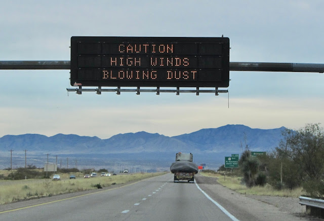
As usual, the temperature dropped and frozen precipitation increased as we gained elevation making our way south on the plateau. The highest point we reached on what is now signed US-89T (temporary?) was a little over 6,000 feet. By that time, the temperature was at 31° (down from 37° when we left Page), but precipitation had diminished to almost nothing and visibility had improved significantly.
Along that stretch, we were still in the Navajo Nation, but saw only a few isolated homes, no settlements along the entire section from just outside Page until we reached the tiny crossroads labeled The Gap, where the road rejoined US-89. Though we had seen deep snow cover along the roadside at higher elevations, by the time we were back on 89, the shoulders and nearby mesas were snow-free.
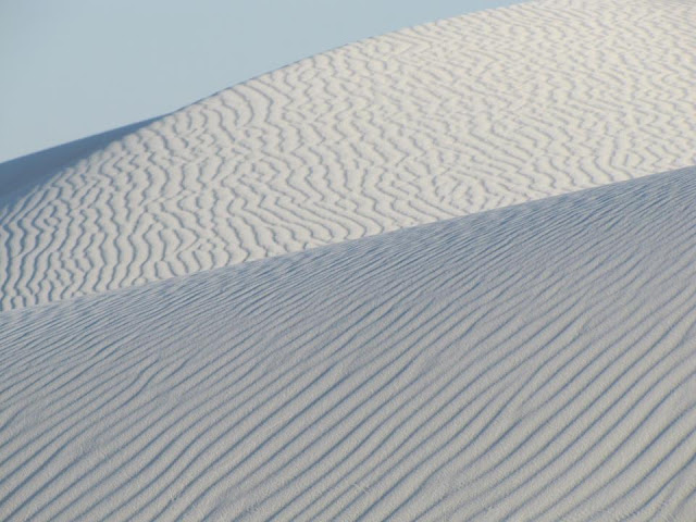
In Cameron, we stopped at the historic Cameron Trading Post to track down a letterbox before continuing south to a couple of National Park Service locations—Wupatki National Monument and Sunset Crater Volcano. At the ruins of the Wupatki Pueblo (pictured above), we saw a multi-level, high-rise structure which once had about 100 rooms. The local area provided materials ideal for the construction of freestanding masonry walls.
Sandstone slabs, limestone blocks and chuncks of basalt set with a clay-based mortar created sturdy buildings that remain at least partially intact after more than 700 years. This structure was built during the 1100s when Puebloan people came together in this area to erect a vast farming community. But then the nearby Sunset Volcano erupted, and by 1250 A.D., the ancient pueblos stood empty as the farmers moved on and established new homes elsewhere.
We experienced our high temp of the day (39°) at the visitor center for this monument. Within 15 minutes, we had climbed some 1,000 feet in elevation, and snow was falling. But there were letterboxes to be found, so we couldn't let any adverse meteorological conditions deter us.
Searching for the letterbox |
Continuing around the loop road which goes through both NPS sites, we came to Sunset Crater Volcano, which was largely hidden in snow and cloud cover today.
A valiant effort, but the sun did not break through. |
Tomorrow, we'll move south to Phoenix, where we should encounter some warmer temperatures, and visit the state capitol.
**The last time we drove thorough Flagstaff, in 1995, we got stuck on I-40 for several hours in a snowstorm waiting for the uprighting of two tractor trailers that had jackknifed and overturned.
space
Black volcanic soil near Sunset Crater Volcano |
Suspension bridge over Little Colorado River at Cameron |
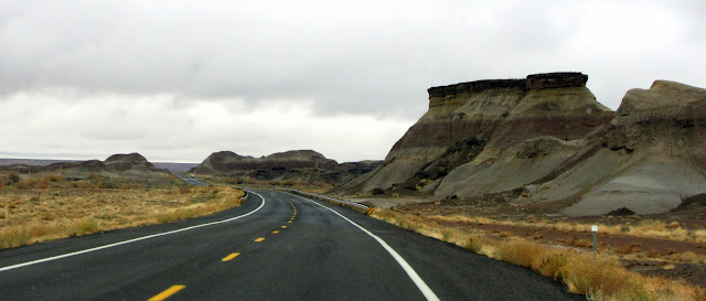
Some of the widely varying rock formations roadside along US-89 |
Snow falling near Sunset Volcano |
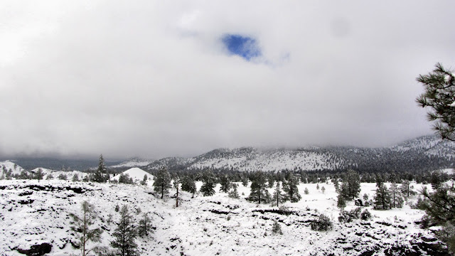
That bold spot of blue sky had no chance. |
ON THE ROAD AGAIN , Day 16: Page, AZ One of the signature experiences around the isolated town of Page (pop. 7,316) is visiting a slot ...
Playing the Slots
Thursday, November 21, 2013 Road Junkies 0 Comments
One of the signature experiences around the isolated town of Page (pop. 7,316) is visiting a slot canyon. Slots are formed in arid areas when flash floods propel water through soft rock, such as the Navajo sandstone south of Lake Powell, cutting a narrow canyon. Slot canyons are significantly deeper than they are wide, and in this area they are usually very photogenic with layers of red and orange sandstone formed in swirls and waves over many millions of years.
Though a slot canyon hike was on our list of things to do while we were in Page, our first sighting of one of the tour vehicles gave us pause. Travel out into the sandy desert—with temperatures in the 40s—jostling on the open back of a pickup truck on a bench? Not likely. The slot canyons began to lose their luster until, while searching for a letterbox in town, we came across a business called Slot Canyon Hummer Adventures. OK, that's what we're talking about. As it turned out, there was much more to like about this tour company than their closed vehicles equipped with seatbelts.
Around Page, all the slot canyons are on Navajo land. Most of the Navajo tour operators take hikers to Lower or Upper Antelope Canyons in groups of 20 or so on the back of 4WD trucks. Since all these tour operators pack hikers into the same canyons, nightmare stories are common of visitors being crowded in a slot canyon with upwards of 200 people pressed by tour guides to take their photos and keep moving.
The Hummer tour company operates tours in a different set of canyons, thanks to an exclusive agreement with a local Navajo landowner. Never do they take more than 10 visitors to the same canyon simultaneously. And since we were in the off-season, our tour consisted of just the two of us and our very knowledgeable and congenial guide Matt. Yes, we paid a bit more ($105 vs. $35), but the variation in the cost was disproportionate to the overwhelmingly better experience.
For the next two hours, Matt educated us on meteorology, geology, botany, zoology, and—much to our surprise—photography. A native of south Florida, Matt clearly loves the Arizona desert, where he has spent the last 15 years. He spent high school summers hiking and off-roading in the area and is thrilled to be doing the same as an occupation.
In his experiences leading canyon tours for professional photographers, Matt has picked up quite a store of knowledge about how to best capture the light and color that makes these slot canyons so striking. Guiding three or four tours seven days a week during the busy season, he has seen virtually every camera tourists typically carry and can quickly demonstrate to guests the best settings on their own cameras to help them take home photographic treasures from their canyon adventure. And, of course, he knows all the best spots and angles for photos in this canyon. To get a great photo of his guests, he will even "chimney climb" (scale the canyon walls by alternating between toe holds on opposite walls) to get to the right spot.
Once sated, we took off with our Matt map of the Page area. After we returned from our canyon hike, our passionate guide had eagerly shared his recommendations of the best local places to visit. Our first stop was the Hanging Garden trail near the Lake Powell Dam. A half-mile hike through striking red rock topography took us to an impossibly fertile garden hidden in an alcove under the mesa top, high above Lake Powell.
Hanging Garden |
As we finished our hike back to the car, rain began falling, foiling our plan to make the hike to the famous Horshoe Bend of the Colorado River. That may not matter. With the uncertainty of what the winter storm the Weather Channel is calling Boreas will do to our plans to head to Utah tomorrow, we may be in Page a little longer and have another opportunity to check out Horseshoe Bend.
Matt explained how flash floods form slot canyons. |
Trail to Hanging Garden |
Hanging Garden trail |
Along the trail to the hanging garden |