And Then It Was Done

Sunday, October 12, 2014 Road Junkies 0 Comments

A WANDER DOWN UNDER, Chapter 32: 
IN WHICH WE ALOHAED BRIEFLY
      
Days 37 - 41:  Auckland to Honolulu to Home

Thanks to the incredible soundproofing at the Novotel Hotel, we had a great night’s sleep, even though we were literally on the property of Auckland’s busy airport Wednesday evening. Our 11 am Air New Zealand flight to Honolulu afforded the opportunity for a relaxed morning. The flight departed on time, and in a muddle of confusion created by crossing the International Date Line, we arrived in Honolulu about 9 pm the previous night.  After picking up a rental car at the airport, we made a beeline for our hotel near Diamond Head, ready for rest after the exhausting 9-hour flight. 
 pace  
We had three purposes for our stop in Hawaii. Our primary motivation was to break up the trip. Flying from Auckland to Atlanta in a more direct fashion would require about 20 hours of flying time interrupted by 12 or more hours of layovers with no rest. No, thank you. In addition, we wanted to find a letterbox and plant a letterbox in Hawaii. We had done both in all the 48 contiguous states in 2012 but still had Alaska and Hawaii to go. 

Thirdly, we had a yen to visit the Hawaii state capitol building (pictured above) since checking out statehouses has also become a passion of ours. Two days seemed the perfect length of time for these modest goals.

On our first day, we were happy to get a late start before setting out to find a letterbox and plant one in Honolulu.  Those two tasks took us some time but we were well fortified by an incredible treat we found at the local McDonald's.  Stopping there for a coffee and Diet Coke, we noticed something different on their menu.  Rather than the apple pie featured at mainland Mickey D's, the Hawaii restaurant offered up a delicious alternative—banana pie.  And was it ever delicious!  Tasted so good you knew automatically it had to be bad for you.  At least we needn't worry about it becoming a habit since we had only one more day in Hawaii.
     
After we accomplished both our letterboxing objectives, we decided to visit the Pearl Harbor National Memorial.  When we arrived, however, it was so impossibly crowded that we decided to skip it for this trip.  The following day we went to check out the Hawaii state capitol, a much less crowded location.

At a cost of $25 million, the Hawaii statehouse was constructed of concrete after statehood was granted in the 1960s.  Unlike most capitol buildings in other states, its design is decidedly modern, reflecting the architecture of the period in which it was built.  
     

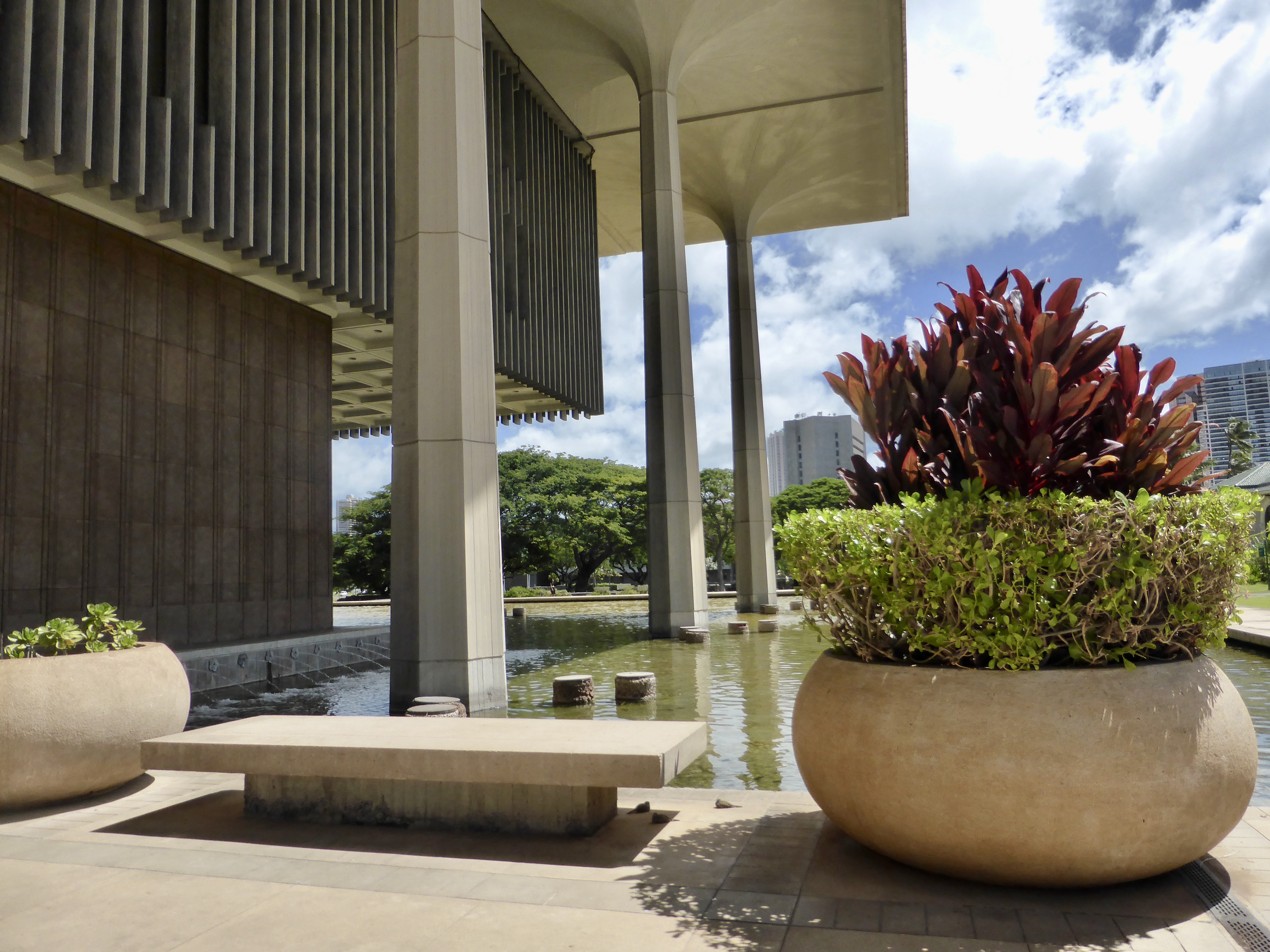
Like Honolulu's airport terminal, the Hawaii statehouse was designed with an open-air style.  Reflecting pools symbolize the seas which surround the islands.  On its perimeter, the capitol has eight pillars shaped like royal palms to represent the eight islands.  
     
Open air dome & courtyard
The building's open-air rotunda and dome represent a volcano with the building a symbol of an island.  Aquarius, the 36-by-36-foot mosaic on the courtyard’s floor, is made of 600,000 ceramic tiles that are no bigger than a fingernail. It’s a replica of a painting by Tadashi Sato, who was born and raised on Maui.  The design represents the changing colors of the Pacific Ocean that surrounds Hawaii.  
     space  
Senate Chamber
Both the legislative chambers are cone-shaped, also symbolizing the volcanoes which formed the islands millions of years ago.  The Senate's home is adorned in colors of the sea and sky and features a sculptural chandelier symbolizing the moon.  The fixture was created with 620 nautilus shells.  The 40-ft. tapestry on the wall behind the podium also features blue tones representing cloud patterns and double-hulled canoes on the Pacific Ocean.
     
House Chamber
The House Chamber is decorated with the warmer tones of brown, red, and orange to represent the earth, or island. The gold-plated brass chandelier represents the sun.  The tapestry displayed behind the speaker's podium represents palm trees growing out of the earth.  The work is also nearly 40 feet high and was made with 900,000 wool knots on a linen backing.
     
Koa wood in furniture and paneling
Throughout the capitol, the wood used for both furniture and paneling is an indigenous Hawaiian hardwood called koa wood, including a large ceremonial desk used by the governor for important signings and other events.

Running on fumes by the end of our tour, we limped back to the hotel for some rest.  Too tired to go out to eat, we were delighted to find a brochure for a food delivery service in our room.  We kicked back and waited for our California Pizza Kitchen meal to arrive and packed for our flight home tomorrow.

Again we deliberately chose flights that would break up the trip home and save us from another 9 to ten hour flight.  So after 5.5 hours, we stopped in Los Angeles, where we ate dinner and moved around a bit for a couple of hours before the final 4.5 hour flight to Atlanta.  When we arrived at Hartsfield Airport at 6 am, we were very happy to see the faithful Faisal, who picked us up and returned us back home.
Final Stats:
  • Started in Auckland, ended in Atlanta
  • Mileage - 9,073  (Trip total:  24,905)
THURSDAY, 9 OCTOBER, to SUNDAY, 12 OCTOBER, 2014

Yum to the 10th power!

The Beginning of the End

Wednesday, October 08, 2014 Road Junkies 0 Comments

A WANDER DOWN UNDER, Chapter 31: 
IN WHICH WE BID THE KIWIS FAREWELL
      
Days 35 & 36:  Auckland
   space   
Though Auckland offers all the cultural, dining and shopping amenities one would expect from New Zealand's largest city, it manages to retain a friendly and relaxed, small-town atmosphere.  Before diving into the city proper, we decided on Tuesday to explore its surroundings.  We set out on the scenic drive through the Waitakere Ranges, a chain of hills along the coast northwest of Auckland.  Formed by ancient volcanic activity, the ranges are covered in lush native forests and crisscrossed by hundreds of miles of walking trails.

Like many locals, we stopped in the seaside town of Piha, a favorite beach destination for Aucklanders, where even the neighborhood dogs are friendly.  While walking on the beach, Ken was approached by a canine beach bum, who pulled a stick out of the sand and tried to persuade Ken to toss it for him.  Long, tall waves offered up by the Tasman Sea invited surf school participants to try out their new skills.  We stretched our imaginations to comprehend how Lion Rock (pictured above) at the shore got its name.

At a scenic overlook, where we paused for lunch, we chatted with six young twenty-somethings on vacation from China.  When we expressed an interest in visiting their country, they were quick to warn us about China's severe problems with pollution, though one patriotic young man asserted that air quality there was improving.

After checking out some of the other beach towns, we returned to Auckland in late afternoon, stopping at Point Erin Park at the southern end of the Auckland Harbour Bridge.  We still had not planted a letterbox in New Zealand, and Auckland was our last opportunity.  From the park, we took advantage of the pedestrian lane and crossed the bridge over the SH-1 freeway to Westhaven Marina, searching for possible letterbox locations along the way.  Finding nothing but a great view of the city, we returned to our apartment, hoping for better luck on the following day.

By Wednesday morning, we had dreamed up the perfect spot for our letterbox, on a path near the SH-1 overpass, just across the street from Point Erin Park.  Like Victoria Park across the street from our apartment, Point Erin was active with numerous groups engaged in various forms of exercise, from yoga to rugby and cricket, basketball, skating and even juggling.  Aucklanders clearly like to stay fit.

Auckland Art Gallery
Our boxing business behind us, we set off for the stunning Auckland Art Gallery, home of New Zealand's largest art collection with more than 15,000 works ranging from classical to contemporary.  The gallery reopened in 2011, after a comprehensive renovation of the original 1887 structure and construction of a modern addition which blends smartly with the old. Graced with a lofty ceiling inlaid with native kauri timber, the extension provides a grand entranceway to the country's oldest art museum.

Tiny patrons of the arts at AAG
With both exhibits and activities designed to appeal to all types of people, the gallery was teeming with patrons on this Wednesday morning.  We were quite amused by a group of adorable preschoolers craning their necks to examine works in the Mackelvie Gallery.  On the museum's entrance floor, a 40-ft table held an interactive exhibit composed of three tons of white Lego bricks, which visitors were invited to use in creating their vision of a future city.
  space  
Creative AAG signage
Throughout the museum, signage, brochures, notecards and posters in the giftshop, and most every other written communication emphasized that this was a place for ART. Creators of these notices were quite clever in their choice of wording to allow incorporating the not so subliminal ART message. Even the menu at the Gallery Cafe, where we enjoyed a delicious lunch of charred broccolini with smashed avocado in a beautiful setting, was ARTful.

Adjacent to the gallery is Albert Park, occupying an area which once housed Albert Barracks, an early European military fortification.  Converted to a park in the 1880s, the space is home to some enormous specimen trees, including several Moreton Bay figs and an ombu tree.

Some of Albert Park's stately Moreton Bay fig trees
From the gallery, we headed southeast to Auckland Domain, the city's oldest public park and home to the Auckland War Memorial Museum, an imposing neo-classical landmark overlooking the park.  So much more than a repository for military artifacts, the museum boasts a wide-ranging collection of works featuring Maori culture, human history, and natural science.  Military exhibits commemorate New Zealand's involvement in two world wars and other more recent conflicts.  

Auckland War Memorial Museum
Unlike the Auckland Art Gallery, admission to the museum was not free.  After paying $9.00 to park, we paid the foreigner admission fee of $25 each.  (New Zealanders are admitted at no charge.)  Orientation from the helpful ticket agent informed us that military exhibits were on the upper floor, natural history (where you'll find hundreds of kids, she advised) was on the middle floor, and an extensive collection of artifacts from Maori and other Polynesian cultures was on the ground floor.  We spent a couple of hours checking out the fascinating exhibits.

Leaving the museum in late afternoon, we got a taste of Auckland's rush hour traffic, as we drove five miles out Broadway, through a very busy retail and commercial district, to the aiport.  We were checking in at an airport hotel in preparation for our early flight to Honolulu tomorrow morning, planning to return our rental car this evening and find transportation back to the hotel and catch the shuttle to the airport.  

Little did we know until we arrived that the hotel was literally across the street from the terminal.  Hertz was a hundred yards away, so we were able to accomplish all our goals, ready for a smooth exit in the morning.  After dinner at the hotel restaurant, we packed and weighed our bags, ready to catch our Air New Zealand flight to Hawaii tomorrow on our way home.

Daily Stats:
  • Started & ended in Auckland
  • Mileage -  111   (Trip to date: 15,832)
  • Weather - 41° to 56°, sunny to overcast
TUESDAY, 7 OCTOBER, & WEDNESDAY, 8 OCTOBER, 2014
   
Exquisite kauri timber ceiling at Auckland Art Gallery
Massive windows blur the line from interior to exterior at Auckland Art Gallery.
Maori pataka (storehouse) at AWMM
View from our hotel room
A Kiwi postie (mail carrier).  Most ride bicycles, rather than motorbikes as in Australia.

The Sky's the Limit

Monday, October 06, 2014 Road Junkies 0 Comments

A WANDER DOWN UNDER, Chapter 30: 
IN WHICH WE TRAVERSE HOBBITLAND
      
Day 34:  Rotorua to Auckland
    space  
Back on State Highway 5, we left Rotorua and its clouds of steam and pungent aroma around 9 a.m., aiming northwest for Auckland, New Zealand's most populous city with two million people.  That's almost a third of the national population, 1.4 times the entire South Island, and more than twice the size of Christchurch and Wellington combined.
     
Around 10, we stopped for relief and refreshments in the quaint village of Tirau (pop. 730).  At the crossroads of SH-1 and SH-5, the town has transformed itself from a rural service center to a tourist stopoff.  Recycled corrugated iron, embraced as a building and unique signage material, has given Tirau a signature look.
  space  
Tirau signage
In keeping with the town's singular style, the visitor center is completely covered in corrugated iron in the shape of a giant dog, as is the nearby Big Sheep Wool Gallery, a shop selling woolen items and other New Zealand products.
        space  
Fortunately these two seem to peacefully co-exist. 
North of Tirau, we headed west on Totman Road toward the renown Hobbiton movie set, which has become a major tourist draw in New Zealand.  After the initial movies were filmed, the sets that had been built on a local farm were dismantled and removed.  But Tolkien fans flocked to the site where the Shire had been created anyway.  After filming the later movies, producers allowed the Hobbiton set to remain.

Today hobbit hounds can take a two-hour guided tour of the set for the princely sum of $75 each.  By the time we arrived at the ticket office at the farm, the morning's intermittent showers had become a steady downpour, which the gusting wind flung into your face and down your collar.  Thankful we were not diehard Tolkien devotees, we easily made the choice to pass on the Hobbiton tour and press on toward Auckland.  In our drives around the country, we've seen so many mystical, magical landscapes, it's hard to believe we missed more than a few hobbit houses.

Middle Earth wherever you look
We returned to SH-27 and drove north, the steady rain a constant companion.  After turning west on SH-2 we began to feel a coastal influence on the weather as the hovering slate clouds dumped out a deluge, settled back to drizzle and then cleared, as winds shuttled the clouds inland.
   
Arriving in Auckland, we checked in and unloaded our bags in our apartment at Quest on Belmont before heading over to the Sky Tower, a 1,076-ft observation and communication tower that dominates the Auckland skyline.  A bargain price of $17 bought us tickets to the glass-walled observation decks at 610 ft and 720 ft.
   
Riding up on the elevator, we chatted with John, a 20-something Brit wearing a bright blue and yellow jumpsuit.  And that is literally what it was—a jump suit.  From John, we learned about the Sky Jump activity offered at the tower.  Between the observation decks is a jump platform at 630 feet.  Harnessed in and guided by steel cables to prevent wind gusts from slamming them into the tower, brave souls step off tower firma into thin air, aiming at a target 53 stories below.
   
For the entertainment of those who prefer to experience such thrills vicariously, an LED message board on the main observation deck two floors below alerts visitors four minutes prior to a jump, allowing spectators to get into viewing position.  Benches are actually provided.  So we watched John, who had also bungee jumped off the Auckland Harbor Bridge, take the tower tumble.
   
John takes a dive
Quite a bit of entertainment for the price, and the views of the city were terrific also.  After watching several jumps and failing to persuade ourselves that we wanted to try it, we headed out to dinner and back to our hotel for the evening.  We have two more full days to explore Auckland before heading off to Honolulu and home on Thursday.
Daily Stats
  • Started in Rotorua, ended in Auckland
  • Mileage -  167   (Trip total: 15,721)
  • Weather - 45° to 57°, damp and drizzly to partly cloudy
  • Sky jumpers we watched - 4
MONDAY, 6 OCTOBER, 2014
     
Scenic drive or what?
Playing with the camera
View of Auckland from the Sky Tower
The small red square at the bottom center has the jump target painted on it.

Full Steam Ahead

Sunday, October 05, 2014 Road Junkies 0 Comments

A WANDER DOWN UNDER, Chapter 29: 
IN WHICH WE ENCOUNTER A REAL LIFE SOAP OPERA
      
Day 33:  Rotorua
    space  
After yesterday's disappointing dry hole geothermal experience, we dived into some serious research on Trip Advisor last night.  As the grandfather of New Zealand's tourist industry, Rotorua has no shortage of attractions eager to draw their share of area visitors' spending money.  Based on our study of reviews, we winnowed the profusion of possible sites to two.  Perusal of their web sites resulted in elimination of one attraction, leaving us with only the Wai-O-Tapu Thermal Wonderland.

In our research, we had learned that Wai-O-Tapu boasted the Lady Knox geyser, which erupted daily at 10:15 a.m.  Since Daylight Saving Time started last week, we speculated that the eruption would probably occur around 11:15 today.

Arriving a little after 9 a.m., we forked over $65 for two tickets to wonderland.  At the ticket counter, we asked if the eruption was predicted for 11:15 today.  No, 10:15, like always, we were told, and that set us wondering.  When we inquired whether the geyser had some mechanical assistance, the ticket agent informed us that chemical stimulation was used, rather than mechanical. 
    

After perusing the Wai-O-Tapu map and brochure, we calculated that we had just enough time to explore the one-mile circuit of the "top features" and make it to the geyser eruption site by 10:15.  Off we went on the paved trail, soon encountering the first of a number of craters—Devil's Home, a crater collapsed by acidic action underground (pictured on previous page).  Not a place you'd want to stumble into, whether the devil was home or not.

On we went around the circuit, passing a variety of signed features, certainly with more geothermal activity than we saw yesterday, but still mostly steam.  At Artist's Palette, we did see a bit more color than at the landmark of the same name we saw yesterday south of Rotorua.

Artist's Palette
The star of the Wai-O-Tapu walking circuit is the Champagne Pool, the largest geothermal spring in the area at 200 feet wide and about as deep.  Formed by a hydrothermal eruption, the pool contains a variety of minerals which leave colorful deposits along its surrounding ledges.
    
Champagne Pool
Keeping our eye on the time lest we miss the 10:15 eruption, we zipped past most of the craters until we reached the Devil's Bath, a large crater with a striking chartreuse pool created by the reaction of excess water from the Champagne Pool, with its unique minerals, mixing with the sulphur and ferrous salts in the crater.
    
Devil's Bath
Just past this unholy pool, we reached the end of the circuit and hopped in our car to drive to the amphitheater where we would see Lady Knox erupt—on schedule, no less.  When we arrived, a crowd was already gathered, all but filling the 300 or so seats.  Most had cameras in hand, poised for the anticipated geothermal action.
    
Ready for action
Still pondering how the chemical stimulant had been set up for a precise 10:15 eruption, we enjoyed the people watching and jostling for camera position as we all awaited the gusher display.  At the appointed hour, a ranger stepped over the railing and took his place next to the geyser—not wearing an asbestos suit or any other type of protective gear.  When he began to speak, excitement mounted as we all wondered whether he would be able to escape the danger zone before the eruption began.

Look out, Mr. Ranger!  It's 10:13!!
As we nervously listened, the ranger related the history of Lady Knox Geyser.  In the early 1900s, an experiment was conducted which brought some of the better behaved inmates from area prisons to work on the land.  When they were washing their clothes in a hot spring in this clearing, they discovered that the addition of soap to the spring generated an eruption.

Of course, this turned out to be a rare source of entertainment for the isolated prisoners, so they built up rocks around the opening of the spring to enhance the eruption.  And then we realized why the ranger had a package in his hand—and why he was not concerned about stepping next to the geyser at its anticipated eruption time.  Since 1931, a tourist attraction has operated here, with daily deposits of a substance which reacts with the spring the way the laundry soap did.  Silica from those eruptions has built up on the rocks, creating a cone-shaped structure.
   
Lady Knox erupts
Despite the artificiality of the event, when the ranger dropped his package into the cone, the crowd waited with bated breath and erupted in oohs and ahhs when water began to spurt from the spring, The cameras were clicking, the videos were rolling, and the tourists were happy.

Later in the day, we walked a bit around Lake Rotorua, where the steaming hot springs were on view with no admission fee.  With its iconic place on the New Zealand travel map, we chose not to skip Rotorua.  But the duck rides, the innumerable souvenir shops, and the efforts to promote itself as "RotoVegas"—not to mention the ubiquitous sulphur odor—should have informed us that it might not be not our favorite kind of town.

Tomorrow we'll hit the road again, driving northwest to Auckland, New Zealand's largest city and our final stop in this beautiful country.

Daily Stats
  • Started in Rotorua, ended in puzzlement
  • Mileage -  45   (Trip total: 15,554)
  • Natural geyser eruptions - 0
  • Artificially induced eruptions - 1
  • Happy tourists - 12,839
SUNDAY, 5 OCTOBER, 2014
  
Steamy Wai-O-Tapu 
Rotorua Museum of Art and History, located in the old bath house building

Water in All Its Forms

Saturday, October 04, 2014 Road Junkies 0 Comments

A WANDER DOWN UNDER, Chapter 28: 
IN WHICH THINGS GET WATERED DOWN
      
Day 32:  Napier to Rotorua
    space  
Saturday morning blew in with sparkling blue skies as we watched the sun rise over Hawkes Bay from the comfort of our hotel room.  For one last view of Napier before leaving town, we drove up to Bluff Hill Domain, a park overlooking the port and the city.  Once the site of a defensive World War II gun battery, the bluff has been transformed into a botanical delight with blossoms in shades of yellow, red. blue, orange, purple and pink (pictured above).  Every plant seemed to be in bloom on this sunny spring morning.

Today's forecast called for 25 to 35 mph winds again, and at the top of the bluff we could feel the full force as we gazed down at the port activity.  Significant amounts of sheep's wool, timber, and wood pulp pass through Napier each year bound for export markets.  Much of the region's apple and grape crops are also shipped from this port, as well as the products of Hawkes Bay wineries.  After a brief stop to admire the boats in the town marina, we finally turned our backs on the bay, headed inland on State Highway 5, the Thermal Explorer Highway.

Bluff Hill offered an excellent bird's eye view of this busy port.
Just ten miles north of Napier, we spotted an LED highway alert sign near Eskdale, warning of winter driving conditions along our route.  The pump jockey at the Mobil station where we stopped for fuel confirmed that snow had fallen in the mountains last night.  We were encouraged by his confident assurances that between the traffic and the wind, the road should be cleared by the time we reached the snowfall area.  Meeting a snowplow a few miles up the road heartened us further.

Kaingaroa Forest
Along SH-5, we drove through mile after mile of the Kaingaroa Forest, the largest forest on the north island. After much of New Zealand's native forests were harvested by early settlers for building construction, the Monterey pine was introduced as a timber crop in the 1850s.  A fortuitous choice, the Monterey fared better in New Zealand than in its native California, maturing in this temperate environment in less than 30 years,  Nine-tenths of New Zealand's massive plantation forests today are planted in Montereys, feeding the country's exports of logs, timber and paper products.

A section of the forest after harvest
Encompassing an area the size of Rhode Island, the Kaingaroa Forest was established as a plantation forest in the 1920s, a state asset owned by the NZ government. In 2009, the land was restored to its traditional Maori owners.  The forest is planted and harvested by private companies which rent the land.  As in other parts of the country, forests in all stages of growth and harvest were visible along the roadway.  Due to their endangered status, logging of native forests is now prohibited unless the land owner can prove it sustainable.

Waipunga Falls
North of the tiny crossroads called Tawarewa (emergency petrol the only service available), we pulled into a scenic lookout for a break.  When we got out of the car to stretch our legs, we were treated to a breathtaking view of Waipunga Falls, a tiered waterfall created as the river of the same name plunges 130 feet down into the valley below.  What a fanastic place to site a rest area!

As we passed by a handful of buildings identified on the map as the hamlet of Rangitaiki, the intermittent rain briefly changed over to sleet.  A bit later we watched a heavy spate of sleet bouncing off the pavement as we were eating lunch at The Vine in the town of Taupo.  Although the service was abysmally inefficient and confused, we didn't mind too much as we weren't eager to head back out in the icy shower.  Moreover, the food was quite good and we were engaged in a lively conversation with an Australian couple, Jenny and William, at the next table.  They had driven into town from a fishing lodge at the southern end of Lake Taupo, a spot they have visited annually for 20 years, stalking steelhead trout in the lake and area rivers.

Looking upstream against the powerful current of the falls
When we finally left The Vine, we hooked up with SH-1 and drove north to Huka Falls, a powerful 53,000 gallon/second cascade created when the 350-ft. wide Waikato River bulldozes its way into a canyon 50 feet across to reach Lake Taupo.  From this impressive falls, we visited the nearby Mighty River Geothermal Station.

Renewable resource independent of weather
Built at a cost of $415 million and opened in 2013, this plant can provide electricity for 80,000 households, making it New Zealand's largest geothermal power station.  Steam is provided by wells up to 10,000 feet deep with temperaures approaching 600 degrees.

A bit of magical scenery on Tutukau Road
North of the power plant, we shifted over to SH-5, enchanted by the lumpy, grassy hills and valleys.  Surely Tolkein had this area in mind when he envisioned Middle Earth.  Many shelterbelts have been planted in this windy landscape.

Near 3 p.m. we took a detour west onto Tutukau Road to check out the Orakei Korako geyser field.  At $28 each, the admission was a bit steep but the reviews we checked on the fly as we drove north indicated this was an opportunity to see "Rotorua without the tourists."

Soda Fountain geyser
Small wonder there were no tourists; there were no active geysers, just some steam puffing out and a tiny bit of half-hearted bubbling.  Signage warns visitors that most of the thermal springs on site could erupt at any moment.  Yet the boardwalk "erected for your safety" passes within a few feet of these dangerous and capricious gushers.  

More subtle messages told another story.  The rocky surface around most of the geysers in this field was bone dry.  It was difficult to choose which rationalization we should accept for the inactivity—the erratic eruption evasion offered by the visitor center staff or the alibi given us by boat operator who ferried us across the river to the geyser field:  "Well, the weather is just too cold for the geysers to be active" (the kind of statement that makes you start rubbing your forehead to wipe off "STUPID," which you assume must be written there).

Arriving in Rotorua around 5 p.m., we checked into our Quest apartment hotel, prepared dinner, and made some hot plans for seeing the local geothermal activity tomorrow.

Road Noise

As we've often stated, the left-lane driving in New Zealand and Australia requires constant vigilance from us right-laners, particularly since all the roads we're driving on are unfamiliar to us.  One form of signage that adds to the confusion is the yield sign painted on the road at many intersections.

Yield sign or one-way arrow?
Meant to signify that the driver approaching the intersection should yield to the oncoming traffic on the cross street, to someone accustomed to right-lane driving about to turn onto the road, it can appear to be an arrow pointing in the direction of the traffic flow, the way this type of signage is typically used in the U.S.  Following that instinct, of course, would put you on the wrong side of the road.
Daily Stats
  • Started in Napier, ended in Rotorua
  • Mileage -  175 (Trip total:  15,509)
  • Weather - 45° to 57°, sunny, windy, rain, sleet
  • Active geysers - 0
  • Excuses for why geysers were inactive - 4
SATURDAY, 4 OCTOBER, 2014
    
The erroneously named 'Artist's Palette' purported to exhibit all the colors of the rainbow
Ruatapu Cave, alleged to be one of the world's two caves in a geothermal field
A bit of geothermal humor