Saturday, June 27, 2015 Road Junkies 0 Comments

MAINE COURSE, Chapter 6.
IN WHICH WE LOSE OUR COOL
  space. 
Days 7-10.  Ellsworth, ME to Home

Wednesday, 24 June—Ellsworth to Portland

The sun shone brilliantly over a cloudless blue sky Wednesday morning as we finally left the Ellsworth/Acadia area at 7 a.m., driving west toward Augusta for a visit to the state capitol.  Just before 8, we recrossed the spectacular Penobscot Narrows Bridge and shortly stopped at Mt. Prospect Cemetery in Stockton Springs for our first letterbox of the day.
   space 
Penobscot Narrows Bridge
Continuing our letterboxing adventures into Searsport (pop. 2,615), we started at Bowditch Cemetery, the oldest in town.  We were on the hunt for a series of 14 letterboxes planted by local boxer Jiffy.  Next up was Elmwood Cemetery for two boxes, then an interruption for a trio of boxes not in the series.  Then we moved on to Village Cemetery, where we snagged two more but skipped two that were well guarded by poison ivy.
   space 
Moving on to Mount Hope Cemetery, we located three more.  At the time we arrived at the small Gordon Cemetery, the final graveyard, for the last three boxes in the series, preparations were underway for an interment.  With a single entrance/exit and no designated space for parking, there was a good chance we would be trapped until the end of the service if we stayed to find the boxes.  So we left and drove back to US-1. 
   space 
Another Searsport captain lost to the sea
In every Searsport cemetery we visited, we noticed an unusual number of sea captains, as noted by the inscription "Capt." or "Died at Sea."  As we later learned, Searsport produced more shipmasters than any town of its size in the world, and was once home to one-tenth of the deepwater ship’s captains in the American Merchant Marine.
   space 
Connected Farm
On our way out of Searsport, we passed a connected farm along the highway that was for sale.  Featuring a big house, a little house, a back house and a barn, this type of architecture dominated rural Maine dwellings before 1900, and we had seen quite a few on our travels in the state.  With all the buildings linked, a farmer could go from house to shed to barn and complete all his daily chores without setting foot outside, a big advantage on a stormy day or in extreme cold.
   space 
Driving south on US-1, we tracked near the coast until we reached Belfast (pop. 6,660), a seaport popular with tourists, where we paused to check out the town and have lunch.  Our first choice from Yelp wasn't open today, which turned out to our advantage when we ended up at Darby's Restaurant and Pub.  Perfectly situated in an 1865 building that originated as a pub, Darby's boasts the same walls, tin ceiling and antique bar that were installed the year the Civil War ended.  I ordered their zucchini sliders—seasoned grilled zucchini slices with fresh mozzarella, bean sprouts, tomato and fresh basil mayo.  Delicious!  Ken had blackened salmon salad with beets and spinach—also excellent.
   space 
From Belfast, we turned inland on ME-3 toward Augusta.  The temperature seemed to climb as we moved inland away from the coastal breezes.  After visiting the state capitol, we drove on to the Portland area and checked into a Homewood Suites for the next few days, happy to have a little extra elbow room.
   space 
Thursday, 25 June—Portland
   space 
When we left the hotel around 9 a.m. Thursday morning, the temperature was already at 72°, a preview of what is to come as we make our way back south.  But the sun was shining and the letterboxes waiting, so we set out down US-1 after stopping by the local Michael's to re-supply our ink.
   space 
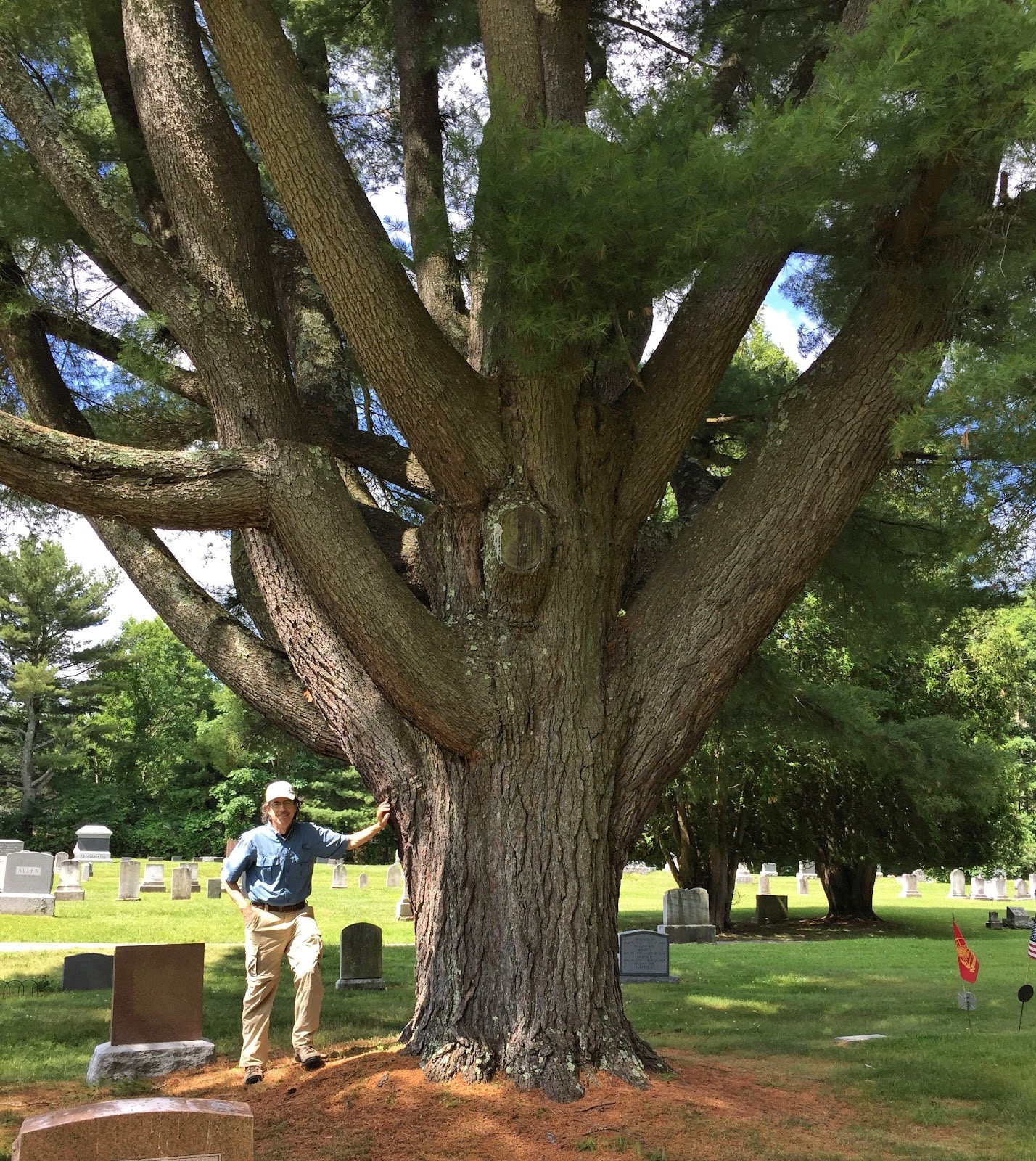
Massive pines like this one were in several cemeteries we visited.
We found some boxes in the Scarborough area in the morning—around the Eastern Trail and in some local cemeteries.  Local boxers are inclined to plant series—six to ten or even 20 boxes.  And the Portland area seems to be a boxing hotbed.  We found 14 letterboxes in the morning before stopping for what turned out to be a dismal lunch at Taco Trio in South Portland (who is rating them so high on Yelp?).
   space 
The afternoon turned in a better direction.  We started with a Tour the Fort series of six letterboxes around Fort Preble in South Portland—good carves, great background information, and well hidden.  Nearby was the campus of Southern Maine Community College, where Jiffy had stashed a series of 17 boxes related to the school's courses of study.  Finally, a series of five on a coastal trail in the area portrayed the options in the selection of a wedding dress.
   space 
Remains of Fort Preble
By the time we found the last box, we had amassed a total of 35 finds for the day while walking almost seven miles.  Glad that Homewood was offering its complimentary weeknight light meal, we dragged ourselves back to the hotel, ate dinner, and made plans for Friday, our last full day of the trip.
   space 
Friday, 26 June—Portland
   space 
In another episode to prove that no good deed goes unpunished, I managed to pull a crown off one of my molars while flossing my teeth Thursday night.  First I booked a restoration appointment with my dentist back in Georgia for Tuesday morning.  Then the interim plan for dealing with the issue until Tuesday was in play.
   space 
Plan A.  Go to CVS for some temporary dental cement to re-seat the crown.  
An hour after I started working on it, the crown was still in my hand and I had a new appreciation for the delicacy and precision of dentistry.  No matter how little of the product I inserted in the crown, it was too much and the crown would bang against my lower teeth long before the others made contact.
   space 
Plan B:  Find a local dentist to re-seat the crown.
Seventeen phone calls later, I figured this was not going to happen.  Most offices were closed or the dentist was off on Friday.  Others were booked solid.  
   space 
Plan C:  Re-seat the crown with Vaseline.
Yes, you read that rightVaseline.  After my abject failure with plans A and B, I called my dentist's office back for advice.  Should I just leave it out for three days?  The dental assistant I spoke with suggested cleaning and drying the crown well, filling it with Vaseline and putting it back in place.  Skeptically, I followed her directions precisely.  It worked!  (She also gave me a plan D in case I needed it...Fixodent denture adhesive.)
   space 
Finally with the crown back in its home, we left the hotel a little after noon and drove to Fort Williams Park.  Situated in Cape Elizabeth, the park is a popular tourist attraction, primarily because of Portland Head Light standing on its grounds.  Often cited as the most photographed lighthouse in the world, Portland Head Light was commissioned in the late 1700s by George Washington and is still operational today.
   space 
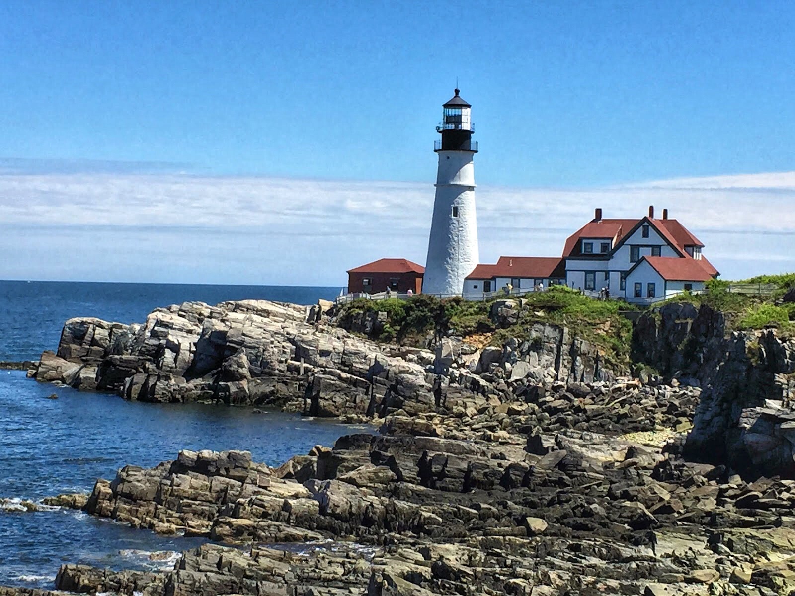
And the Most Photogenic Lighthouse award goes to... Portland Head Light.
We found three letterboxes along the hiking trails in the park and stopped to chat with Eric, a local resident who was tossing a tennis ball for his terrier Charlie to retrieve.  Later we followed his recommendation to drive to Higgins Beach and Prouts Neck for some scenic views, finding one more letterbox along the way.
   space 
With a 5:45 a.m. flight the next morning, we bagged the day early and returned to the hotel to unload the car.  Not wanting to deal with leaving enough time to return the rental car before that early flight, we drove it to the airport and made arrangements for Francisco, the driver of the hotel shuttle, to pick us up and return us to the Homewood.  A native of Angola, Francisco has been in the U.S. just three years.  He arrived speaking almost no English, just French and Portuguese.  With experience as a taxi driver in Angola, he was able to obtain work fairly readily in Portland.  But he said he finds the American accent quite difficult to understand since what little English he did know was learned from speakers of British English.
   space 
Located on the other side of the parking lot from the Homewood, Sebago's brewpub was an obvious choice for an early dinner since we no longer had wheels.  While we were there, we heard from cousin Pam that a couple of osprey chicks on Hog Island, Maine, had been snatched by an eagle.  We have been following this nest by webcam for a couple of years and hoped to visit the site while here but it didn't work out.  Sad about the loss but knowing that it was just nature taking its course, we returned to our room, packed up and set our alarms for 3 a.m.
   space 
Saturday, 27 June—Portland to Home
   space 
Though our flight was booked for 5:45, it was on United, so we didn't expect to leave Portland until eight or later.  They surprised us.  The flight left a few minutes early and landed at Dulles in Washington, D.C. 14 minutes before the scheduled arrival time.  Then to really keep us confused, the flight to Atlanta departed on time and also touched down a few minutes early.  Just when we thought we had United figured out, they try to lull us into a false sense of security.
   space 
The moment we stepped out the terminal door for our ride home, we were assailed by the heat and humidity.  Not that we weren't expecting it, but it still provided a rude reminder that our Maine course was over.  And this felt more like desert than dessert.
   space   space 
WEDNESDAY, 24 JUNE, 2015 - SATURDAY, 27 JUNE 2015
   space 
Trip Stats
  • Miles driven:  992
  • Air miles:  2,076 
  • Weather:  46° to 78°, sunny to rainy
  • Letterboxes found:  69
  • Lighthouses:  12
  • Bumpy miles of Maine roads:  988
  • National parks:  1
  • International parks:  1
  • Scenic views:  236
  • Sailboats:  6,130
  • Rocky shorelines: 875 
In a park near Penobscot Narrows, a sample section of the bridge shelters a picnic table.
Spring Point Ledge lighthouse
Another view of the Portland Head Light
And another
Daisies decorate the Cliff Walk at Fort Williams Park.

A Drive on Maine Streets 


Wednesday, June 24, 2015 Road Junkies 0 Comments


AUGUSTA, Maine—Upon entering the small city of Augusta (pop. 19,136), we had no difficulty locating the Maine State House.  From its position on a hill overlooking the Kennebec River, the domed capitol is quite visible from the Maine Turnpike as you enter the city.

After Maine broke away from Massachusetts to become the 23rd state in 1820, a bit of jockeying ensued over the location of the state capital.  Portland, still by far the largest and primary city of the state, was a popular choice, but its temporary status as capital was vacated due to its extreme southeastern location.  Augusta—farther north and inland—was officially proclaimed the state capital by Governor Enoch Lincoln in 1827.

Original 1832 Maine State House (image from Wikipedia)
Charles Bulfinch, a well-known American-born architect who designed the Massachusetts Statehouse and was doing some work on the national capitol, was hired to design the government building for Maine.  Drawing on his Massachusetts design, Bulfinch aimed for a simpler Greek Revival style which could be fashioned from local Maine granite.
      space. 
Current Maine statehouse
To serve the growing needs of a burgeoning government, the state scrapped all of the 1832 capitol building except the front portico and the wall behind it and doubled the size of the state house in a 1909-10 project.  Bulfinch's center cupola was replaced with a copper-clad dome.  Over time, the copper oxidized to a dull green.  In 2014, the original copper sheathing on the dome, which had become leaky over time, was replaced.  Today it is a flat brown and is expected to remain that color for another 30 or so years before oxidation restores the green patina.

State House dome before and after copper sheathing replaced
Visitor parking for the capitol was free and conveniently located across the street.  Security screening was competent and standard—walk-through metal detector and bag x-ray.  Near the exit to the security station was an information desk where a congenial state employee ensured that we picked up copies of the myriad and superfluous brochures about the state house.  Arriving at 1:45, we were too late for a guided tour, so armed with plenty of (sometimes conflicting) information, we were on our own.

Hall of Flags
In the center of the second floor, where we were told to begin our tour, we found the Hall of Flags, located under the dome but with a ceiling that blocked the view of the inner dome.  Arrayed around the room were massive display cases exhibiting replicas of battle flags used by Maine military regiments in various conflicts from the Civil War to Korea.  In the center of the hall is a bust of Percival Proctor, governor from 1921 to 1925.  Over a 30-year period, Baxter used his immense personal wealth to amass more than 200,000 acres of wilderness land in north central Maine, which he donated to the state, becoming Baxter State Park.

Portraits of prominent Mainers line the halls
As we found throughout the building, light fixtures in the Hall of Flags were basic, ceilings unadorned.  Only plain molding and trim decorate the walls, along with a collection of more than 140 portraits—governors, supreme court justices, state legislators and Congressional representatives, military heroes—a veritable conglomeration of prominent Mainers.  Placement of the portraits seemed to be random with a 20th century jurist next to a Civil War general.

Rotunda
In one of the numerous pamphlets we were shuffling on our self-guided tour, we found the state's perspective on the lack of opulence in its capitol building:  "Designed with restraint, the rotunda walls are relieved only by the simple lines of paired Doric pilasters and denticulated cornices."  As we were to learn, the Maine State House is deliberately plain and simple, a reflection of the Puritan ethic and frugality of its people.

Inner dome
Upon reaching the third floor, we had our first look at the admittedly prosaic rotunda and the inner dome above it.  Apparently the restraint was extended to the dome as well.  Its most prominent feature was a bulky black iron staircase that wound around the interior.
Chamber of the House of Representatives
Despite the lack of ornamentation, one feature the re-design architect, G. Henri Desmond, did not scrimp on was natural light.  It is the most arresting feature of both the House and Senate chambers, which also include considerably more molding and trim than any other parts of the building and even a coffered ceiling.

Capitol Park
Stretching between the State House and the river is a lush green landscape known as Capitol Park.  Over the years, the park has functioned as parade grounds, camp site, and even leased farmland.  Today it offers walking trails lined with oaks, beeches and pines and is home to Governor Enoch Lincoln's tomb and several memorials.

WEDNESDAY, 24 JUNE 2105
  space. 
  space. 
  space. 
  space. 
Maine State House Stats
  • Construction period (original):  1829-1832
  • Construction period (re-do):  1909-1910
  • Original cost:  $138,991 ($59,000 over budget)
  • Re-do cost:  $350,000
  • Remnants of Bulfinch design:  front facade
  • Building height (to tip of dome):  185 ft.
  • Dome topper:  "Lady Wisdom," 15-ft. gold-leafed copper statue
  • Dome surface:  copper
  • Exterior material:  Maine granite
  • Site size:  34 acres
  • Portraits hanging in statehouse:  141


Hall of Flags display
Flag of the 10th Regiment Maine Infantry, Civil War (lists battles in which they fought)
Senate Chamber


Tuesday, June 23, 2015 Road Junkies 0 Comments

MAINE COURSE, Chapter 5.
IN WHICH WE LEARN THAT FISH CAN CLIMB
  space. 
Day 6.  Acadia National Park

Cue Eliza Doolittle and Henry Higgins:
♪ The rain in Maine is giving us a pain. ♪
♪ The rain in Maine is driving us insane. ♪
♪ Here comes rain. ♪
♪ Rain again. ♪   
  space. 
♪ Our pleas for sun in Maine have been in vain. ♪
♪ The rain in Maine will send us to a plane. ♪
♪ We've got rain. ♪
♪ Rain can't drain. ♪
♪ The rain in Maine, it has become our bane. ♪
   
Admittedly, that is a bit of an exaggeration.  We have had plenty of sunshine since we arrived in the Pine Tree State on Thursday.  But somehow our planning to visit Acadia National Park triggers rain on the day we want to visit,  Today was no exception.  When we awoke just before 6:30 and saw that another massive rain system would move into the area by 10:30, we scurried to get dressed and get to the park, hoping to make a few stops before the precipitation began.
   space 
Sand beach, Acadia National Park
Upon entering the park around 8 a.m., we started off on the loop road and shortly arrived at Sand Beach, one of the few cold-water shell-based sand beaches in the world, according to the interpretive sign.  Unlike Gulf coast beaches where the sugar white beach sand has a heavy quartz content, this sand's primary ingredient is broken shells.  Though the sand appears to have a uniformly buff color, a closer examination reveals a complex mix of organisms and colors.
   space 
A handful of "sand"
Next stop along the loop was Thunder Hole, a rock formation whose small cavern stirs up the right combination of wave action and air pressure to force sea spray high into the air.  Most active near high tide or during storms, the blowhole was pretty quiet when we were there.  But some flowers nearby offered a pleasing contrast to the stony shoreline.
   space 
Flowers in bloom near Thunder Hole
Just a short distance farther on the loop road brought us to Otter Cliffs.  Rising more than 100 feet above sea level, the pink granite cliffs jut dramatically into the ocean and take a constant pounding from the crashing waves.  Adjacent to the loop road, Ocean Path at the top of the cliffs affords beautiful views of the dramatic scenery.

Otter Cliffs
By the time we hiked the Ocean Path a ways and returned to the car, the plump gray clouds were drooping lower as we stopped briefly at Jordan Pond.  With a drizzly wind blowing, we decided against a hike around the lake and moved on to Cadillac Mountain.  As we expected, the fog had enshrouded the mountain and the scenic lookouts offered up little to see but mist, though we did find a letterbox on the way back down.

Still too early for lunch, we decided to look for a few letterboxes hidden at Brookside Cemetery in tiny Somesville, the earliest village settled on Mt. Desert Island.  The cemetery was exactly what the name implies, a lushly green setting, generously shaded by stately trees, with a crystal clear brook cascading by its southern boundary.

Brookside Cemetery
As often happens, the clues for one of the letterboxes told an interesting story.  This one was about the alewife, a type of herring that migrates from the Atlantic into the freshwater Somes Pond near the cemetery to spawn.  The letterbox was hidden near a fish ladder installed to help the alewives transition from the swiftly moving brook into the pond.

Fish ladder
Light rain was falling most of the time we were in the cemetery.  Looking for letterboxes during a shower, we don't mind; hiking on granite trails, we'll wait for better weather.  With a steady downpour by the time we returned to Bar Harbor, we stopped for lunch at Side Street Cafe again.  Despite the fact that the restaurant was extremely busy, the food and service were both quite good.

Rain drove us back to the hotel this afternoon, where we did a little planning, hit the laundry room and relaxed.  After three days of soggy Acadia, tomorrow we're moving on to Augusta to check out the Maine State Capitol.
  space  
TUESDAY, 23 JUNE 2015
     
Ocean Path at Otter Cliffs
Brookside Cemetery had some gorgeously detailed cast iron monuments.

Monday, June 22, 2015 Road Junkies 0 Comments

MAINE COURSE, Chapter 4.
IN WHICH WE GO INTERNATIONAL
  space. 
Days 4-5.  Bangor, ME to Ellsworth, ME

After finally getting to sleep after the concert was over in BANGor Saturday night, we awoke to a steady rain on Sunday, wishing the rain had begun about 12 hours sooner. The forecast called for rain all morning, followed by an afternoon of rain before a rainy evening set in. We took that as a hint and decided to spend the day working on some projects that needed our attention. Thanks to laptop computers, your projects follow wherever you go in today’s world.

By noon, it was time to check out of the Courtyard rain shelter in Bangor and drive the 30 miles back to Ellsworth, where we would spend the night. Our plans to spend Sunday at Acadia National Park had been scrapped by the weather, so we spent some time in the afternoon outlining what we want to do for the remaining days of this trip before we go home on Saturday.

According to our revised agenda, we got up early Monday morning and left Ellsworth about 7:30, driving northeast on US-1 toward the Canadian border. Our destination was the Roosevelt Campobello International Park on Campobello Island, off the coast of Maine in the Bay of Fundy. Part of the Canadian province of New Brunswick, the island is about nine miles long and three miles wide.
   spac
FDR Bridge from Lubec, Maine, to Campobello Island, New Brunswick
Originally settled by Native peoples, the island passed through French hands and into British.  In 1767, Captain William Owen, a Welshman who lost an arm while fighting for the Royal Navy in India, traveled to Halifax with his friend and fellow officer William Campbell.  Lord Campbell had just been appointed governor of the British colony of Nova Scotia, and was persuaded by Owen to award him one of three islands in the Bay of Fundy as a royal land grant. As an homage to his benefactor, Captain Owen threw in a couple of o’s and named the island Campobello, aware from his classical education that in Italian, campo bello means beautiful field.

By the 1850s, the island began attracting visitors because of its natural beauty, mild summer climate, and proximity to large American cities of the Northeast.  As its popularity grew, a group of Boston and New York businessmen bought most of the island from the Owen descendants with the intention of developing it as a resort for wealthy Americans and Canadians. They built three large hotels on the southern end of the island and subdivided the area around them into seaside building lots.

Their timing was impeccable.  It was the height of the Gilded Age, when the very rich enjoyed an abundance of leisure time and vacations lasted all summer.  James Roosevelt, his wife Sara and one-year-old son Franklin first visited Campobello in 1883.  They were so enamored with the island, they bought a land lot, had a house constructed, and became summer residents by 1885.  Many years later, Mrs. Roosevelt bought the cottage next door as a wedding gift for Franklin and his fiance Eleanor.

Franklin and Eleanor Roosevelt Cottage on Campobello
The future president spent every summer on the island throughout his childhood. After marriage, he and Eleanor continued the Campobello tradition by summering there with their own children. It was on the island where Franklin learned and later taught his own children sailing, hiking, canoeing, and golf.  Campobello was also where he was stricken with polio at age 39.  Even after it became difficult for him to travel to the island due to his health and political responsibilities, Eleanor continued taking the children and later grandchildren there,

After Eleanor Roosevelt's death, the Dutch Colonial cottage was donated to the American and Canadian governments for the purpose of establishing an international park to honor both Roosevelt and the long-standing friendship between the two nations.  Additional land and four other remaining cottages were purchased, increasing the park's size to 2,800 acres.

With its mix of American and Canadian staff, we found the park extremely well-managed and maintained.  All the interpreters in the cottages were quite knowledgeable and engaging.  They eagerly shared information about other spots to visit on the island, leading us to eat lunch at the park's own Fireside restaurant and visit East Quoddy Head on the northern tip of the island.  By the time we arrived, the tide had just started coming in, restricting access to the lighthouse island.

Incoming tide blocks walking route to lighthouse.
Before leaving the island and going back through border crossing, we found a half dozen letterboxes planted in and near the park.  Back across the FDR Bridge into Lubec, Maine, we realized that Campobello is something of a New Brunswick—and Canadian—exclave.  To reach the island from the mainland of New Brunswick by vehicle, one must either drive through Maine or take a series of two ferries, one of which operates only in summer.
   space 
West Quoddy Light Station
Before leaving this extremity of Downeast Maine, there was one more letterbox we wanted to find—at Quoddy Head State Park near the peppermint-striped West Quoddy Head lighthouse.  The first lighthouse on this spot—ironically the easternmost point in the U.S.—was built in 1808 under the orders of President Thomas Jefferson.

View from the coastal trail
Our search took us on the coastal trail, a moderate challenge through a boreal forest with some spectacular views—cliffs that drop down 60’ to a stony beach with waves crashing over massive rocks.  The letterbox was about a half-mile up the trail, but the views were so magnificent, we continued another mile or so to the end of the trail before doubling back.

No way to make the hosta grow out blue?
On the way back west on US-1 to Ellsworth, we couldn't resist a stop at the Wild Blueberry Land, a blueberry-themed shop and bakery.  Though we were pausing for just a photo op, somehow a couple of blueberry muffins hitched a ride with us when we departed.

Tomorrow we plan to spend the day exploring Acadia National Park, just 15 miles away in Bar Harbor.
  space. 
SUNDAY, 21 JUNE - MONDAY, 22 JUNE 2015
Roosevelt Cottage Stats
  • Size:  7,200 sq.ft.
  • Total rooms:  34 (including 18 bedrooms and 6 bathrooms)
  • Year built:  1897
  • Price paid by elder Mrs. Roosevelt for the house:  $5,000 (furnished)
  • Lighting:  kerosene lanterns (no electricity until the 1950s)
  • Heating:  7 fireplaces + kitchen stove
  • Telephone:  nope

Canadian border crossing station on Campobello
Hubbard Cottage, one of four other remaining summer homes
Large oval window in Hubbard cottage dining room
Hubbard back lawn
Roosevelt cottage dining room 
The Roosevelts and their children at Campobello (elder Mrs. Roosevelt between the couple, as she often was)
With this sign, an insubstantial chain is all that's needed to close the trail to the lighthouse when tides roll in.
Stamping in on a rocky beach
Leaving a little something behind
Lubec, Maine from FDR bridge