A WANDER DOWN UNDER, Chapter 27: 
IN WHICH RAINDROPS KEEP FALLING
      
Day 31:  Wellington to Napier
    space  
Following a night of drenching rain and howling Wellington winds, the sun broke through the clouds and gusts settled down to a mild breeze as we left our hotel around 8:30, pushing into the interior of the North Island on State Highway 2.  As we drove through the north Wellington suburbs on the divided highway, it seemed as if the rain and wind might be headed in our direction.  They were.

Choppy waves churned up the waters of Cook Strait on our left.  Wait—Cook Strait!?  We had blindly followed the GPS 15 miles north to the town of Porirua, failing to notice that the GPS had missed the memo about traveling today on State Highway-2, not SH-1.  A fortuitous place to realize our error, Porirua offered a Macca's (the one we call Mickey D in the US) for free senior coffee, a New World supermarket (our favorite), and SH-58, the east-west leg of an equilateral triangle and a direct 15-mile route back to SH-2 (picture above).
    
As SH-2 climbed through the Tararua Range into the Pakuratahi Forest, the wind picked up.  Warning signs along the highway had alerted us to gusty winds, but nothing prepared us for the unrelenting buffeting we endured when we pulled over at Rimutaka Summit (1,808 ft).  Like us, the people in other cars that stopped at the overlook were loath to exit their vehicles, which were convulsing from the force of the blasting wind.  Viewpoint be damned when there appeared to be a better than average chance of being swept off the summit to the valley below.  Like all the others we saw, we moved on.

Woodville town center
Of course, we survived the wind, and soon after we reached the valley, we entered the town of Featherton, the first link in a chain of small towns (pop. 2,000-4,000) spread 10 to 15 miles apart along SH-2.  The economies of these municipalities are anchored by rural services to the sheep and dairy farms surrounding the towns.

One of the pearls on this string was the legendary Eketahuna (pop. 442), New Zealand's equivalent of Timbuktu—the town that's not in the middle of nowhere; it's at the end of nowhere. Eketahuna may be small but it's memorable on a drive through—from the oversized kiwi bird to the ovine groundskeepers at the local golf course.

Sheep trimming the grass at the Eketahuna golf course
North of Eketahuna, rain continued falling, and the wind was battering again.  Maintaining one's lane on the road had become a form of wrestling.  Thanks to the occasional rogue headwind, the "Miles to Destination" indicator on our GPS seemed to be growing.

Just north of Pahiatua, where we paused to eat our picnic lunch and take a break from steering wheel wrenching, we finally saw what we had been expecting all morning—a wind farm high on top of nearby hills.  They had no shortage of raw material.

On we drove into the afternoon alternating between steady rain and gusting winds or steady wind and gusting rain.  The temperature, which was pushing 60° as the sun emerged in Wellington, had dropped to 44° by 2 p.m.  Though we had verified the route, once again, when the road diverged, our Garmin GPS chose the highway most traveled.  And once again, we had to retrace a bit to stay on the back roads we wanted to follow.

Twyford Gravels vineyard
As we approached the seaside city of Napier, our destination for the day, we entered the Hawkes Bay area, New Zealand's oldest wine region,  With a Mediterranean style climate similar to that of Bordeaux, the area is known for its full-bodied red wines.  Both the grapevines and the many Hawkes Bay apple orchards thrive on the area's long, hot summers and mild winters.

Napier newspaper building
With just four miles left to our destination, we marveled at a big wide rainbow arcing across the sky as patches of blue began peeking through the clouds.  Once we checked in at our hotel, we drove to the downtown area of Napier, the self-styled Art Deco Capital of the World.

In 1931, the city of Napier was devastated by a massive earthquake with a magnitude of 7.9, about eight times stronger than the Christchurch quakes of 2010-11.  To this day, it remains New Zealand's deadliest natural disaster on record.  Nearly all the buildings in the central city were levelled, leading a Wellington newspaper to report that "Napier as a town has been wiped off the map."  Of the few buildings which had survived the quake, most were destroyed by the subsequent outbreak of fires.

Designers of the ASB bank building incorporated a Maori motif in its decoration.
With an almost clean slate in the downtown area, four Napier architectural firms banded together to rebuild the town.  Art Deco, with its decorative geometric motifs and curvilinear forms, was at the height of its popularity and proved to be a good fit for the city.  The style favored the use of reinforced concrete as the primary construction material, which would not only be more resistant to earthquakes and fire but would also be more economical in cost, a definite asset when there's an entire town to rebuild.  Stucco relief ornaments, a hallmark of Art Deco, also cost considerably less than more traditional forms of decoration.  One other consideration which solidified this decision was the fact that the handful of pre-1931 Art Deco buildings in the city all survived the quake.

A key to the city's tourism success, the plethora of Art Deco buildings draws thousands of architectural enthusiasts to Napier each year.  An annual Art Deco festival and local determination to preserve the city's unique architectural character support what has become an important local industry.

Tomorrow we'll turn inland and head northwest to Rotorua, New Zealand's thermal hotspot.

Road Noise
     
No Rash of Trash.  Unlike too many American roadsides, highways in New Zealand are not lined with discarded litter from passing cars.  But in a country that prides itself on its scenic beauty, which is also a tourist magnet, that's not a big surprise.
Ideas Worth Importing 

Public Toilets.  In both Australia and New Zealand, every town or village you drive through provides public toilets, well signed and diligently maintained.  The size and quality usually reflect the amplitude of the municipal budget.  How many times while traveling in the U.S. would we love to have found such facilities!
  space  
Public Toilets in Norsewood (pop. 330)
Bridge Identification Signs.  At both ends of every bridge we've seen in New Zealand are posted prominent signs designating the waterway, the highway and a specific bridge number.  One can only imagine how much easier it is for road crews to locate a particular bridge that needs attention, as well as for the public to report any issues with precision.

Bridge #535
Covered Sidewalks.  In the central business district of most Australian and New Zealand cities, most of the sidewalks are covered with awnings.  Thus a sudden downpour, as we saw in Napier this afternoon, does not interfere with shoppers.

Covered sidewalks...brilliant!
Daily Stats
  • Started in Wellington, ended in Napier
  • Mileage -  231    (Trip total: 15,334)
  • Weather - 46° to 57°, windy to very windy, rainy to very rainy
  • Art Deco buildings in Napier - 123
  • Grapevines - 142,913 
  • Raindrops - 987,154,032
FRIDAY, 3 OCTOBER, 2014

The groundskeepers are honored on the golf course sign in Eketahuna.
Eketehuna's oversized kiwi bird
Don't have time to paint your house?  Just grow a hedge.  Love this great hedge near Eketahuna.
A bit of shopkeeper humor in Napier

A WANDER DOWN UNDER, Chapter 26: 
IN WHICH WE ARE BLOWN AWAY
      
Days 29 & 30:  Picton to Wellington
    space  
Wednesday began early as we packed up and made our way to the ferry terminal at 7 a.m.  Of the two ferry services operating on the Cook Strait between the North and South Islands of New Zealand, we opted to book passage on Bluebridge, the smaller of the two, but the only one offering free wifi service, a helpful feature on a 3 ½ hour trip.  Though the Hertz office was located at the terminal of the larger Interislander Ferry, this presented no problem as we were able to park the car at Bluebridge and leave the keys with a ticket agent.  Hertz would send someone to pick up the car.

Since we had saved $100 by not having to take the car island hopping, we opted to fork out $40 for a private cabin on the ferry.  With two beds, a full bathroom, table and chairs, it made for a very comfortable trip.  Though the Cook can be quite windy and choppy, we lucked out with a smooth voyage in calm water (pictured above).  After a bit of a mix-up upon arrival regarding where we were supposed to pick up our rental car in Wellington, we soon sorted things out and arrived by noon at our apartment hotel in the heart of New Zealand's capital city—At Home in Wellington, a name which created a bit of confusion when locals asked in conversation where we were staying.
     space  
The Museum of New Zealand, Te Papa
   space  
The compact and very walkable CBD (central business district) of Wellington wraps around the city’s harbor in horseshoe fashion.  After settling in at the hotel, we strolled over to the next block to visit Te Papa Tongarewa, New Zealand’s national museum.  Situated on the waterfront, the museum houses six floors of exhibits dedicated to the country’s culture and environment.  In addition to the typical art and artifacts, Te Papa abounds with multimedia and interactive features, appealing to a wide audience of all ages.
     
When we entered this free admission wonderland, I made a beeline for the World of WearableArt exhibit while Ken wandered through some historical sections.  Though I’m certainly no fashionista, I do get a kick out of the creativity and competition of the Project Runway television show, and this exhibit featured the ultimate unconventional materials challenge.  An annual competition, Wellington’s World of WearableArt fashion show represents a collision of fashion, art and theater, turning traditional design on its head with wildly improbable costumes and clothing made from the most unexpected materials—cable ties, pine needles, twine, wood veneer, or whatever the artist conceives.  Te Papa’s exhibit features many of the creations from past shows as well as large video screens playing back the high drama of their presentations.

An exhibit of the works of New Zealand artist Billy Apple left us scratching our heads.  Leaning more toward the representative end of the art spectrum, though we do enjoy impressionism and abstract pieces, we are confounded by the vagaries and seemingly pointless nature of conceptual art.  A case in point is Billy Apple’s work Sold on exhibit at Te Papa.  It is merely a large receipt for a work of art sold to the National Gallery, except that there was no work sold.  The receipt, along with the transaction behind it, IS the art work.  You be the judge.  Is this a reflection of the museum curator’s gullibility, a tribute to Billy Apple’s marketing ability, or a brilliant work of conceptual art?  After several hours in the museum, we wandered back to the hotel, prepared dinner and made plans for Wellington, Day 2.

With a full agenda for Thursday, we began with a drive up the narrow one-lane track to Khandallah Park near the summit of Mount Kaukau.  During a short hike on the park's Northern Track, we found ourselves in yet another lushly verdant rain forest.  A chorus of raucous birds provided commentary and entertainment as we tramped along the deeply shaded trail.

Khandallah Park
From the park, we navigated around to the other side of the city in search of the Mount Victoria lookout.  As we were stumbling around trying to find the viewpoint, we encountered Dave, a friendly local refuse management operator, who pointed us in the right direction and took 20 minutes out of his day to offer us advice on places to visit and things to do in the Wellington area.

On the peak of the 650-ft Mount Victoria, we were reminded why the Kiwi capital is often called Windy Wellington.  Today's forecast called for wind at 25 to 35 mph.  Gusts atop this summit with its spectacular views of the city must have been a bit higher.  As in Chicago, Wellington's winds are intensified by nearby waters.  The city's prevailing winds accelerate through the Cook Strait, giving Wellington more than 170 days of wind in excess of 38 mph each year.

View from Mount Victoria
Returning to the city center, we found the winds a bit calmer as we stopped by our hotel for a FaceTime birthday call with our travel buddy Steven, who turned 12 today in Tennessee.  Actually it was already the day after his birthday in Wellington, but still his special day where he was.

A couple of blocks east of the hotel, we came upon Allen Street, a cozy laneway with a nice variety of cafes.  A 2014 Trip Advisor certificate of excellence posted on the window had us studying the menu on the door of Istana Malaysia.  The door opened and a congenial server assured us of a plentiful variety of vegetarian options.  The food did not disappoint.  Some time later, fortified by our delicious lunch, we set off on foot to see more of Wellington's many attractions.

Another outstanding museum with free admission
Heading in the general direction of the Parliament building, we stopped in to check out the respected Museum of Wellington City and Sea.  Housed in a nineteenth century waterfront warehouse, the museum offers a compelling collection of exhibits celebrating Wellington's history.  Perhaps the most intriguing was on the museum's upper floor.  
     
In a room at the end of the hall, we found a small exhibit of artifacts similar to others we had seen in the museum—lanterns, books, baskets, bottles, shells.  Several benches sat on the floor facing the display, which was behind glass.  As we were speculating about the nature of the exhibit, the lights dimmed and a tiny woman walked from behind a basket, lit the lantern with a flick of her hand and began telling the story of the Maori creation legend.  
  space  
As she talked, she walked among the objects and even interacted with them, sitting on a book, leaning on a bottle.  We were mesmerized and learned later that this brilliant little hologram was created by an Australian company using green screen technology and a precision projection system.  At one point in her tale, the entire exhibit appeared to be engulfed in flames.  Simply brilliant!

Spectravision form of virtual reality
Tearing ourselves away from this captivating museum, we wandered on north toward the Thorndon section of the city, home to the national government.  Along the way we passed one of the world's largest wooden buildings, disguised to mimic stone.  
  space  
Built in the early 1870s, just twenty years after New Zealand became an autonomous British colony, the Government Buildings Historic Reserve was built to house the burgeoning government and served as the first Parliament House.  With widespread native kauri forests, wood was a plentiful building material.  Yet the government wanted this important symbol of its nationhood to convey a sense of strength and stability implied by the popular Italianate style.  Today the structure houses a law school.

Old Government Buildings
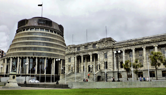
At last we reached Parliament House and the Executive Building, known for obvious reasons as the Beehive.  At the visitor entrance to Parliament, we underwent the standard security screening with a bag check and walk-through metal detector.  Security guards were friendly and welcoming.  Self-guided tours of the building were not permitted, and the guided tour came with heavy restrictions.  Because visitors are taken behind the scenes where ministers and members of Parliament are working, participants on the tour are not permitted to take any personal belongings.  This was similar to what we encountered at the U.S. Capitol.  
  space  
Where it differed was in where your belongings would be held.  Rather than in a secured locker with a key issued to us as in Washington, we were expected to surrender our passports and other valuables at the coat check, where they would be dumped into a plastic tub alongside those holding the possessions of other visitors.  Call us paranoid, but we were just not willing to comply with what we considered an unnecessary risk to our belongings, so we had to forgo the tour.
    
Beehive Building and Parliament House
After checking out the excellent exhibits in the Parliament House visitor center, we ventured over to Old St. Paul's Cathedral, another Wellington structure built from native timbers.  Constructed in the 1860s, the church served as the home of Wellington's Anglican congregation for almost 100 years.  Today it is a popular historic site and serves as a venue for a variety of cultural events.
Old St. Paul's Cathedral
When she learned we were American, the docent at Old St. Paul's pointed us toward a special exhibit of a U.S. flag and Marines flag.  During World War II, more than 20,000 U.S. Marines were stationed in the Wellington area.  With Japan so close by, the Marines' presence gave locals an improved sense of security, lacking since so many of their own men had been sent to foreign battlefields.

Heading back toward the hotel, we passed the National Library and couldn't resist popping in for a look.  We were treated to an outstanding exhibit on New Zealand innovators, free wifi, and a charming cafe, where we enjoyed a spot of tea.  Giving new meaning to "user-friendly," the library offered numerous cozy areas with comfortable seating where individuals and small groups could find a bit of privacy.

As we exited the library, rain began to fall—just the excuse we needed to flag a taxi for the return trip to the hotel, where we prepared a nice salad and began packing up to leave this charming city tomorrow.

Daily Stats:
  • Started in Picton, ended in Wellington
  • Mileage - 117   (Trip total: 15,103)
  • Weather - 42° to 58°, rainy, partly cloudy, WINDY
  • Miles walked -  wow, a bunch!
WEDNESDAY, 1 OCTOBER, & THURSDAY, 2 OCTOBER, 2014

Our ride from South to North
Wellington Harbor and City to Sea pedestrian bridge

A WANDER DOWN UNDER, Chapter 25: 
IN WHICH WE ARE REMINDED HOW NOT TO TRAVEL
      
Day 28:  Nelson to Picton

After a very interesting conversation with our innkeeper Max this morning, we departed from Nelson around 8:30, under cloudless blue skies, still thinking about a Florida couple we had just heard about from Max.  Apparently they were naively operating from an American interstate highway mindset when they did their New Zealand planning, for they decided it was feasible to drive from Queenstown to Nelson in a day.  
As the crow flies, the distance is about 350 miles.  But their rental car had no wings, so they had to travel by road, adding another 160 miles to their one-day journey.  Make no mistake, this drive bore no resemblance to the effortless 500-mile jaunt on the wide, straight, level ribbon of I-95 from Savannah to Miami.

This trip did have one facet in common with the Savannah-Miami route.  You could drive it on a single highway—the two-lane State Highway 6—but that's where the similarities ended.  Getting from Queenstown to Nelson requires traversing a half dozen mountain ranges, winding along hundreds of sharp curves and switchbacks, slithering along serpentine sections of coastal highway with sheer dropoffs and, as often as not, no guardrail as a safety net.  Throw in slow-downs for the many one-lane bridges and single-lane strips of road in the mountains, plus the novelty of left-lane driving, and it's obvious this trip will push past 12 hours.  And it did.

The hapless couple arrived at the hotel in Nelson near midnight, having driven through some of New Zealand's most beautiful scenery in the dark.  And before sunrise this morning, they sped off to Picton to catch a ferry to the North Island.  Having made similar kinds of miscalculations of our own, we felt really bad for them.  They flew halfway around the world to dash from place to place and miss much of what they came here to see.

After retracing our Monday route back to Havelock, the green-lipped mussel capital, we turned onto Queen Charlotte Drive, a 25-mile sinuous route edged with native forests.  The road continued winding lazily up and downhill past endless bays and coves and sounds, and even arms, until it meandered around one last bend into the town of Picton.

Just before we rolled into town we got a look at Waimahara Wharf in Shakespeare Bay, the exit port for some of the millions of logs exported from New Zealand each year.  One-third of New Zealand's timber exports go to China, their second largest trading partner.  
 space  
In Momonangi Bay, we spotted the Spirit of New Zealand, a 150-ft square rigger tall ship built for and used as the focus of a youth development program.  The core program accepts forty trainees, ages 15 to 18, from all over New Zealand.  Split evenly between male and female, the group is set afloat on a ten-day voyage to share the challenge of sailing a square rigger.  From their rigorous adventure, trainees reap confidence and friendships as well as a new set of skills.  And yes, more than a few bragging rights.

Spirit of New Zealand
Once in Picton, we checked into the Harbour View Motel, where our studio room featured a balcony overlooking the recently remodeled town marina.  Like many other tourists who visit Picton, we were there to catch the ferry from New Zealand's South Island to the North.  After a flavorful lunch at Le Cafe, a local bistro in the heart of town, we visited the ferry terminal to talk to the Hertz agent about the rental car process and to see the vessel we'll be riding to Wellington.

Picton port
We had heard that the international car rental companies do not permit their cars to cross from one of New Zealand's islands to the other.  As part of a single rental agreement, you drop off the car you've been driving on one island at the ferry terminal.  At your destination, the rental company has a similar car waiting at the terminal.  We were never able to determine the reasoning behind this rule, but it saved us the $100 ferry fare for the car, so we certainly did not object to the policy.

At the Picton port this afternoon, we spotted Sarah, a petite 30-something vagabond from Britain.  Wearing an 80-liter backpack on her back, a 25-liter one on her chest, and large tote bags on each shoulder, she was hard to miss. And her appearance stoked our curiosity about her travel story.  Surely she must be carrying a tent, sleeping bag and other camping gear with a load that large.  Wrong.

Sarah chuckled when we asked if she were camping, instead blaming her lengthy travel schedule for her excess baggage, which must have weighed 60 pounds or more.  She explained that she is in the final third of a nine-month trip, with three months in Southeast Asia, three in Australia, and three in New Zealand.  We were quite eager to hear about her adventures and why she would carry so much "stuff" around with her, but she had a ferry to catch, and since she laughed in response to Ken's inquiry about her penning a book about her travels, we'll never know.

Picton Town Marina
While I worked on the blog this afternoon, Ken crossed the Coathanger Bridge to Shelley Beach on the opposite side of the marina for a hike on the scenic Harbour View Trail.  Since we must report to the ferry terminal by 7 a.m. tomorrow, we turned in early to rest up for our North Island adventures.

Daily Stats:
  • Started in Nelson, ended in Picton
  • Mileage - 78  (Trip total: 14,986)
  • Weather - 39° to 57°, sunny
  • Overloaded British tourists - 1
  • Frenzied American tourists - 2
  • Gas price - $6.96/gallon
TUESDAY, 30 SEPTEMBER, 2014

A WANDER DOWN UNDER, Chapter 24: 
IN WHICH WE SEEK TREASURE
      
Day 26:  Kaikoura to Nelson

A cold morning greeted us in Kaikoura as we saw the temperature dip down to 35°.  A fresh coating of snow graced the peaks of the nearby Sewards and collaborated with a brilliant sun to create a stunning backdrop for our continuing drive north on SH-1  (pictured above).   It seemed a bit odd to watch the morning sun rising above the Pacific Ocean, which is on the west coast back home.

About 14 miles north of Kaikoura, we pulled over at the Ohau Point Lookout to spy on the breeding colony of New Zealand fur seals that live there.  Judging by the air temp, the water sloshing into the rocky shoreline at high tide this morning must have been icy.  But these guys have a double fur coat and were not bothered, especially the young ones.  Dozens of the little guys were having a grand old time diving and frolicking in a semi-sheltered rock pool.  When an occasional high wave surged into their play area, it only seemed to jack up the excitement, like kids on a roller coaster.  In the fashion of their human counterparts, the adults lounged in the sun on nearby rocks, occasionally taking time from their napping to observe the antics of their children.

Seal pool at Ohau Point
As the road wound inland and then back to the coast, we entered yet another splendid area of plump verdant hills peppered with thousands of sheep.  A major center of sheep farming, New Zealand has the world's highest sheep population density.  According to a recent report, New Zealand is home to more than 30 million sheep, almost seven times its human population.  Ewe couldn't prove it by us and we're not trying to fleece you or pull the wool over your eyes, but we herd that a farmer near Christchurch rammed his way into the Guniness book with a world record flock numbering 384,143 sheep.  (Please don't lambaste us and forgive the baaaad puns.)

Have you any wool?
Nearing the town of Blenheim, our attention was diverted by signs to the Lake Grassmere Saltworks.  Snowy mountains of salt lured us down a side road to the plant where more than 60,000 tons of salt are harvested annually.  Sea water is pumped into the 1,700-acre lake during the summer when the Marlborough region's long hours of sun and strong winds begin the evaporation process that increases the water's salinity.  As nature does its work, the water is transferred to a series of concentrating ponds for further evaporation.  When the brine reaches saturation point, it goes into crystallization ponds for the final stage of dehydration.

Lake Grassmere Saltworks
At the crossroads in Blenheim, we turned west on SH-6 toward Nelson, our destination for the day.  We had entered yet another New Zealand wine-producing area, this one called the Wairau Valley region, New Zealand's premier and best known, with 130 wineries.  As in the area north of Christchurch yesterday, vineyards lined both side of the highway.  These were industrial-size wineries with multiple massive storage tanks and significant processing plants.

The further we drove into the Marlborough region, the higher the roadside views became as we drove through the Richmond Range.  After miles of pastured hillsides, we stopped for lunch in Havelock, the self-proclaimed 'Green-Lipped Mussel Capital of the World.'  We struggled to decide whether we should eat at the Havelock Cafe, the Havelock Lodge, the Havelock Inn, or one of the other creatively named restaurants, finally settling on one that offered some vegetarian options in addition to all those emerald shell mollusks.

Green-Lipped Mussels
Arriving in Nelson in the early afternoon, we decided to go seek a couple of letterboxes west of the town after checking in at The Sails hotel.  Our search for the first box took us to a park at the end of the narrow, twisting Riwaka Valley Road, where we set out on the Riweka Resurgence Trail.  The path was sheltered by a very dense, very moist rain forest.  Moisture was so thick your exhaled breath could be seen as vapor.  Near a picnic area off the trail, we followed a narrow track into the forest seeking a head-high stump leaning toward the river.  Though we located the stump, no treasure was hiding within or nearby.  Its close proximity to the river may well have been behind its disappearance.Though the letterbox was AWOL, we continued out the trail to a platform overlooking the cave where the Riwaka River bubbles up from its underground journey.
     
Riwaka Resurgence Trail
Our second letterbox target had not been reported as found in more than five years, so we held out little hope of locating it, but it had been planted in the popular beach town of Kaiteriteri (kie-teery-teery), just a few miles away.  With a name that charming, it was a must-see.  Alas, the box was also MIA, but the beach was quite attractive with a caravan village that looked to be at maximum capacity.

Kaiteriteri beach
Though our innkeeper's rapid fire list of recommendations when we checked in included a couple of restaurants that were not seafood-centered, we opted to continue our self-catering habit and picked up dinner supplies at the local New World supermarket on our way back to the hotel.

Tomorrow we have a short drive to the quaint coastal town of Picton, where we'll end our stay on New Zealand's South Island.
Daily Stats:
  • Started in Kaikoura, ended in Nelson
  • Mileage -  254    (Trip total: 14,908)
  • Weather - 35° to 62°, sunny
  • Grains of salt - 452,752,967,021,489,111
  • Missing letterboxes - 2
  • Green-lipped mussels - 18,402
MONDAY, 29 SEPTEMBER, 2014

The morning sun over the Pacific
Ohau Point
Really?  Outside the Omaka Aviation Heritage Centre in Blenheim
A collection of new Toyotas parked in a pasture near the Omaka Aviation Heritage Centre


A WANDER DOWN UNDER, Chapter 23: 
IN WHICH TIME SHIFTS, AND WE DO TOO
      
Day 26:  Christchurch to Kaikoura
  space  
As we were sleeping last night, New Zealand implemented Daylight Saving Time and "sprang forward" one hour.  Thus when I awoke this morning and saw 6 a.m. on my watch, I was mistaken in thinking I had two hours to drag around before our agreed upon departure time from Christchurch.  A few minutes later, Ken awoke and looked at his phone.  "Already after 7?" he remarked.  My "extra" hour evaporated and, though we both had plenty of sleep, we were just a little out of step.

By the time we packed up and moved out of our stylish apartment, checked out, and bid farewell to the charming innkeeper Carol, it was 8:45.  We asked the GPS to take us to the coastal town of Kaikoura, and off we went,  Less than a block later, we discovered just how disoriented we were.  When directed to turn right onto Peterborough Street by the GPS, we did, driving in the right lane.  Immediately, both of us sensed that something was amiss, but neither figured out our error until we reached the end of this short block and realized that we had just executed the error of wrong-way driving, something we've struggled to avoid for the past month.  Fortunately for us—and potential victims—there was very little traffic that early on time-change Sunday morning.
  space  
Nevertheless, a jolt of caffeine seemed like a good idea, so we pulled into the drive-thru at a nearby Macca's (New Zealand's nickname for McDonald's) for a large Diet Coke and a free "senior" coffee.  Thus fortified, we drove north on State Highway 1.  Leaving the Christchurch area, the road split into a divided, limited-access freeway, the first we have experienced in New Zealand, but fewer than ten miles later, we were back on the familiar bumpy two-laner with occasional one-lane bridges.

Soon we found ourselves surrounded by manicured rows of grapevines (pictured above), lining both sides of the highway.  We had entered the Waipara Valley wine region, renown as a premium area for its pinot noir, riesling, and chardonnay wines.  With the highest summer temperatures of the New Zealand wine regions, Waipara produces more than 100,000 cases of wine each year.

Past Waipara, we drove through the lush fields and pastures of the Greta River valley and stopped for a break at the cozy Mainline Station Cafe in the modest hamlet of Domett.  Over a cup of tea and a freshly baked parmesan and spinach scone, we chatted with cafe owner John, a veteran of the cruise ship industry.

Having trained under a talented chef in his native Christchurch, John indulged his yen for adventure, securing work in Amsterdam and later Perth, before hiring on with Crystal Cruise lines.  After he had sailed the south seas for a couple of years, fate intervened when the young woman who would become his wife joined the ship's crew.  When the two of them later decided it was time to return to dry land and raise a family, they opted for the relaxed pace of a small town cafe.  During the winter months, they shutter their doors, pack up their two little ones, and feed their adventurous spirits again.

Later in the day, as we approached Kaikoura on the east coast, we entered the Seward Kaikoura Coastal range, winding our way on SH-1, as it skirted the rocky shores wedged between the mountains and the Pacific Ocean.  A cold rain began falling a few miles south of Kaikoura and continued as we checked in at the Aspen Court motel.

After perusing the handy collection of local restaurant menus at the motel, we decided on the Black Rabbit Pizza Company and sloshed back to the cafe on Highway 1, only to find the door locked and adorned with a post-it note indicating "Back in 5."  The awning gave us the time we needed to notice two other signs posted on the Black Rabbit's front window:  'TripAdvisor Certificate of Excellence' (for consistently high reviews) and 'Free Wifi.'  
  space  
Before we had time to even consider getting back into the rain to walk away from those tempting offers, a small white hatchback zipped up to the curb nearby, and out jumped a breathless young lady, jamming a key in the door as she thanked us for waiting.  This was Laurel, who owns the shop with her husband Josh, and her pizza, made with fresh, locally sourced ingredients with an aim toward full flavor, was well worth the minor delay.

 By the time we polished off the entire large pizza and caught up on email, news and football scores, the rain had taken a breather, so we drove out Fyffe Quay toward the southeastern tip of the Kaikoura Peninsula to visit some popular town residents. Along the way we paused to check out an isolated chimney along the shore.  This lonely sentinel was once part of the local customs house in the days when Kaikoura was port-dependent with no rail or road connections.

Kaikoura Rocks
Near the chimney was evidence of an earlier history.  Much earlier.  According to geologists, about 180,000 years ago, a rapid seismic uplift raised and twisted layers of limestone and siltstone from the ocean bed to the surface.  Today these vertical versions of the "pancake rocks" we saw on the west coast decorate the shore line of what is now Kaikoura.

As interesting as these intermediate stops were, what we really wanted to see was at the end of the road. In recent years, Kaikoura has become the epicenter of New Zealand's marine life tours, but today's weather had kept the whale and dolphin watching boats in the harbor.  Our only opportunity for a close encounter with a marine mammal was offered by the Fyffe Quay seal colony.  Undaunted by the fog and rain, these New Zealand fur seals were out there performing for their paparazzi.  They yawned and lolled and even posed for the tourists who made the pilgrimage to their rocky shore home.

Long a target for fur harvesters, these seals were brought back from the brink of extinction by protective legislation.  The population has rebounded, and Fyffe Quay hosts one of several thriving colonies in the Kaikoura area.

By the time we pulled ourselves away from these winsome hosts and drove up to the town overlook at the end of Maui Street, the rain was back to stay.  We yielded to a stronger foe and called it a day, returning to the hotel for the night.

Tomorrow we'll continue up the South Island's east coast before turning back west to Nelson on the northern shore.

Daily Stats:
  • Started in Christchurch, ended in Kaikoura
  • Mileage -   130  (Trip total: 14,654)
  • Weather - 41° to 46°, overcast, windy, rainy
  • Grapevines - 34,910
  • New Zealand fur seals - 62
  • Sheep - 7,241
SUNDAY, 28 SEPTEMBER, 2014

Journaling and a lovely cup of tea at the Mainline Station Cafe
Statement hedge in front of a Kaikoura home
Nice view of the town from the Maui Street overlook.

A WANDER DOWN UNDER, Chapter 22: 
IN WHICH THINGS GET A BIT SHAKY
      
Days 24 & 25:  Christchurch
  space  
In early 2010, Christchurch was known as the Garden City, an urban area that dedicated more than most cities to green space.  Grand old buildings sat amid stately beech and chestnut trees along the city's picturesque streets, and its population had recently surpassed that of Wellington to make it New Zealand's second largest city.   (Worcester Street, Christchurch, in July, 2010 pictured above)

Then on September 4, 2010, a 7.1 magnitude earthquake struck, its epicenter just 25 miles from Christchurch.  Aftershocks continued for many months, with the most devastating centered very close to the city—a shallow 6.3 quake on February 22, 2011.  Destruction was widespread, and 185 people were killed, more than 11,000 injured.  Survivors continued to be battered, both physically and emotionally, by an unrelenting swarm of aftershocks.  By August, 2012, more than 11,000 aftershocks with a magnitude of 2.0 or greater had been recorded, including 26 over magnitude 5.

Christchurch Cathedral, September, 2014
When the 2011 quake slammed the city, the steeple of the bluestone Chrischurch Cathedral, the physical and symbolic heart of the city toppled, ripping a gaping hole in the narthex.  Many other buildings, some weakened in the previous September's quake and its aftershocks, collapsed into rubble.  As many as 1,000 structures in the central business district were destroyed or undermined.  Before locals could begin to clear the debris, another large aftershock on June 13 wreaked considerably more damage.

Due to instability in the area of greatest destruction, a "red zone" was established after the February 2011 quake, excluding all but emergency personnel from the central city.  As rubble was cleared, the zone shrank in size until the final barriers were removed in June, 2013.  Today large areas of the devastated garden city remain unrenewed.  Hulking shells of critically damaged buildings still await demolition.  Miles and miles of temporary fencing stand between the curious and these unstable structures.  In some instances, shipping crates have been employed in an effort to keep historic facades from crumbling.

Saving this old facade, but for what purpose?
Rebuilding cost estimates surged with each new event.  Like major hurricane disasters in the U.S., devastation at this level far exceeds the power of a local, or even state, government to manage.  By the time of the June, 2011 quake, the amount of damage was equivalent to 20% of New Zealand's annual GDP (compared with Katrina damage equivalent to a paltry 1% of American GDP).  Economists estimate it may take the New Zealand economy 50 to 100 years to recover.  Yet with almost 100 faults and fault segments identified in the Christchurch area, some within 12 miles of the central city, seismologists have predicted that Christchurch has the potential for a major earthquake about every 55 years.

One of many vacant lots in the central city
Upwards of 11,000 residents (about 4%) understandably abandoned the city in the aftermath of this overload of seismic activity.  Yet the population is rebounding, though the recovery process has been overwhelmed by a surfeit of ideas and political jockeying.  The idea of central Christchurch as a "blank canvas" took hold, and no one wanted to bungle the opportunity to create the ideal city.  So precincts were conceived for every purpose—an arts precinct, healthcare precinct, retail precinct, government precinct, and on and on.  None of that typical organic, natural process of city growth would be tolerated.  This was the chance to "fix" everything.

But people needed to get on with their lives.  While those in power in the central city dawdled, construction began in the areas just outside the CBD that weren't affected by the quakes.  Today law firms and other major tenants for downtown office space have signed multiyear leases in these structures, eliminating the opportunity to fill new buildings which still have yet to be built in the central city.

The church's plan to demolish the ruins of the cathedral and rebuild were waylaid when preservationists invoked court interference based on the historic value of the original structure.  In the interim, the congregation employed a Japanese architect who specializes in designing temporary post-earthquake structures.  Created from massive cardboard tubes, timber and steel, the Christchurch Cardboard Cathedral opened its doors in August, 2013 several blocks away from the ruins.  Designed to serve for fifty years, the new structure seats 700 and has become a popular event space as well as a center for worship.

Cardboard Cathedral
Other temporary structures which seemed funky and clever in the months after the disaster continue to dominate the city center.  Re:START Mall, a conglomeration of retail shops, banks and other businesses housed in shipping containers, opened on the city's main pedestrian mall in October, 2011.  They remain at the heart of the retail recovery.

Re:START Mall
Organizations like Gap Filler popped up in the days after the 2011 disaster.  With their stated goal of facilitating the use of vacant sites and buildings in Christchurch, they must have been a breath of fresh air, organizing events and putting up temporary structures with recycled materials like wooden shipping pallets.  Four years later, their efforts to "activate vacant lots with cool and creative projects" while the city still sits in ruins don't seem as relevant, though today their primary funding source is the Christchurch City Council. How long should these transitional efforts remain the focus?

A Christchurch local told us of watching a television documentary recently about the 1995 earthquake that decimated Kobe, Japan, leaving more than 150,000 buildings destroyed and more than 4,000 residents dead.  "After four years, you couldn't even tell there had been an earthquake there," the local marveled.  "And look at us after four years."

It is immediately apparent that Japan, with the world's third largest economy, had infinitely more resources to support the Kobe recovery effort.  But money aside, protracted conflict and mistrust among levels of government seems to have sapped the wind from the Christchurch recovery sails.  Potential foreign investors are losing patience and looking elsewhere.

In twenty years, Christchurch will probably be restored, or reinvented, into a vibrant city again.  But that's another generation away.  How many of those who grow up amid the rubble will remain?

FRIDAY, 26 SEPTEMBER & SATURDAY, 27 SEPTEMBER, 2014

Asbestos removal crews are doing a booming business in the city 
After prolonged insurance settlements, some residences are just now being restored.
A window on Christchurch
Since the Red Zone was eliminated, rolling street closures permit demolition work to continue.
Planted Whare, a city council sponsored project to provide "a hopeful presence" in Cathedral Square
185 Chairs:  Even this memorial to the victims of the 2011 earthquake has an air of impermanence.