


IN WHICH FIND AN EXCLAVE
space.
Day 18. Sikeston, MO to St. Louis, MOspace.
Just before 9:00, we pulled out of Sikeston, MO, under heavy gray clouds, a grim reminder of the strong storms forecast for this area over the next couple of days. As we drove north, patches of blue sky became visible. We are finding life off the freeways a pleasant change—less traffic, slower pace, and rumble strips announce when an occasional driver is about to pass.
After a correction when the GPS got carried away with our “avoid freeways” directive and took us far west off the path to St. Louis, we returned east on MO-74 into Cape Girardeau, a charming river town we had visited in 2011. There we found a couple of letterboxes before meandering out of town on Highway W, which led us back to US-61.
space
 |
| Farm near Jackson, MO |
We continued north on the Great River Road as it wound through hilly farm lands carpeted with emerald grass. On a whim, we turned east from Uniontown onto Highway A, following signs to “historic downtown Altenburg.” We decided to follow the road to the Mississippi River, which led us to the Tower Rock Natural Conservation Area at the end of CR-461.
space.
Sitting in the middle of the river, Tower Rock is a tall limestone island which was formed over many hundreds of years by the Mississippi’s periodic channel shifts. French explorer Marquette provided the first written description of the rock in 1673, and William Clark documented it as his expedition with Meriwether Lewis passed the spot in 1803.
space.
space.
 |
| Tower Rock |
A little park on the riverbank near the rock offered the perfect spot to eat our picnic lunch as we watched logs floating downstream and barges going upstream. On the way back to Highway A, we stopped to check out the impressive Grand Tower Pipeline Bridge. Originally built in 1955, this suspension bridge carries natural gas over the river, part of an interstate pipeline transporting natural gas from Texas to the Midwest.
 By the time of the American Revolution, the town had fallen into British hands, serving as an administrative center and making it a target of American forces. George Rogers Clark led a milita expedition from Virginia to capture Kaskaskia—more than 1,000 miles over two months. Before they arrived in July, 1778, the British had withdrawn. On July 4, Clark celebrated American occupation of the town by ringing the bell given by King Louis XV to the Catholic Church of the Illinois Country in 1741.
Upon its capture, Kaskaskia was named the seat of Virginia’s Illinois County, and in 1787 became part of the Northwest Territory. When Illinois was designated a separate territory in 1809, Kaskaskia was named its capital, a status it retained into the first year of Illinois statehood, replaced in 1819 by the centrally located Vandalia. A worse fate was yet to come.
In April, 1881, spring flooding of the Mississippi River wiped out most of Kaskaskia. At the same time, the Mississippi shifted eastward, moving into the channel of the Kaskaskia River and leaving the remains of the town on the Missouri side of the mighty river—an exclave of Illinois. Today a handful of buildings and a few residents are the only reminders of this once thriving town.
We hadn’t been on I-55 five miles before rain descended in swollen drops—so large they made plopping noises as they hit the car. Weather radar offered no reassurance. Our path was about to intersect with a powerful storm cell. In confirmation, the sky darkened and lightning began to flash wildly.
Soon the rain became a torrent, so heavy the wipers struggled to keep up with the volume of water. As we monitored the NOAA weather radar, we watched as the yellow cell we were driving through was displaced by orange, which itself was being shoved eastward by a significant knot of red.
Pushing on northward, we were able to slip between that cluster of intense precipitation and another ahead which was still a bit west of our route. By the time we entered St. Louis proper, the rain had slid away southeast.
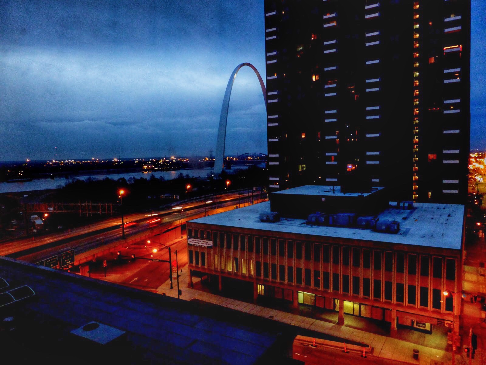
Arriving just after 4:30, we checked into the Hampton Inn near the famed Gateway Arch and unpacked the car. Unable to resist the convenience after our stressful drive, we ate dinner in the Tigin Irish Pub at the hotel. It turned out to be quite good.
As another storm system swept through the city later that evening, we watched the lightning display from our ninth floor windows, glad to be still and dry.
space
 |
| Grand Tower Pipeline Bridge |
Before returning to US-61, we stopped in Altenburg (pop. 352), one of a cluster of five villages established in the 1830s by Lutheran immigrants from the Saxony region of Germany. Soon after the town’s founding, residents established a log cabin college, which introduced the then radical idea of co-educational schooling. The local Lutheran Heritage Center maintains a museum and a few historic buildings, including the school.
 |
| Log Cabin College in Altenburg |
Near 2:30, we entered St. Mary, MO, where we crossed over a stream into an exclave of Illinois—Kaskaskia (pop. 14), the second smallest incorporated community in the state. First settled in 1703 on the site of an old Native American village, Kaskaskia became a major French colonial center, reaching its peak population of 7,000 by the mid-18th century.

Upon its capture, Kaskaskia was named the seat of Virginia’s Illinois County, and in 1787 became part of the Northwest Territory. When Illinois was designated a separate territory in 1809, Kaskaskia was named its capital, a status it retained into the first year of Illinois statehood, replaced in 1819 by the centrally located Vandalia. A worse fate was yet to come.
In April, 1881, spring flooding of the Mississippi River wiped out most of Kaskaskia. At the same time, the Mississippi shifted eastward, moving into the channel of the Kaskaskia River and leaving the remains of the town on the Missouri side of the mighty river—an exclave of Illinois. Today a handful of buildings and a few residents are the only reminders of this once thriving town.
 |
| Kaskaskia Bell Memorial |
After visiting this spot rife with ghosts and history, we left under heavy clouds and drove through Ste. Genevieve on US-61. As the weather continued to threaten, we were convinced to break our interstate avoidance vow and move over to I-55 to finish the trip into St. Louis. Severe thunderstorms were passing through the area with a watch in effect until 6 p.m.
We hadn’t been on I-55 five miles before rain descended in swollen drops—so large they made plopping noises as they hit the car. Weather radar offered no reassurance. Our path was about to intersect with a powerful storm cell. In confirmation, the sky darkened and lightning began to flash wildly.
Pushing on northward, we were able to slip between that cluster of intense precipitation and another ahead which was still a bit west of our route. By the time we entered St. Louis proper, the rain had slid away southeast.
Arriving just after 4:30, we checked into the Hampton Inn near the famed Gateway Arch and unpacked the car. Unable to resist the convenience after our stressful drive, we ate dinner in the Tigin Irish Pub at the hotel. It turned out to be quite good.
As another storm system swept through the city later that evening, we watched the lightning display from our ninth floor windows, glad to be still and dry.
space.
WEDNESDAY, 8 APRIL 2015
space.
Daily Stats- Miles driven: 208
- Weather: 'nuff said
- Silos: 451
- Barns: 239
- Lumber stacks in Altenburg: 41,893
- Wildflowers: 459,760
 |
| Cloche Français, Kaskaskia |
 |
| Here comes the rain |
 |
| Entering St. Louis between storms |
 |
| Sun-dried tomato hummus with boxty wedges at Tigin Irish Pub |
 |
| Glad to be tucked in for the night |


